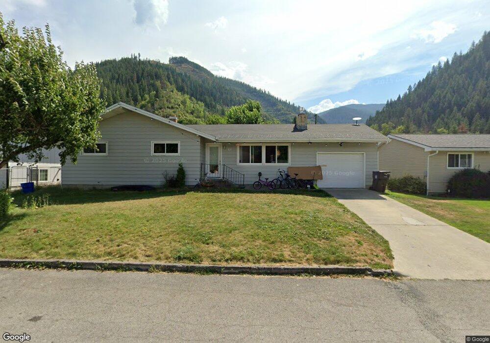
121 W Larch Ave Osburn, ID 83849
Estimated Value: $332,000 - $405,000
5
Beds
3
Baths
2,400
Sq Ft
$156/Sq Ft
Est. Value
About This Home
This home is located at 121 W Larch Ave, Osburn, ID 83849 and is currently estimated at $374,236, approximately $155 per square foot. 121 W Larch Ave is a home located in Shoshone County with nearby schools including Silver Hills Elementary School and Wallace Junior/Senior High School.
Ownership History
Date
Name
Owned For
Owner Type
Purchase Details
Closed on
May 24, 2013
Sold by
Mcgraw Monica L and Brandis Justin M
Bought by
Henderson Benjamin T and Henderson Maudi M
Current Estimated Value
Home Financials for this Owner
Home Financials are based on the most recent Mortgage that was taken out on this home.
Original Mortgage
$109,250
Interest Rate
3.79%
Purchase Details
Closed on
Dec 1, 2011
Sold by
Carleton Nancy L and Carleton William
Bought by
Mcgraw Monica L and Brandis Justin M
Home Financials for this Owner
Home Financials are based on the most recent Mortgage that was taken out on this home.
Original Mortgage
$107,211
Interest Rate
3.75%
Mortgage Type
FHA
Purchase Details
Closed on
Aug 25, 2009
Sold by
Ward Brian C
Bought by
Ward Catherine M
Create a Home Valuation Report for This Property
The Home Valuation Report is an in-depth analysis detailing your home's value as well as a comparison with similar homes in the area
Home Values in the Area
Average Home Value in this Area
Purchase History
| Date | Buyer | Sale Price | Title Company |
|---|---|---|---|
| Henderson Benjamin T | -- | First American Title | |
| Mcgraw Monica L | -- | First American Title Co | |
| Ward Catherine M | -- | -- |
Source: Public Records
Mortgage History
| Date | Status | Borrower | Loan Amount |
|---|---|---|---|
| Previous Owner | Henderson Benjamin T | $109,250 | |
| Previous Owner | Mcgraw Monica L | $107,211 |
Source: Public Records
Tax History Compared to Growth
Tax History
| Year | Tax Paid | Tax Assessment Tax Assessment Total Assessment is a certain percentage of the fair market value that is determined by local assessors to be the total taxable value of land and additions on the property. | Land | Improvement |
|---|---|---|---|---|
| 2025 | $1,712 | $336,909 | $44,355 | $292,554 |
| 2024 | $1,712 | $336,909 | $44,355 | $292,554 |
| 2023 | $1,712 | $340,563 | $44,355 | $296,208 |
| 2022 | $2,134 | $310,291 | $40,279 | $270,012 |
| 2021 | $2,053 | $241,032 | $34,408 | $206,624 |
| 2020 | $1,758 | $180,601 | $30,723 | $149,878 |
| 2019 | $1,794 | $177,853 | $28,327 | $149,526 |
| 2018 | $1,454 | $120,459 | $25,752 | $94,707 |
| 2017 | $1,415 | $120,459 | $25,752 | $94,707 |
| 2016 | $1,389 | $112,932 | $25,752 | $87,180 |
| 2015 | -- | $112,932 | $25,752 | $87,180 |
| 2014 | -- | $112,932 | $25,752 | $87,180 |
Source: Public Records
Map
Nearby Homes
- 315 W Yellowstone Ave
- 511 E Idaho Ave
- 905 Terror Gulch Rd
- 0 Cameron Dr Unit 25-1685
- 712 W Yellowstone Ave
- 807 E Garden Ave
- 235 Rio Vista St
- 225 Rio Vista St
- 1154 E Larch Ave
- Lot 2B Upper Dr
- 67 Nuchols Gulch Rd
- 104 Ninth St
- 3 Polaris Peak Rd
- 1 Polaris Peak Rd
- 2 Polaris Peak Rd
- 99 Sather Field Rd
- 498 Revenue Gulch Rd
- NNA County Club Rd
- 86 E Circle Dr
- 930 Moon Gulch Rd