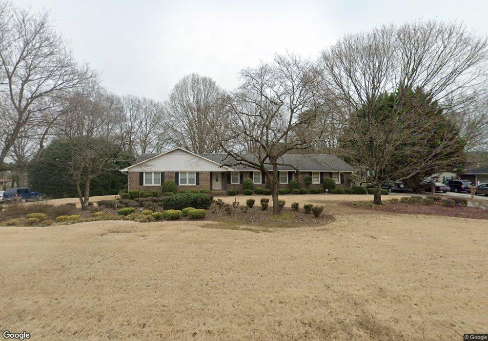
121 Windsor Dr Calhoun, GA 30701
Estimated Value: $281,590 - $368,000
3
Beds
2
Baths
2,109
Sq Ft
$159/Sq Ft
Est. Value
About This Home
This home is located at 121 Windsor Dr, Calhoun, GA 30701 and is currently estimated at $334,398, approximately $158 per square foot. 121 Windsor Dr is a home located in Gordon County with nearby schools including Calhoun Primary School, Calhoun Elementary School, and Calhoun Middle School.
Ownership History
Date
Name
Owned For
Owner Type
Purchase Details
Closed on
Nov 10, 2008
Sold by
Not Provided
Bought by
Mosteller M Robert
Current Estimated Value
Home Financials for this Owner
Home Financials are based on the most recent Mortgage that was taken out on this home.
Original Mortgage
$120,000
Outstanding Balance
$78,028
Interest Rate
5.89%
Mortgage Type
New Conventional
Estimated Equity
$256,370
Purchase Details
Closed on
Nov 16, 2005
Sold by
Jordon Richard
Bought by
Kitchens Paul
Home Financials for this Owner
Home Financials are based on the most recent Mortgage that was taken out on this home.
Original Mortgage
$156,000
Interest Rate
6.88%
Mortgage Type
New Conventional
Purchase Details
Closed on
Mar 31, 2000
Bought by
Jordon Richard and Jordon Nancy
Purchase Details
Closed on
Jun 2, 1996
Bought by
Maddox Tommy L
Create a Home Valuation Report for This Property
The Home Valuation Report is an in-depth analysis detailing your home's value as well as a comparison with similar homes in the area
Purchase History
| Date | Buyer | Sale Price | Title Company |
|---|---|---|---|
| Mosteller M Robert | $150,000 | -- | |
| Kitchens Paul | $195,000 | -- | |
| Jordon Richard | $148,000 | -- | |
| Maddox Tommy L | $126,500 | -- |
Source: Public Records
Mortgage History
| Date | Status | Borrower | Loan Amount |
|---|---|---|---|
| Open | Mosteller M Robert | $120,000 | |
| Previous Owner | Kitchens Paul | $156,000 |
Source: Public Records
Tax History Compared to Growth
Tax History
| Year | Tax Paid | Tax Assessment Tax Assessment Total Assessment is a certain percentage of the fair market value that is determined by local assessors to be the total taxable value of land and additions on the property. | Land | Improvement |
|---|---|---|---|---|
| 2023 | $883 | $73,620 | $5,600 | $68,020 |
| 2022 | $638 | $69,100 | $5,600 | $63,500 |
| 2021 | $682 | $57,380 | $5,600 | $51,780 |
| 2020 | $696 | $58,140 | $5,600 | $52,540 |
| 2019 | $692 | $58,140 | $5,600 | $52,540 |
| 2018 | $504 | $54,320 | $5,600 | $48,720 |
| 2017 | $487 | $51,520 | $5,600 | $45,920 |
| 2016 | $488 | $51,520 | $5,600 | $45,920 |
| 2015 | $482 | $50,560 | $5,600 | $44,960 |
| 2014 | $460 | $49,226 | $5,600 | $43,626 |
Source: Public Records
Map
Nearby Homes
- 127 Windsor Dr
- 130 Cambridge Ct
- 140 Cambridge Ct
- 129 Derby Ln
- 114 Lindsey Ct NE
- 326 Curtis Pkwy NE
- 201 Crestmont Dr
- 202 Montclair Dr
- 121 Hunt Dr
- 103 Mims Dr
- 1125 Dews Pond Rd SE
- 218 Newtown Rd NE
- 133 Kentucky Dr NE
- 2148 Red Bud Rd NE
- 105 Garden Hill Dr
- 209 Willowbrook Dr SE
- 113 Oakhurst Terrace NE
- 511 Boulevard Heights
- 154 Millers Ln
- 105 Twin Oaks Dr