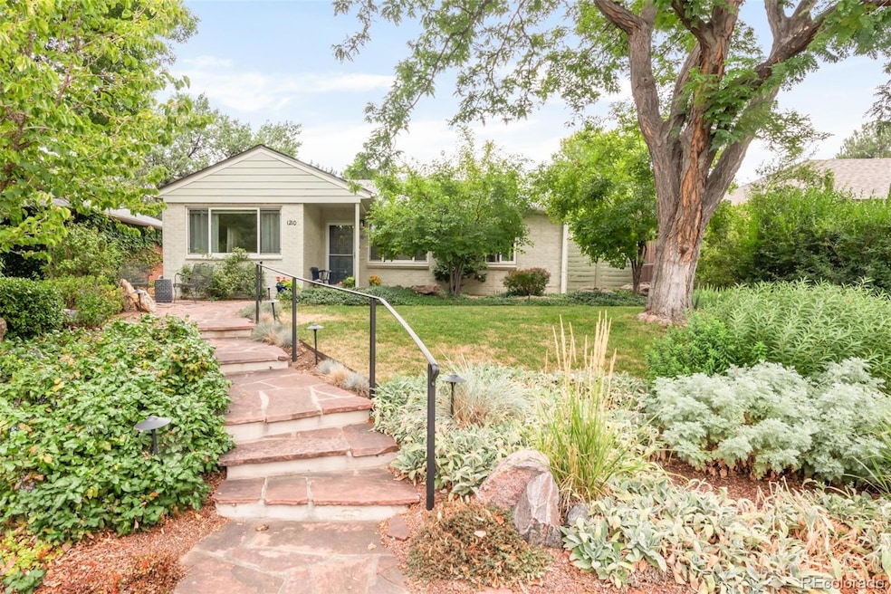
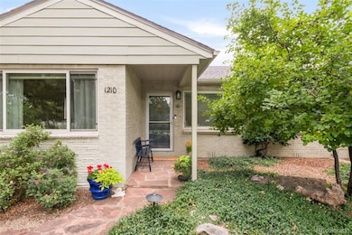
1210 Locust St Denver, CO 80220
Montclair NeighborhoodEstimated payment $3,153/month
Highlights
- Open Floorplan
- Deck
- Wood Flooring
- George Washington High School Rated A-
- Traditional Architecture
- Private Yard
About This Home
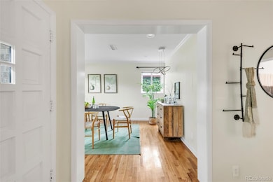
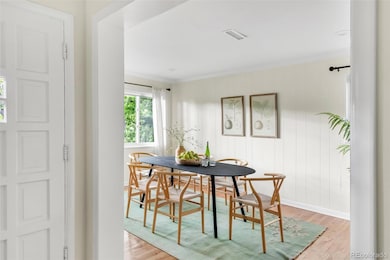
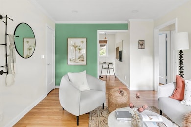
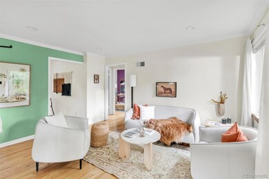
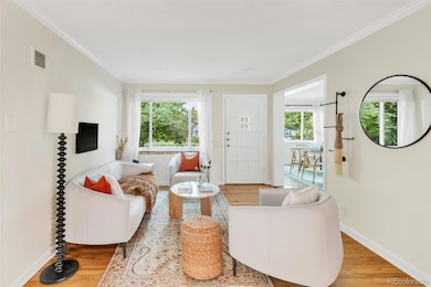
Tucked within historic Montclair, this delightful home offers a rare balance of charm, comfort and serene outdoor living. A welcoming exterior with a front patio leads into a light-filled living room framed by a wide picture window and classic moldings. The dining room offers a bright and inviting space for gatherings, while the kitchen provides generous cabinetry, a stackable washer and dryer set and effortless functionality. Two versatile bedrooms and a full bath with a walk-in shower complete the interior. Outside, the property truly shines — an enchanting backyard retreat showcases a covered deck and a beautifully designed garden with lush greenery and a dry riverbed, creating a peaceful sanctuary for year-round enjoyment. A detached one-car garage and a newer evaporative cooler enhance comfort and convenience. With easy access to local restaurants and markets, this well-maintained home is a rare opportunity to experience both inviting comfort and exceptional outdoor tranquility.
Listing Agent
Milehimodern Brokerage Email: emily@hello303.com,303-564-3534 License #40037488 Listed on: 08/27/2025
Home Details
Home Type
- Single Family
Est. Annual Taxes
- $2,412
Year Built
- Built in 1949
Lot Details
- 5,850 Sq Ft Lot
- West Facing Home
- Landscaped
- Level Lot
- Private Yard
- Garden
- Grass Covered Lot
- Property is zoned E-SU-DX
Parking
- 1 Car Garage
Home Design
- Traditional Architecture
- Brick Exterior Construction
- Composition Roof
- Wood Siding
Interior Spaces
- 970 Sq Ft Home
- 1-Story Property
- Open Floorplan
- Built-In Features
- Window Treatments
- Living Room
- Dining Room
- Wood Flooring
Kitchen
- Walk-In Pantry
- Oven
- Range
- Dishwasher
Bedrooms and Bathrooms
- 2 Main Level Bedrooms
- 1 Bathroom
Laundry
- Laundry in unit
- Washer
Outdoor Features
- Deck
- Covered Patio or Porch
- Exterior Lighting
- Rain Gutters
Schools
- Palmer Elementary School
- Hill Middle School
- George Washington High School
Utilities
- Evaporated cooling system
- Forced Air Heating System
- Natural Gas Connected
- Water Heater
- High Speed Internet
- Phone Available
- Cable TV Available
Community Details
- No Home Owners Association
- Montclair Subdivision
Listing and Financial Details
- Exclusions: Seller's personal property and/or staging items and yard ornaments.
- Assessor Parcel Number 6052-19-018
Map
Home Values in the Area
Average Home Value in this Area
Tax History
| Year | Tax Paid | Tax Assessment Tax Assessment Total Assessment is a certain percentage of the fair market value that is determined by local assessors to be the total taxable value of land and additions on the property. | Land | Improvement |
|---|---|---|---|---|
| 2024 | $2,412 | $37,150 | $25,550 | $11,600 |
| 2023 | $2,359 | $37,150 | $25,550 | $11,600 |
| 2022 | $1,870 | $30,470 | $24,260 | $6,210 |
| 2021 | $1,805 | $31,340 | $24,960 | $6,380 |
| 2020 | $1,682 | $29,820 | $24,960 | $4,860 |
| 2019 | $1,635 | $29,820 | $24,960 | $4,860 |
| 2018 | $1,397 | $25,260 | $16,750 | $8,510 |
| 2017 | $1,393 | $25,260 | $16,750 | $8,510 |
| 2016 | $1,062 | $20,980 | $17,369 | $3,611 |
| 2015 | $1,017 | $20,980 | $17,369 | $3,611 |
| 2014 | $725 | $16,690 | $13,898 | $2,792 |
Property History
| Date | Event | Price | List to Sale | Price per Sq Ft |
|---|---|---|---|---|
| 11/11/2025 11/11/25 | Price Changed | $560,000 | -4.6% | $577 / Sq Ft |
| 10/10/2025 10/10/25 | Price Changed | $587,000 | -2.2% | $605 / Sq Ft |
| 08/27/2025 08/27/25 | For Sale | $600,000 | -- | $619 / Sq Ft |
Purchase History
| Date | Type | Sale Price | Title Company |
|---|---|---|---|
| Warranty Deed | $120,000 | -- |
Mortgage History
| Date | Status | Loan Amount | Loan Type |
|---|---|---|---|
| Open | $118,865 | FHA |
Source: REcolorado®
MLS Number: 3081070
APN: 6052-19-018
Disclaimer: Certain information contained herein is derived from information provided by parties other than Homes.com. All information provided is deemed reliable, but is not guaranteed to be accurate and should be independently verified.
![]() The content relating to real estate for sale in this Web site comes in part from the Internet Data eXchange (“IDX”) program of METROLIST, INC., DBA RECOLORADO®. Real estate listings held by brokers other than Ten-X are marked with the IDX Logo. This information is being provided for the consumers’ personal, non-commercial use and may not be used for any other purpose. All information subject to change and should be independently verified.
The content relating to real estate for sale in this Web site comes in part from the Internet Data eXchange (“IDX”) program of METROLIST, INC., DBA RECOLORADO®. Real estate listings held by brokers other than Ten-X are marked with the IDX Logo. This information is being provided for the consumers’ personal, non-commercial use and may not be used for any other purpose. All information subject to change and should be independently verified.
This publication is designed to provide information with regard to the subject matter covered. It is displayed with the understanding that the publisher and authors are not engaged in rendering real estate, legal, accounting, tax, or other professional services and that the publisher and authors are not offering such advice in this publication. If real estate, legal, or other expert assistance is required, the services of a competent, professional person should be sought.
The information contained in this publication is subject to change without notice. METROLIST, INC., DBA RECOLORADO MAKES NO WARRANTY OF ANY KIND WITH REGARD TO THIS MATERIAL, INCLUDING, BUT NOT LIMITED TO, THE IMPLIED WARRANTIES OF MERCHANTABILITY AND FITNESS FOR A PARTICULAR PURPOSE. METROLIST, INC., DBA RECOLORADO SHALL NOT BE LIABLE FOR ERRORS CONTAINED HEREIN OR FOR ANY DAMAGES IN CONNECTION WITH THE FURNISHING, PERFORMANCE, OR USE OF THIS MATERIAL.
PUBLISHER’S NOTICE: All real estate advertised herein is subject to the Federal Fair Housing Act and the Colorado Fair Housing Act, which Acts make it illegal to make or publish any advertisement that indicates any preference, limitation, or discrimination based on race, color, religion, sex, handicap, familial status, or national origin.
METROLIST, INC., DBA RECOLORADO will not knowingly accept any advertising for real estate that is in violation of the law. All persons are hereby informed that all dwellings advertised are available on an equal opportunity basis.
© 2025 METROLIST, INC., DBA RECOLORADO® – All Rights Reserved. 6455 S. Yosemite St., Suite 500 Greenwood Village, CO 80111 USA
ALL RIGHTS RESERVED WORLDWIDE. No part of this publication may be reproduced, adapted, translated, stored in a retrieval system or transmitted in any form or by any means, electronic, mechanical, photocopying, recording, or otherwise, without the prior written permission of the publisher. The information contained herein including but not limited to all text, photographs, digital images, virtual tours, may be seeded and monitored for protection and tracking.
- 1260 Leyden St
- 1325 N Monaco Street Pkwy
- 1276 Krameria St
- 1163 Krameria St Unit 1
- 1045 Locust St
- 1035 Leyden St
- 1030 Krameria St
- 1040 Kearney St
- 6901 E 12th Ave
- 1038 Jasmine St
- 1277 Jersey St
- 938 Krameria St
- 940 Kearney St
- 1035 Jasmine St Unit 4
- 1349 Jersey St
- 1030 Jersey St Unit 1
- 1421 Oneida St Unit 1
- 915 Kearney St
- 1545 Locust St
- 1544 Leyden St
- 1177 Newport St
- 1000 N Monaco Street Pkwy
- 989 Krameria St
- 1040 Newport St
- 1125 Olive St
- 1531 S Leyden St
- 1454 Jersey St Unit 104
- 1223 Holly St
- 5607 E 14th Ave
- 918 Ivanhoe St
- 7175 E 14th Ave
- 5701 E 8th Ave
- 1694 Niagara St
- 1418 Glencoe St
- 1418 Roslyn St
- 1124 Rosemary St Unit 6
- 929 Forest St
- 1539 Fairfax St Unit 1 bed shared bath
- 8000 E 12th Ave
- 8001 E 11th Ave
