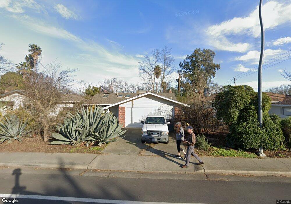
1210 Pole Line Rd Davis, CA 95618
East Davis NeighborhoodEstimated Value: $498,000 - $608,000
3
Beds
1
Bath
1,000
Sq Ft
$549/Sq Ft
Est. Value
About This Home
This home is located at 1210 Pole Line Rd, Davis, CA 95618 and is currently estimated at $549,439, approximately $549 per square foot. 1210 Pole Line Rd is a home located in Yolo County with nearby schools including Birch Lane Elementary School, Oliver Wendell Holmes Junior High School, and Davis Senior High School.
Ownership History
Date
Name
Owned For
Owner Type
Purchase Details
Closed on
Feb 22, 2017
Sold by
Ernisse Don D and Ernisse Judith I
Bought by
Wagner Karen M and Singh Ujvala
Current Estimated Value
Home Financials for this Owner
Home Financials are based on the most recent Mortgage that was taken out on this home.
Original Mortgage
$320,000
Outstanding Balance
$264,127
Interest Rate
4.09%
Mortgage Type
New Conventional
Estimated Equity
$285,312
Purchase Details
Closed on
Sep 25, 2009
Sold by
Andrews Laurence and Andrews Urai
Bought by
Singh Ujvala and Wagner Karen
Home Financials for this Owner
Home Financials are based on the most recent Mortgage that was taken out on this home.
Original Mortgage
$265,470
Interest Rate
5.25%
Mortgage Type
New Conventional
Purchase Details
Closed on
Sep 25, 2002
Sold by
Andrews Larry
Bought by
Andrews Laurence and Andrews Urai
Home Financials for this Owner
Home Financials are based on the most recent Mortgage that was taken out on this home.
Original Mortgage
$256,000
Interest Rate
4.91%
Purchase Details
Closed on
Sep 16, 2002
Sold by
Cunningham Charles W and Dunham Deborah L
Bought by
Andrews Larry
Home Financials for this Owner
Home Financials are based on the most recent Mortgage that was taken out on this home.
Original Mortgage
$256,000
Interest Rate
4.91%
Purchase Details
Closed on
Oct 2, 1995
Sold by
Carbahal Manuel A and Carbahal Debbie R
Bought by
Carbahal Manuel A and Carbahal Debbie R
Home Financials for this Owner
Home Financials are based on the most recent Mortgage that was taken out on this home.
Original Mortgage
$82,600
Interest Rate
7.67%
Purchase Details
Closed on
Sep 30, 1995
Sold by
Dunham Deborah L
Bought by
Cunningham Charles W
Home Financials for this Owner
Home Financials are based on the most recent Mortgage that was taken out on this home.
Original Mortgage
$82,600
Interest Rate
7.67%
Create a Home Valuation Report for This Property
The Home Valuation Report is an in-depth analysis detailing your home's value as well as a comparison with similar homes in the area
Home Values in the Area
Average Home Value in this Area
Purchase History
| Date | Buyer | Sale Price | Title Company |
|---|---|---|---|
| Wagner Karen M | $400,000 | Placer Title Co | |
| Singh Ujvala | $295,000 | Placer Title Company | |
| Andrews Laurence | -- | Fidelity National Title | |
| Andrews Larry | $144,500 | Fidelity National Title | |
| Carbahal Manuel A | -- | Placer Title Company | |
| Cunningham Charles W | -- | Placer Title Company | |
| Andrews Larry | -- | Placer Title Company |
Source: Public Records
Mortgage History
| Date | Status | Borrower | Loan Amount |
|---|---|---|---|
| Open | Wagner Karen M | $320,000 | |
| Previous Owner | Singh Ujvala | $265,470 | |
| Previous Owner | Andrews Laurence | $256,000 | |
| Previous Owner | Carbahal Manuel A | $82,600 |
Source: Public Records
Tax History
| Year | Tax Paid | Tax Assessment Tax Assessment Total Assessment is a certain percentage of the fair market value that is determined by local assessors to be the total taxable value of land and additions on the property. | Land | Improvement |
|---|---|---|---|---|
| 2025 | $5,493 | $380,776 | $167,797 | $212,979 |
| 2023 | $5,493 | $365,991 | $161,282 | $204,709 |
| 2022 | $5,250 | $358,816 | $158,120 | $200,696 |
| 2021 | $5,116 | $351,781 | $155,020 | $196,761 |
| 2020 | $5,029 | $348,175 | $153,431 | $194,744 |
| 2019 | $4,744 | $341,349 | $150,423 | $190,926 |
| 2018 | $4,430 | $334,657 | $147,474 | $187,183 |
| 2017 | $4,333 | $328,096 | $144,583 | $183,513 |
| 2016 | $4,176 | $321,664 | $141,749 | $179,915 |
| 2015 | $4,033 | $316,833 | $139,620 | $177,213 |
| 2014 | $4,033 | $310,628 | $136,886 | $173,742 |
Source: Public Records
Map
Nearby Homes
- 2011 Regis Dr
- 1411 Madrone Ln
- 1501 Madrone Ln
- 2307 E 8th St
- 2505 Loyola Dr
- 1224 Spruce Ln
- 218 Full Cir
- 257 Quarter Cir
- 1001 Ginkgo Cir
- 1007 Ginkgo Cir
- 1013 Ginkgo Cir
- 1107 Baylor Terrace
- 1001 Vanderbilt Terrace
- 1108 Baylor Terrace
- 1007 Vanderbilt Terrace
- 1049 Ginkgo Cir
- 1306 Drexel Dr
- 739 M St
- 103 Full Cir
- 2024 Manet Place
- 1204 Pole Line Rd
- 1216 Pole Line Rd
- 1914 Regis Dr
- 1222 Pole Line Rd
- 2002 Regis Dr
- 1908 Regis Dr
- 1228 Pole Line Rd
- 1114 Snyder Dr
- 1126 Snyder Dr
- 1108 Snyder Dr
- 1200 Snyder Dr
- 1902 Regis Dr
- 1102 Snyder Dr
- 2008 Regis Dr
- 1204 Snyder Dr
- 1026 Snyder Dr
- 1900 Loyola Dr
- 1906 Loyola Dr
- 1912 Loyola Dr
- 1208 Snyder Dr
Your Personal Tour Guide
Ask me questions while you tour the home.