
Seller's Agent in 2024
Cheri White
Coldwell Banker Apex, REALTORS Cleburne
(817) 640-9964
144 Total Sales
Estimated Value: $2,635,039
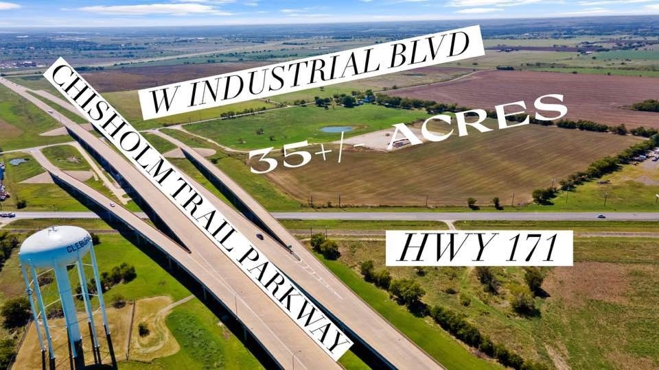
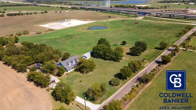
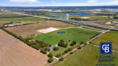
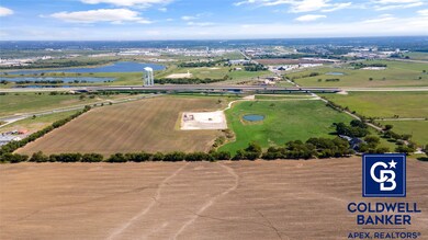
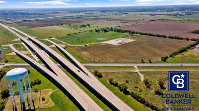
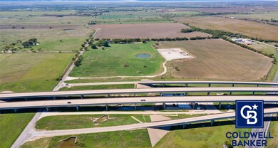
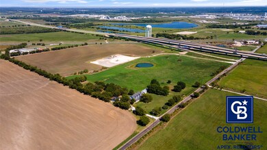
LAND PRIME FOR COMMERCIAL DEVELOPMENT WITH FRONTAGE ON 3 SIDES. NW corner of Chisholm Trail Parkway and W Industrial Blvd. (also known as County Road 1125). Approximately 1116 feet on Chisholm Trail Parkway (east boundary line); approximately 1096 feet on County Road 1125 and Industrial Blvd.; and approximately 503 feet along Highway 171. 1210 and 1222 W Industrial Blvd zoning is SF-7. 1300 CR 1125 zoning is Interim Holding (to be determined). Seller says no production on gas pad for about 2 yrs. Residence is approximately 2,353 square feet and was built in 2009 with 2 detached garages. City water and electric. According to the City of Cleburne, city sewer is coming to the area. Drainage and utilities improvement project in supplemental documents. Properties to be sold together are 1210 & 1222 West Industrial Blvd. and 1300 County Road 1125. Tax ID's for the 4 tracts are 126-0269-00085, 126-0269-00082, 126-0269-00081, and 126-2933-01010. There is an agriculture lease for pasture and crops. Gas company informs that they will reclaim the well early, plug the well and remove all above ground equipment. Amazon announced construction for a new operations facility in Cleburne at the southwest corner of W Industrial Blvd and Chisholm Trail Parkway, which is just south of the subject property. The new facility will be approximately 1.7 million square feet.
Last Agent to Sell the Property
Coldwell Banker Apex, REALTORS Cleburne Brokerage Phone: (214) 546-6414 Listed on: 10/08/2024
Last Buyer's Agent
Non-NTREIS MLS Licensee
NON MLS
| Date | Buyer | Sale Price | Title Company |
|---|---|---|---|
| Lillian Bell Family Partnership Ltd | -- | None Available |
| Date | Event | Price | List to Sale | Price per Sq Ft |
|---|---|---|---|---|
| 05/12/2025 05/12/25 | Sold | -- | -- | -- |
| 01/10/2025 01/10/25 | Pending | -- | -- | -- |
| 10/08/2024 10/08/24 | For Sale | $2,635,200 | -- | -- |
| Year | Tax Paid | Tax Assessment Tax Assessment Total Assessment is a certain percentage of the fair market value that is determined by local assessors to be the total taxable value of land and additions on the property. | Land | Improvement |
|---|---|---|---|---|
| 2025 | $133 | $358,691 | $358,691 | -- |
| 2024 | $133 | $5,984 | $0 | $0 |
| 2023 | $136 | $358,691 | $358,691 | $0 |
| 2022 | $135 | $358,691 | $358,691 | $0 |
| 2021 | $170 | $358,691 | $358,691 | $0 |
| 2020 | $181 | $358,691 | $358,691 | $0 |
| 2019 | $193 | $358,691 | $358,691 | $0 |
| 2018 | $194 | $358,691 | $358,691 | $0 |
| 2017 | $128 | $358,691 | $358,691 | $0 |
| 2016 | $89 | $358,691 | $358,691 | $0 |
| 2015 | $5,087 | $358,691 | $358,691 | $0 |
| 2014 | $5,087 | $0 | $0 | $0 |
Seller's Agent in 2024
Cheri White
Coldwell Banker Apex, REALTORS Cleburne
(817) 640-9964
144 Total Sales
Seller Co-Listing Agent in 2024
Tracy Estes
Coldwell Banker Apex, REALTORS Cleburne
(817) 774-5984
24 Total Sales
N
Buyer's Agent in 2024
Non-NTREIS MLS Licensee
NON MLS
Source: North Texas Real Estate Information Systems (NTREIS)
MLS Number: 20740589
APN: 126-0269-00085
Disclaimer: Certain information contained herein is derived from information provided by parties other than Homes.com. All information provided is deemed reliable, but is not guaranteed to be accurate and should be independently verified.
![]() Listing information provided in part by the North Texas Real Estate Information Systems, Inc, for personal, non-commercial use by viewers of this site and may not be reproduced or redistributed. All information is deemed reliable but not guaranteed. Copyright © NTREIS 2025. All rights reserved
Listing information provided in part by the North Texas Real Estate Information Systems, Inc, for personal, non-commercial use by viewers of this site and may not be reproduced or redistributed. All information is deemed reliable but not guaranteed. Copyright © NTREIS 2025. All rights reserved