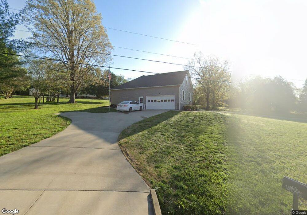
1210 Wesley Ct Lawrenceburg, TN 38464
Estimated Value: $272,000 - $352,000
--
Bed
--
Bath
1,562
Sq Ft
$198/Sq Ft
Est. Value
About This Home
This home is located at 1210 Wesley Ct, Lawrenceburg, TN 38464 and is currently estimated at $309,022, approximately $197 per square foot. 1210 Wesley Ct is a home with nearby schools including Lawrenceburg Public Elementary School, Ingram Sowell Elementary School, and David Crockett Elementary School.
Ownership History
Date
Name
Owned For
Owner Type
Purchase Details
Closed on
Jun 24, 2024
Sold by
Moore Timothy E and Moore Glenda K
Bought by
Moore Family Legacy Trust and Moore
Current Estimated Value
Purchase Details
Closed on
May 17, 2024
Sold by
Moore Timothy E and Moore Glenda K
Bought by
Moore Family Legacy Trust and Moore
Purchase Details
Closed on
May 14, 2018
Sold by
Swindle Zeke and Adkisson Wayne
Bought by
Moore Timothy E and Moore Glenda K
Purchase Details
Closed on
Sep 22, 2010
Bought by
Swindle Zeke & Wayne Adkisson%Buck Building
Purchase Details
Closed on
Sep 17, 1991
Bought by
Swindle Zeke and Swindle Patricia
Purchase Details
Closed on
Feb 2, 1989
Bought by
Dilco Inc
Purchase Details
Closed on
Jan 11, 1989
Bought by
Dilco Inc
Purchase Details
Closed on
Dec 8, 1978
Bought by
Brown Sayles and Brown Louise
Create a Home Valuation Report for This Property
The Home Valuation Report is an in-depth analysis detailing your home's value as well as a comparison with similar homes in the area
Home Values in the Area
Average Home Value in this Area
Purchase History
| Date | Buyer | Sale Price | Title Company |
|---|---|---|---|
| Moore Family Legacy Trust | -- | None Listed On Document | |
| Moore Family Legacy Trust | -- | None Listed On Document | |
| Moore Family Legacy Trust | -- | None Listed On Document | |
| Moore Family Legacy Trust | -- | None Listed On Document | |
| Moore Timothy E | $13,000 | None Available | |
| Swindle Zeke & Wayne Adkisson%Buck Building | -- | -- | |
| Swindle Zeke | -- | -- | |
| Dilco Inc | -- | -- | |
| Dilco Inc | -- | -- | |
| Brown Sayles | -- | -- |
Source: Public Records
Tax History Compared to Growth
Tax History
| Year | Tax Paid | Tax Assessment Tax Assessment Total Assessment is a certain percentage of the fair market value that is determined by local assessors to be the total taxable value of land and additions on the property. | Land | Improvement |
|---|---|---|---|---|
| 2025 | $1,254 | $62,350 | $0 | $0 |
| 2024 | $1,254 | $62,350 | $5,625 | $56,725 |
| 2023 | $1,254 | $62,350 | $5,625 | $56,725 |
| 2022 | $1,254 | $62,350 | $5,625 | $56,725 |
| 2021 | $1,084 | $36,650 | $2,125 | $34,525 |
| 2020 | $1,084 | $36,650 | $2,125 | $34,525 |
| 2019 | $1,084 | $36,650 | $2,125 | $34,525 |
| 2018 | $63 | $36,650 | $2,125 | $34,525 |
| 2017 | $63 | $2,125 | $2,125 | $0 |
| 2016 | $63 | $2,125 | $2,125 | $0 |
| 2015 | $58 | $2,125 | $2,125 | $0 |
| 2014 | $58 | $2,125 | $2,125 | $0 |
Source: Public Records
Map
Nearby Homes
- 1209 Wesley Ct
- 0 Cecile Ct
- 1325 Matthew Ave
- 19 Horseshoe Bend Rd
- 107 Horseshoe Bend Rd
- 12 Horseshoe Bend Rd
- 1876 Fall River Rd
- 34 Baker Ct
- 40 Harding Rd
- 45 Baker Ct
- 1111 Baker Ln
- 1448 Baker Ln
- 1408 Baker Ln
- 1261 Brannon Rd
- 910 Willow Dr
- 33 Bishop Rd
- 107 Pond Dr
- 1122 Brannon Rd
- 123 Quail Dr
- 407 Oakwood Dr
- 1220 Wesley Ct
- 1201 Wesley Ct Unit 19
- 1201 Wesley Ct
- 2115 Wesley Ct
- 1293 Wesley Ct
- 2110 Wesley Ct
- 1299 Wesley Ct
- 1250 Matthew Ave
- 1315 Sayles Cir
- 1225 Matthew Ave
- 1305 Crowder Rd
- 1215 Matthew Ave
- 0 Sayles Cir
- 0 Matthew Ave
- 1325 Sayles Cir
- 1325 Sayles Cir
- 1235 Matthew Ave
- 0 Wesley Ct Unit 1864729
- 1335 Sayles Cir
- 1375 Sayles Cir