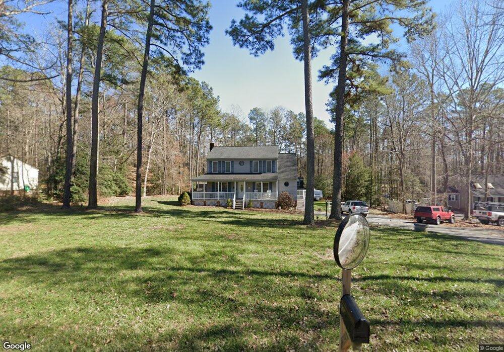
12105 Bundle Rd Chesterfield, VA 23838
South Chesterfield County NeighborhoodEstimated Value: $354,000 - $399,000
3
Beds
3
Baths
1,636
Sq Ft
$230/Sq Ft
Est. Value
About This Home
This home is located at 12105 Bundle Rd, Chesterfield, VA 23838 and is currently estimated at $375,735, approximately $229 per square foot. 12105 Bundle Rd is a home located in Chesterfield County with nearby schools including Matoaca Elementary School, Bailey Bridge Middle School, and Matoaca High School.
Ownership History
Date
Name
Owned For
Owner Type
Purchase Details
Closed on
Jun 7, 2001
Bought by
Gilbert William T and Gilbert Kimberly A
Current Estimated Value
Home Financials for this Owner
Home Financials are based on the most recent Mortgage that was taken out on this home.
Original Mortgage
$20,000
Outstanding Balance
$7,585
Interest Rate
7.08%
Mortgage Type
New Conventional
Estimated Equity
$368,150
Create a Home Valuation Report for This Property
The Home Valuation Report is an in-depth analysis detailing your home's value as well as a comparison with similar homes in the area
Home Values in the Area
Average Home Value in this Area
Purchase History
| Date | Buyer | Sale Price | Title Company |
|---|---|---|---|
| Gilbert William T | -- | -- |
Source: Public Records
Mortgage History
| Date | Status | Borrower | Loan Amount |
|---|---|---|---|
| Open | Gilbert William T | $20,000 |
Source: Public Records
Tax History
| Year | Tax Paid | Tax Assessment Tax Assessment Total Assessment is a certain percentage of the fair market value that is determined by local assessors to be the total taxable value of land and additions on the property. | Land | Improvement |
|---|---|---|---|---|
| 2025 | $2,783 | $309,900 | $68,300 | $241,600 |
| 2024 | $2,783 | $300,500 | $66,300 | $234,200 |
| 2023 | $2,573 | $282,700 | $62,300 | $220,400 |
| 2022 | $2,328 | $253,000 | $59,300 | $193,700 |
| 2021 | $2,237 | $232,800 | $57,300 | $175,500 |
| 2020 | $2,169 | $228,300 | $57,300 | $171,000 |
| 2019 | $2,058 | $216,600 | $55,300 | $161,300 |
| 2018 | $2,010 | $211,600 | $53,200 | $158,400 |
| 2017 | $1,968 | $205,000 | $52,200 | $152,800 |
| 2016 | $1,903 | $198,200 | $51,200 | $147,000 |
| 2015 | $1,838 | $191,500 | $50,200 | $141,300 |
| 2014 | $1,790 | $186,500 | $50,200 | $136,300 |
Source: Public Records
Map
Nearby Homes
- 12018 Eagle Pass Dr
- 12079 Goldenbrook Dr
- 12117 River Rd
- 18612 Holly Crest Dr
- 13424 Janeka Dr
- 11918 Brook Point Place
- 12418 Nash Rd
- 8825 First Branch Ln
- 10830 Egret Ct
- 11630 Barrows Ridge Ln
- 11965 River Rd
- 13421 Carters Way Rd
- 10220 Reedy Branch Rd
- 11940 Nash Rd
- 13201 Derryveach Dr
- 12018 Buckrudy Terrace
- 9933 Third Branch Dr
- 11925 Dunvegan Ct
- 8543 Brechin Ln
- 13630 River Rd
- 12101 Bundle Rd
- 12109 Bundle Rd
- 12031 Bundle Rd
- 12060 Hunters Hawk Ct
- 12050 Hunters Hawk Ct
- 12113 Bundle Rd
- 12080 Hunters Hawk Ct
- 12021 Bundle Rd
- 12040 Hunters Hawk Ct
- 12117 Bundle Rd
- 12110 Bundle Rd
- 12010 Bundle Rd
- 12100 Bundle Rd
- 12121 Bundle Rd
- 12030 Hunters Hawk Ct
- 12081 Hunters Hawk Ct
- 12071 Hunters Hawk Ct
- 12051 Hunters Hawk Ct
- 12000 Bundle Rd
- 12011 Bundle Rd
Your Personal Tour Guide
Ask me questions while you tour the home.