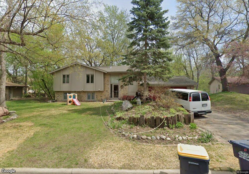
12118 Red Oak Ct S Burnsville, MN 55337
Estimated Value: $403,536 - $409,000
4
Beds
3
Baths
1,184
Sq Ft
$343/Sq Ft
Est. Value
About This Home
This home is located at 12118 Red Oak Ct S, Burnsville, MN 55337 and is currently estimated at $406,134, approximately $343 per square foot. 12118 Red Oak Ct S is a home located in Dakota County with nearby schools including William Byrne Elementary School, Burnsville High School, and Gateway STEM Academy.
Ownership History
Date
Name
Owned For
Owner Type
Purchase Details
Closed on
Apr 23, 2013
Sold by
Voight Joel Daniel and Voight Jessica C
Bought by
Voight Joel Daniel and Voight Jessica C
Current Estimated Value
Home Financials for this Owner
Home Financials are based on the most recent Mortgage that was taken out on this home.
Original Mortgage
$146,000
Outstanding Balance
$103,243
Interest Rate
3.51%
Mortgage Type
New Conventional
Estimated Equity
$302,891
Purchase Details
Closed on
Mar 16, 2001
Sold by
Ramstad Peter M and Ramstad Janice L
Bought by
Voight Joel Daniel
Create a Home Valuation Report for This Property
The Home Valuation Report is an in-depth analysis detailing your home's value as well as a comparison with similar homes in the area
Home Values in the Area
Average Home Value in this Area
Purchase History
| Date | Buyer | Sale Price | Title Company |
|---|---|---|---|
| Voight Joel Daniel | -- | Nations Title Agency Of Minn | |
| Voight Joel Daniel | $125,000 | -- |
Source: Public Records
Mortgage History
| Date | Status | Borrower | Loan Amount |
|---|---|---|---|
| Open | Voight Joel Daniel | $146,000 |
Source: Public Records
Tax History Compared to Growth
Tax History
| Year | Tax Paid | Tax Assessment Tax Assessment Total Assessment is a certain percentage of the fair market value that is determined by local assessors to be the total taxable value of land and additions on the property. | Land | Improvement |
|---|---|---|---|---|
| 2024 | $3,990 | $381,600 | $97,800 | $283,800 |
| 2023 | $3,990 | $381,300 | $97,900 | $283,400 |
| 2022 | $3,208 | $354,700 | $97,700 | $257,000 |
| 2021 | $3,100 | $305,900 | $85,000 | $220,900 |
| 2020 | $3,190 | $282,200 | $80,900 | $201,300 |
| 2019 | $3,150 | $279,800 | $77,100 | $202,700 |
| 2018 | $2,925 | $264,200 | $73,400 | $190,800 |
| 2017 | $2,832 | $240,500 | $69,900 | $170,600 |
| 2016 | $2,964 | $230,100 | $66,600 | $163,500 |
| 2015 | $2,653 | $214,441 | $59,995 | $154,446 |
| 2014 | -- | $199,944 | $58,256 | $141,688 |
| 2013 | -- | $180,542 | $52,500 | $128,042 |
Source: Public Records
Map
Nearby Homes
- 3309 Red Oak Cir N
- 319 River Woods Ln
- 4632 Westwood Ln
- 221 River Woods Ln
- 247 River Woods Ln
- 4774 Slater Rd
- 11902 River Hills Cir
- 188 River Woods Ln
- 145 River Woods Ln
- 146 River Woods Ln
- 11921 Baypoint Dr
- 72 River Woods Ln
- 55 River Woods Ln
- 11900 Highland View Cir
- 3017 Mcleod St
- 2100 Viburnum Trail
- 2107 Kings Rd
- 12625 Sable Dr
- 4463 Cinnamon Ridge Cir
- 12640 Tiffany Ct
- 12120 Red Oak Ct S
- 12116 Red Oak Ct S
- 4751 White Oak Ct
- 4757 White Oak Ct
- 4745 White Oak Ct
- 12122 Red Oak Ct S
- 12117 Red Oak Ct S
- 12114 Red Oak Ct S
- 4763 White Oak Ct
- 4739 White Oak Ct
- 12113 Red Oak Ct S
- 4769 White Oak Ct
- 12124 Red Oak Ct S
- 12112 Red Oak Ct S
- 4733 White Oak Ct
- 12121 Red Oak Ct S
- 4748 White Oak Ct
- 4756 White Oak Ct
- 12109 Red Oak Ct S
- 12126 Red Oak Ct S