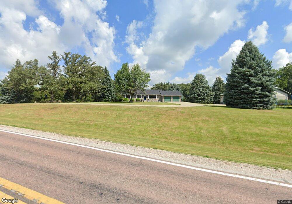
1212 W Highway 37 Dunlap, IA 51529
Estimated Value: $286,000 - $466,000
2
Beds
2
Baths
1,456
Sq Ft
$256/Sq Ft
Est. Value
About This Home
This home is located at 1212 W Highway 37, Dunlap, IA 51529 and is currently estimated at $372,140, approximately $255 per square foot. 1212 W Highway 37 is a home located in Crawford County with nearby schools including Boyer Valley Elementary School and Boyer Valley Middle/High School.
Ownership History
Date
Name
Owned For
Owner Type
Purchase Details
Closed on
Dec 2, 2020
Sold by
Kevin Vander Kolk and Kevin Tammie L
Bought by
Carey Michael W and Carey Tammy Jo
Current Estimated Value
Create a Home Valuation Report for This Property
The Home Valuation Report is an in-depth analysis detailing your home's value as well as a comparison with similar homes in the area
Home Values in the Area
Average Home Value in this Area
Purchase History
| Date | Buyer | Sale Price | Title Company |
|---|---|---|---|
| Carey Michael W | $280,000 | Frisk Judson L |
Source: Public Records
Tax History Compared to Growth
Tax History
| Year | Tax Paid | Tax Assessment Tax Assessment Total Assessment is a certain percentage of the fair market value that is determined by local assessors to be the total taxable value of land and additions on the property. | Land | Improvement |
|---|---|---|---|---|
| 2025 | $3,702 | $314,870 | $36,350 | $278,520 |
| 2024 | $3,702 | $309,360 | $36,350 | $273,010 |
| 2023 | $3,506 | $309,360 | $36,350 | $273,010 |
| 2022 | $3,460 | $254,020 | $36,350 | $217,670 |
| 2021 | $2,852 | $254,020 | $36,350 | $217,670 |
| 2020 | $2,806 | $196,230 | $25,450 | $170,780 |
| 2019 | $2,656 | $182,400 | $15,450 | $166,950 |
| 2018 | $2,622 | $182,400 | $15,450 | $166,950 |
| 2017 | $2,622 | $182,400 | $15,450 | $166,950 |
| 2016 | $2,740 | $181,360 | $0 | $0 |
| 2015 | $2,740 | $160,080 | $0 | $0 |
| 2014 | $2,368 | $160,080 | $0 | $0 |
Source: Public Records
Map
Nearby Homes
- 202 Y St
- 1403 Eaton St
- 32055 Spruce Ave
- 211 Brookview Dr
- 2074 U Ave
- 39472 280th St
- 37 10th St
- 808 Park St
- 907 Harvest Hills Dr
- 102 Bluegrass Ln
- 101 Bluegrass Ln
- 42 6th St
- 106 Bluegrass Ln
- 905 Harvest Hills Dr
- 111 Ridgeline Rd
- 906 Harvest Hills Dr
- 903 Harvest Hills Dr
- 118 Ridgeline Rd
- 904 Harvest Hills Dr
- 1222 W Highway 37
- 1221 W Highway 37
- 1208 W Highway 37
- 1224 W Highway 37
- 1205 W Highway 37
- 1224 Iowa 37
- 1192 W Highway 37
- 1192 W Highway 37
- 1189 Hwy 37
- 1029 Tabor Ave
- 3381 130th St
- 1139 Nelson Hollow
- 3391 130th St
- 3337 130th St
- 1141 W Highway 37
- 1128 Nelson Hollow
- 3327 130th St
- 1131 Nelson Hollow
- 3489 340th St
- 1107 Street