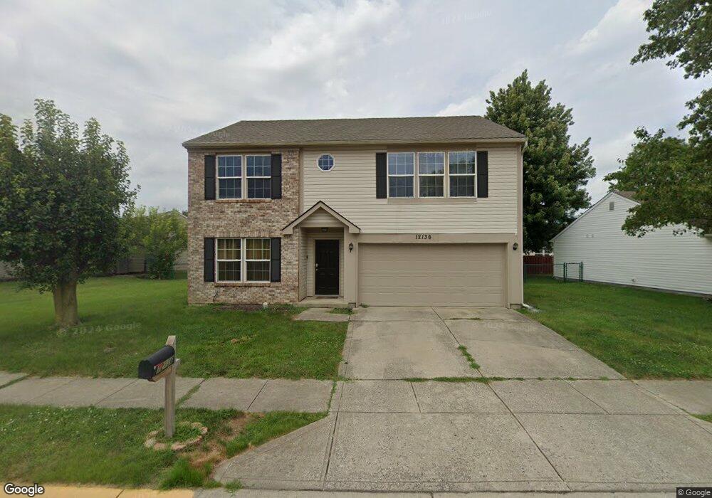
12136 Bearsdale Dr Indianapolis, IN 46235
Estimated Value: $254,455 - $280,000
Studio
2
Baths
1,976
Sq Ft
$135/Sq Ft
Est. Value
About This Home
This home is located at 12136 Bearsdale Dr, Indianapolis, IN 46235 and is currently estimated at $266,614, approximately $134 per square foot. 12136 Bearsdale Dr is a home located in Marion County with nearby schools including Oaklandon Elementary School, Belzer Middle School, and Lawrence Central High School.
Ownership History
Date
Name
Owned For
Owner Type
Purchase Details
Closed on
Jan 27, 2020
Sold by
Simple Quarters Llc
Bought by
Sfr Jv & 1 Property Llc
Current Estimated Value
Home Financials for this Owner
Home Financials are based on the most recent Mortgage that was taken out on this home.
Original Mortgage
$103,000
Outstanding Balance
$89,824
Interest Rate
3.6%
Mortgage Type
Commercial
Estimated Equity
$176,790
Purchase Details
Closed on
Dec 30, 2019
Sold by
Madison Jim T and Madison Lorrilynn R
Bought by
Simple Quarters Llc
Home Financials for this Owner
Home Financials are based on the most recent Mortgage that was taken out on this home.
Original Mortgage
$103,000
Outstanding Balance
$89,824
Interest Rate
3.6%
Mortgage Type
Commercial
Estimated Equity
$176,790
Create a Home Valuation Report for This Property
The Home Valuation Report is an in-depth analysis detailing your home's value as well as a comparison with similar homes in the area
Home Values in the Area
Average Home Value in this Area
Purchase History
| Date | Buyer | Sale Price | Title Company |
|---|---|---|---|
| Sfr Jv & 1 Property Llc | $135,000 | None Available | |
| Simple Quarters Llc | $106,329 | Hocker Title |
Source: Public Records
Mortgage History
| Date | Status | Borrower | Loan Amount |
|---|---|---|---|
| Open | Simple Quarters Llc | $103,000 |
Source: Public Records
Tax History
| Year | Tax Paid | Tax Assessment Tax Assessment Total Assessment is a certain percentage of the fair market value that is determined by local assessors to be the total taxable value of land and additions on the property. | Land | Improvement |
|---|---|---|---|---|
| 2025 | $5,007 | $259,500 | $29,800 | $229,700 |
| 2024 | $5,036 | $229,900 | $29,800 | $200,100 |
| 2023 | $5,036 | $229,900 | $29,800 | $200,100 |
| 2022 | $4,678 | $211,500 | $29,800 | $181,700 |
| 2021 | $3,876 | $172,800 | $29,800 | $143,000 |
| 2020 | $1,695 | $150,100 | $21,000 | $129,100 |
| 2019 | $1,566 | $153,400 | $21,000 | $132,400 |
| 2018 | $1,462 | $143,100 | $21,000 | $122,100 |
| 2017 | $1,356 | $132,600 | $21,000 | $111,600 |
| 2016 | $1,283 | $125,400 | $21,000 | $104,400 |
| 2014 | $1,079 | $117,200 | $21,000 | $96,200 |
| 2013 | $1,101 | $117,200 | $21,000 | $96,200 |
Source: Public Records
Map
Nearby Homes
- 12414 Bearsdale Dr
- 12431 Teacup Way
- 6614 Sparrowood Dr
- 12509 Teacup Way
- 11845 Railroad St
- 6376 Village Oak Ct
- 12710 White Rabbit Dr
- 11640 E 63rd St
- 11805 E 62nd St
- 11965 Cable Dr
- 6905 W Wintergreen Ct
- 6873 W Cedarwood Cir
- 6909 Copper Mountain Ct
- 6615 Aberdeen Dr
- 6986 Birmingham Ave
- 6819 W Wintergreen Ct
- 5809 Terracotta Trace
- 5844 Cherrywood Ln
- 6179 N Cedarwood Dr
- 6603 Laredo Dr
- 6305 Blakeview Dr
- 12148 Bearsdale Dr
- 12211 Meadowfield Cir
- 12205 Meadowfield Cir
- 6311 Blakeview Dr
- 12154 Bearsdale Dr
- 12139 Bearsdale Dr
- 12133 Bearsdale Dr
- 12145 Bearsdale Dr
- 12145 Bearsdale Dr
- 12145 Bearsdale Dr Unit 98
- 12217 Meadowfield Cir
- 12204 Meadowfield Cir
- 6317 Blakeview Dr
- 12206 Bearsdale Dr
- 12123 Bearsdale Dr
- 6341 Meadowpond Way
- 12203 Bearsdale Dr
- 12223 Meadowfield Cir
- 6318 Blakeview Dr
Your Personal Tour Guide
Ask me questions while you tour the home.