Estimated Value: $201,545 - $218,000
3
Beds
2
Baths
1,536
Sq Ft
$136/Sq Ft
Est. Value
About This Home
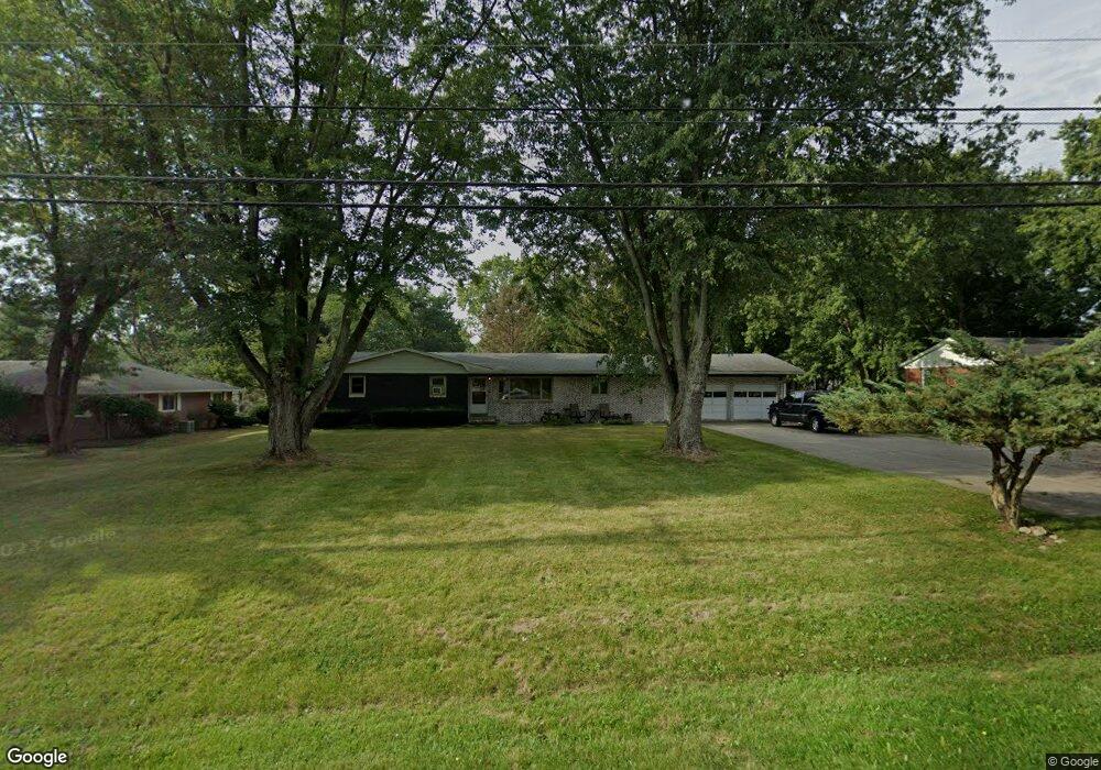
This home is located at 12136 State Route 34, Bryan, OH 43506 and is currently estimated at $208,386, approximately $135 per square foot. 12136 State Route 34 is a home located in Williams County with nearby schools including Bryan Elementary PK-5, Washington Elementary School, and Bryan Middle School/High School.
Ownership History
Date
Name
Owned For
Owner Type
Purchase Details
Closed on
Aug 13, 2004
Bought by
Mccarty Christopher L
Current Estimated Value
Purchase Details
Closed on
Aug 20, 1996
Sold by
Lirot Lavon and Lirot Donna
Bought by
Lirot Lavon Trust Lirot Larry Trustee
Purchase Details
Closed on
Jan 1, 1990
Bought by
Lirot Lavon and Lirot Donna
Create a Home Valuation Report for This Property
The Home Valuation Report is an in-depth analysis detailing your home's value as well as a comparison with similar homes in the area
Purchase History
| Date | Buyer | Sale Price | Title Company |
|---|---|---|---|
| Mccarty Christopher L | $115,900 | -- | |
| Lirot Lavon Trust Lirot Larry Trustee | -- | -- | |
| Lirot Lavon | -- | -- |
Source: Public Records
Tax History
| Year | Tax Paid | Tax Assessment Tax Assessment Total Assessment is a certain percentage of the fair market value that is determined by local assessors to be the total taxable value of land and additions on the property. | Land | Improvement |
|---|---|---|---|---|
| 2025 | $2,568 | $57,790 | $9,770 | $48,020 |
| 2024 | $2,568 | $57,790 | $9,770 | $48,020 |
| 2023 | $2,593 | $49,040 | $9,940 | $39,100 |
| 2022 | $2,444 | $49,040 | $9,940 | $39,100 |
| 2021 | $2,444 | $49,040 | $9,940 | $39,100 |
| 2020 | $2,160 | $41,940 | $8,510 | $33,430 |
| 2019 | $2,147 | $41,940 | $8,510 | $33,430 |
| 2018 | $2,143 | $41,940 | $8,510 | $33,430 |
| 2017 | $1,841 | $36,270 | $8,510 | $27,760 |
| 2016 | $1,758 | $36,270 | $8,510 | $27,760 |
| 2015 | $1,836 | $36,270 | $8,510 | $27,760 |
| 2014 | $1,836 | $36,270 | $8,510 | $27,760 |
| 2013 | $1,843 | $36,270 | $8,510 | $27,760 |
Source: Public Records
Map
Nearby Homes
- 144 Deerfield Cir
- 125 Turnberry Dr
- 916 Navarre Ave
- 13673 County Rd E Unit 10
- 00 Troon Ct
- 202 Belfast Ln
- 0 Saint Andrews Dr
- 723 W High St
- 1001 Greystone Dr
- 324 Dublin Ln
- 322 Dublin Ln
- 12341 County Road C
- 101 Westview St
- 630 Center Ridge Rd
- 425 Oakwood Ave
- 412 Center St
- 228 N Beech St
- 128 N Beech St
- 0 Lynn St Unit 6110702
- 542 S Beech St
- 12116 State Route 34
- 12156 State Route 34
- 205 Center Cir
- 207 Center Cir
- 103 Ford Rd
- 12082 State Route 34
- 12082 St Rt 34
- 209 Center Cir
- 12169 State Route 34
- 12169 State Route 34
- 12169 Ohio 34
- 106 Sam Anna Dr
- 102 Ford Rd
- 206 Center Cir
- 208 Center Cir
- 204 Center Cir
- 202 Center Cir
- 105 Sam Anna Dr
- 104 Ford Rd
- 107 Sam Anna Dr
Your Personal Tour Guide
Ask me questions while you tour the home.