S
Seller's Agent in 2025
Scott Linnemeyer
Beacon Street Properties, LLC
(573) 289-6860
82 Total Sales
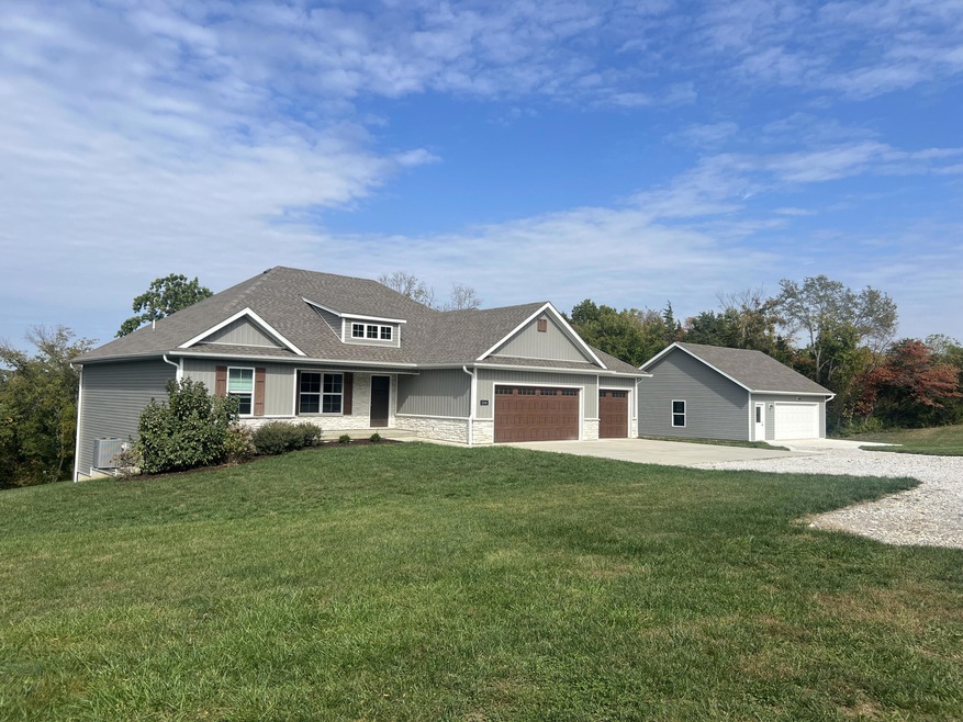
Welcome to your stunning country retreat in Southwest Columbia! Nestled on 2.5 acres with gorgeous wooded views, this extraordinary two-level home is designed for both comfortable living and family entertaining. Featuring 4 spacious bedrooms, 3 full bathrooms, separate laundry room, charming mud room, an attached 3-car garage and detached 30'x 30' shop, this home offers ample space for family and guests. Step outside to enjoy your covered deck overlooking the huge yard and beautiful views - an ideal setting for three season relaxation. Inside, you'll find laminate wood floors, a chef's kitchen outfitted with Samsung appliances including a gas range and walk-in pantry, a sunlit dining room, and a great room complete with a vaulted ceiling. When it's time to unwind, retreat to your primary suite, featuring a built-in lighted headboard, custom spa shower and a spacious walk-in closet. The finished walk-out basement includes a cozy gas fireplace with stone surround, a custom wet bar area along with a private bedroom suite and plenty of storage. This is a rare opportunity to live a country lifestyle with desirable schools in Southwest Columbia - don't miss it!
Last Agent to Sell the Property
Beacon Street Properties, LLC License #2006018121 Listed on: 10/16/2025
| Date | Type | Sale Price | Title Company |
|---|---|---|---|
| Warranty Deed | -- | Boone Central Title | |
| Warranty Deed | -- | Boone Central Title | |
| Warranty Deed | -- | Boone Central Title |
| Date | Status | Loan Amount | Loan Type |
|---|---|---|---|
| Open | $531,000 | New Conventional | |
| Previous Owner | $555,000 | Credit Line Revolving |
| Date | Event | Price | List to Sale | Price per Sq Ft |
|---|---|---|---|---|
| 12/05/2025 12/05/25 | Sold | -- | -- | -- |
| 11/06/2025 11/06/25 | Pending | -- | -- | -- |
| 10/16/2025 10/16/25 | For Sale | $599,900 | -- | $224 / Sq Ft |
| Year | Tax Paid | Tax Assessment Tax Assessment Total Assessment is a certain percentage of the fair market value that is determined by local assessors to be the total taxable value of land and additions on the property. | Land | Improvement |
|---|---|---|---|---|
| 2025 | $4,846 | $72,998 | $7,600 | $65,398 |
| 2024 | $4,533 | $66,367 | $7,600 | $58,767 |
| 2023 | $4,499 | $66,367 | $7,600 | $58,767 |
| 2022 | $1,297 | $19,152 | $7,600 | $11,552 |
| 2021 | $516 | $7,600 | $7,600 | $0 |
S
Seller's Agent in 2025
Scott Linnemeyer
Beacon Street Properties, LLC
(573) 289-6860
82 Total Sales
L
Seller Co-Listing Agent in 2025
Lyle Mann
Beacon Street Properties, LLC
(573) 864-8282
71 Total Sales
J
Buyer's Agent in 2025
Jen McCallister
573 Realty, LLC
(573) 999-3983
189 Total Sales
Source: Columbia Board of REALTORS®
MLS Number: 430397
APN: 20-900-36-02-001-01
Disclaimer: Certain information contained herein is derived from information provided by parties other than Homes.com. All information provided is deemed reliable, but is not guaranteed to be accurate and should be independently verified.
![]() IDX information is provided exclusively for personal, non-commercial use, and may not be used for any purpose other than to identify prospective properties consumers may be interested in purchasing. Information is deemed reliable but not guaranteed.
IDX information is provided exclusively for personal, non-commercial use, and may not be used for any purpose other than to identify prospective properties consumers may be interested in purchasing. Information is deemed reliable but not guaranteed.
Ask me questions while you tour the home.
