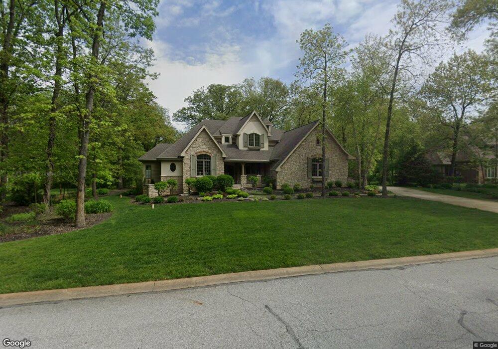
12147 S Williams Ct Crown Point, IN 46307
Estimated Value: $625,000 - $708,000
4
Beds
4
Baths
3,557
Sq Ft
$190/Sq Ft
Est. Value
About This Home
This home is located at 12147 S Williams Ct, Crown Point, IN 46307 and is currently estimated at $675,460, approximately $189 per square foot. 12147 S Williams Ct is a home located in Lake County with nearby schools including Lake Street Elementary School, Robert Taft Middle School, and Crown Point High School.
Ownership History
Date
Name
Owned For
Owner Type
Purchase Details
Closed on
Jul 11, 2017
Sold by
Randolph Daniel W and Randolph Robbie S
Bought by
Daniel And Robble Randolph Living Trust
Current Estimated Value
Purchase Details
Closed on
Aug 31, 2005
Sold by
Means Iii Jay A and Means Mary E
Bought by
Randolph Daniel W and Randolph Robbie S
Home Financials for this Owner
Home Financials are based on the most recent Mortgage that was taken out on this home.
Original Mortgage
$359,600
Interest Rate
5.89%
Mortgage Type
Fannie Mae Freddie Mac
Create a Home Valuation Report for This Property
The Home Valuation Report is an in-depth analysis detailing your home's value as well as a comparison with similar homes in the area
Home Values in the Area
Average Home Value in this Area
Purchase History
| Date | Buyer | Sale Price | Title Company |
|---|---|---|---|
| Daniel And Robble Randolph Living Trust | -- | None Available | |
| Randolph Daniel W | -- | Ticor |
Source: Public Records
Mortgage History
| Date | Status | Borrower | Loan Amount |
|---|---|---|---|
| Closed | Randolph Daniel W | $359,600 |
Source: Public Records
Tax History Compared to Growth
Tax History
| Year | Tax Paid | Tax Assessment Tax Assessment Total Assessment is a certain percentage of the fair market value that is determined by local assessors to be the total taxable value of land and additions on the property. | Land | Improvement |
|---|---|---|---|---|
| 2024 | $12,175 | $615,000 | $55,400 | $559,600 |
| 2023 | $6,015 | $572,900 | $55,400 | $517,500 |
| 2022 | $6,015 | $545,300 | $55,400 | $489,900 |
| 2021 | $5,519 | $526,200 | $55,400 | $470,800 |
| 2020 | $5,813 | $525,100 | $55,400 | $469,700 |
| 2019 | $5,632 | $501,100 | $55,400 | $445,700 |
| 2018 | $5,754 | $485,600 | $55,400 | $430,200 |
| 2017 | $6,290 | $520,900 | $55,400 | $465,500 |
| 2016 | $6,433 | $528,700 | $55,400 | $473,300 |
| 2014 | $6,343 | $550,100 | $55,400 | $494,700 |
| 2013 | $6,186 | $537,600 | $55,400 | $482,200 |
Source: Public Records
Map
Nearby Homes
- 4714 W 121st Ave
- 1144 Mary Ellen Dr
- 1156 Donegal Ln
- 1140 Hyde Park
- 3709 W 121st Ave
- 775 Quinlan Ct
- 804 Shannon Dr
- 12120 Burr St
- 802 Hayfield Dr
- 908 Mary Ellen Dr
- 11606 Westvalley Dr
- 12201 Cedar Lake Rd
- 11531 Westvalley Dr
- 1575 S Feather Rock Dr
- 12860 Baker Ct
- 12812 Whitcomb St
- 12715 Cedar Lake Rd
- 1002 Gordon Ct
- 11341 Lakewood St
- The Cottonwood Plan at Golden Meadow
- 12131 S Williams Ct
- 12152 S Williams Ct
- 12188 S Williams Ct
- 12179 S Williams Ct
- 12115 S Williams Ct
- 4607 W 121st Ave
- 12136 S Williams Ct
- 4557 W 121st Ave
- 12120 S Williams Ct
- 12195 S Williams Ct
- 4655 W 121st Ave
- 4710 W 122nd Place
- 4501 W 121st Ave
- 4730 W 122nd Place
- 4690 W 122nd Place
- 4736 W 122nd Place
- 12227 S Williams Ct
- 12175 Clark St
- 12151 Clark St
- 12201 Clark St