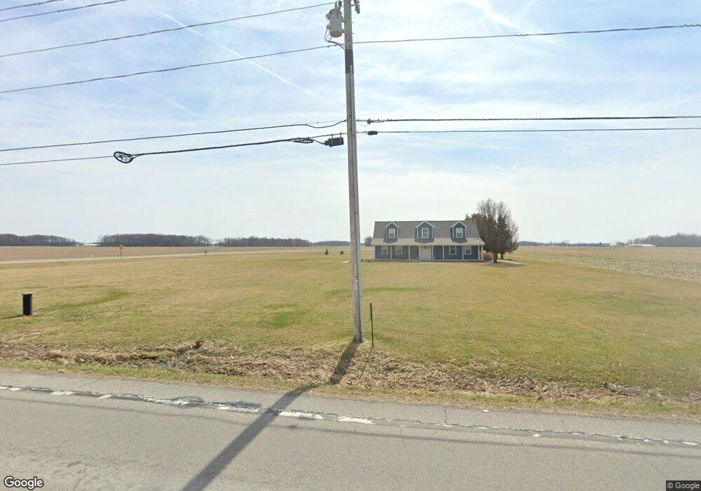
1215 State Route 103 Bluffton, OH 45817
Estimated Value: $264,000 - $460,000
3
Beds
3
Baths
1,785
Sq Ft
$195/Sq Ft
Est. Value
About This Home
This home is located at 1215 State Route 103, Bluffton, OH 45817 and is currently estimated at $348,598, approximately $195 per square foot. 1215 State Route 103 is a home located in Hancock County with nearby schools including Cory-Rawson Elementary School and Cory-Rawson High School.
Ownership History
Date
Name
Owned For
Owner Type
Purchase Details
Closed on
Aug 11, 2020
Sold by
Badertscher Ryan A and Badertscher Karis M
Bought by
Martin Timothy and Martin Natasha
Current Estimated Value
Home Financials for this Owner
Home Financials are based on the most recent Mortgage that was taken out on this home.
Original Mortgage
$220,000
Outstanding Balance
$195,155
Interest Rate
3%
Mortgage Type
New Conventional
Estimated Equity
$153,443
Purchase Details
Closed on
May 11, 2011
Sold by
Citizens National Bank Of Bluffton
Bought by
Baderscher Ryan A and Baderscher Karis M
Home Financials for this Owner
Home Financials are based on the most recent Mortgage that was taken out on this home.
Original Mortgage
$125,800
Interest Rate
4.88%
Mortgage Type
New Conventional
Purchase Details
Closed on
Jun 15, 2010
Sold by
Raines Michael S
Bought by
The Citizens National Bank Of Bluffton
Create a Home Valuation Report for This Property
The Home Valuation Report is an in-depth analysis detailing your home's value as well as a comparison with similar homes in the area
Purchase History
| Date | Buyer | Sale Price | Title Company |
|---|---|---|---|
| Martin Timothy | $234,000 | Black Hoof Title | |
| Baderscher Ryan A | $132,500 | Blackhoof Title Agency | |
| The Citizens National Bank Of Bluffton | $83,334 | Attorney |
Source: Public Records
Mortgage History
| Date | Status | Borrower | Loan Amount |
|---|---|---|---|
| Open | Martin Timothy | $220,000 | |
| Closed | Baderscher Ryan A | $125,800 |
Source: Public Records
Tax History
| Year | Tax Paid | Tax Assessment Tax Assessment Total Assessment is a certain percentage of the fair market value that is determined by local assessors to be the total taxable value of land and additions on the property. | Land | Improvement |
|---|---|---|---|---|
| 2024 | $2,551 | $82,660 | $8,840 | $73,820 |
| 2023 | $2,542 | $82,660 | $8,840 | $73,820 |
| 2022 | $2,554 | $82,660 | $8,840 | $73,820 |
| 2021 | $2,497 | $73,290 | $8,810 | $64,480 |
| 2020 | $2,500 | $73,290 | $8,810 | $64,480 |
| 2019 | $2,440 | $73,290 | $8,810 | $64,480 |
| 2018 | $2,115 | $66,280 | $7,660 | $58,620 |
| 2017 | $1,059 | $66,280 | $7,660 | $58,620 |
| 2016 | $2,121 | $66,280 | $7,660 | $58,620 |
| 2015 | $1,726 | $57,540 | $7,660 | $49,880 |
| 2014 | $1,743 | $57,540 | $7,660 | $49,880 |
| 2012 | $1,827 | $55,160 | $7,660 | $47,500 |
Source: Public Records
Map
Nearby Homes
- 408 Cherry St
- 20515 County Road 15
- 328 N Main St
- 0 Ohio 103
- 106 Riley St
- 210 N Jackson St
- 307 S Main St Unit back
- 222 N Lawn Ave
- 218 S Jackson St
- 217 Grove St
- 513 S Jackson St
- 301 Parkview Dr
- 303 Parkview Dr
- 305 Parkview Dr
- 307 Parkview Dr
- 315 Parkview Dr
- 317 Parkview Dr
- 319 Parkview Dr
- 321 Parkview Dr
- 327 Parkview Dr
- 320 Coyote Trail
- 284 Coyote Trail
- 764 County Road 29
- 675 County Road 29
- 0 Township Road 51
- 000 Township Road 51
- 1310 County Road 29
- 0 Navajo Dr
- 20073 Township Road 51
- 604 County Road 29
- 599 County Road 29
- 851 State Route
- 851 State Route 103
- 851 Sr
- 851 Ohio 103
- 596 Cr
- 596 County Rd
- 855 Ohio 103
- 1465 State Route
Your Personal Tour Guide
Ask me questions while you tour the home.