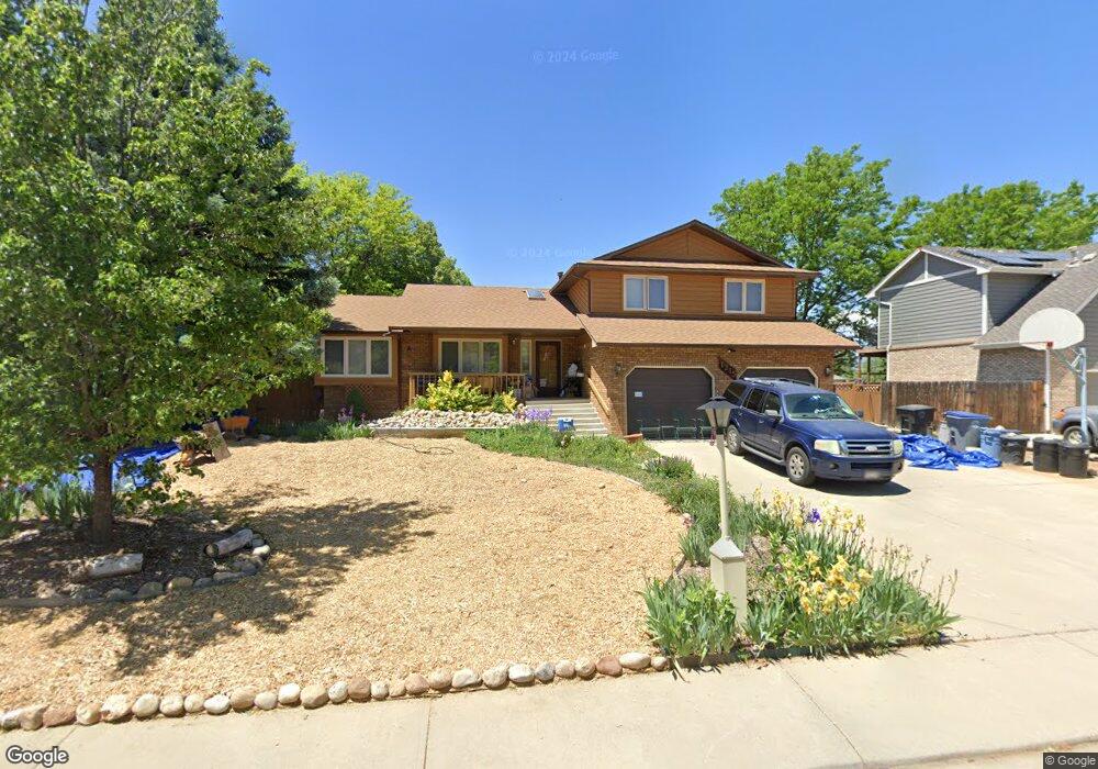
1215 Twin Peaks Cir Longmont, CO 80503
Longmont Estates NeighborhoodEstimated Value: $626,398 - $700,000
3
Beds
3
Baths
2,164
Sq Ft
$312/Sq Ft
Est. Value
About This Home
This home is located at 1215 Twin Peaks Cir, Longmont, CO 80503 and is currently estimated at $674,850, approximately $311 per square foot. 1215 Twin Peaks Cir is a home located in Boulder County with nearby schools including Longmont Estates Elementary School, Westview Middle School, and Silver Creek High School.
Ownership History
Date
Name
Owned For
Owner Type
Purchase Details
Closed on
Mar 4, 1987
Bought by
Kantrowitz Hal M and Kantrowitz Irene J
Current Estimated Value
Purchase Details
Closed on
Oct 17, 1986
Bought by
Kantrowitz Hal M and Kantrowitz Irene J
Purchase Details
Closed on
Jul 10, 1984
Bought by
Kantrowitz Hal M and Kantrowitz Irene J
Purchase Details
Closed on
Nov 25, 1983
Bought by
Kantrowitz Hal M and Kantrowitz Irene J
Create a Home Valuation Report for This Property
The Home Valuation Report is an in-depth analysis detailing your home's value as well as a comparison with similar homes in the area
Home Values in the Area
Average Home Value in this Area
Purchase History
| Date | Buyer | Sale Price | Title Company |
|---|---|---|---|
| Kantrowitz Hal M | $155,700 | -- | |
| Kantrowitz Hal M | $28,000 | -- | |
| Kantrowitz Hal M | -- | -- | |
| Kantrowitz Hal M | -- | -- |
Source: Public Records
Tax History Compared to Growth
Tax History
| Year | Tax Paid | Tax Assessment Tax Assessment Total Assessment is a certain percentage of the fair market value that is determined by local assessors to be the total taxable value of land and additions on the property. | Land | Improvement |
|---|---|---|---|---|
| 2025 | $2,840 | $36,769 | $9,538 | $27,231 |
| 2024 | $2,840 | $36,769 | $9,538 | $27,231 |
| 2023 | $2,801 | $36,388 | $10,733 | $29,339 |
| 2022 | $2,327 | $30,462 | $8,222 | $22,240 |
| 2021 | $3,053 | $31,338 | $8,458 | $22,880 |
| 2020 | $2,784 | $28,664 | $8,008 | $20,656 |
| 2019 | $2,741 | $28,664 | $8,008 | $20,656 |
| 2018 | $2,342 | $24,653 | $7,704 | $16,949 |
| 2017 | $2,310 | $27,255 | $8,517 | $18,738 |
| 2016 | $2,352 | $24,605 | $8,995 | $15,610 |
| 2015 | $2,241 | $21,206 | $6,050 | $15,156 |
| 2014 | $1,981 | $21,206 | $6,050 | $15,156 |
Source: Public Records
Map
Nearby Homes
- 1229 Twin Peaks Cir
- 3729 Doral Dr
- 10930 N 85th St
- 3721 Columbia Dr
- 161 Baylor Dr
- 3514 Mountain View Ave
- 3316 Camden Dr
- 3806 Findlay Ln
- 1440 Northwestern Rd
- 8523 Hygiene Rd
- 1345 Northwestern Rd
- 2900 Troxell Ave
- 1106 Purdue Dr
- 1545 Drake St
- 3331 Lakeview Cir
- 1429 Auburn Ct
- 825 Wade Rd
- 712 Wade Rd
- 2810 Humboldt Cir
- 1013 Berkeley Ct
- 1217 Twin Peaks Cir
- 1213 Twin Peaks Cir
- 1211 Twin Peaks Cir
- 1212 Twin Peaks Cir
- 1216 Twin Peaks Cir
- 1218 Twin Peaks Cir
- 1210 Twin Peaks Cir
- 1221 Twin Peaks Cir
- 1209 Twin Peaks Cir
- 1131 Columbia Dr
- 1123 Columbia Dr
- 1139 Columbia Dr
- 1137 Columbia Dr
- 1220 Twin Peaks Cir
- 1115 Columbia Dr
- 1147 Columbia Dr
- 1207 Twin Peaks Cir
- 1223 Twin Peaks Cir
- 1204 Twin Peaks Cir
- 1155 Columbia Dr