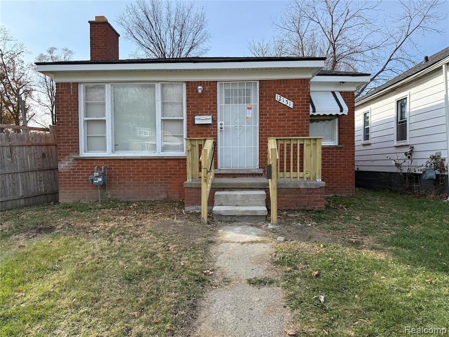


12151 Forrer St Detroit, MI 48227
Plymouth-Detroit NeighborhoodEstimated payment $355/month
Highlights
- Ranch Style House
- No HOA
- Forced Air Heating System
- Cass Technical High School Rated 10
- 1 Car Detached Garage
- 4-minute walk to O'Shea Park
About This Home
Beautiful brick home located in the west side of Detroit. This home features two bedrooms, a bathroom, and much more. Recent upgrades include new roof, new plumbing, and updated plumbing. Schedule your showing today!
Home Details
Home Type
- Single Family
Est. Annual Taxes
- $569
Year Built
- Built in 1957 | Remodeled in 2024
Lot Details
- 3,485 Sq Ft Lot
- Lot Dimensions are 30x120
Parking
- 1 Car Detached Garage
Home Design
- 943 Sq Ft Home
- Ranch Style House
- Brick Exterior Construction
- Block Foundation
Bedrooms and Bathrooms
- 2 Bedrooms
- 1 Full Bathroom
Location
- Ground Level
Utilities
- Forced Air Heating System
- Heating System Uses Natural Gas
- Sewer in Street
Additional Features
- Unfinished Basement
Community Details
- No Home Owners Association
- Capitol Park Sub Subdivision
Listing and Financial Details
- Assessor Parcel Number W22I054614S001
Map
Home Values in the Area
Average Home Value in this Area
Tax History
| Year | Tax Paid | Tax Assessment Tax Assessment Total Assessment is a certain percentage of the fair market value that is determined by local assessors to be the total taxable value of land and additions on the property. | Land | Improvement |
|---|---|---|---|---|
| 2025 | $569 | $4,200 | $0 | $0 |
| 2024 | -- | $0 | $0 | $0 |
| 2023 | $0 | $0 | $0 | $0 |
| 2021 | $0 | $0 | $0 | $0 |
| 2020 | $973 | $0 | $0 | $0 |
| 2019 | $973 | $0 | $0 | $0 |
| 2018 | $0 | $0 | $0 | $0 |
| 2017 | $1,240 | $0 | $0 | $0 |
| 2016 | $240 | $12,400 | $0 | $0 |
| 2015 | $1,240 | $12,400 | $0 | $0 |
| 2013 | $1,292 | $17,363 | $0 | $0 |
| 2010 | -- | $24,878 | $704 | $24,174 |
Property History
| Date | Event | Price | List to Sale | Price per Sq Ft |
|---|---|---|---|---|
| 11/19/2025 11/19/25 | For Sale | $60,000 | -- | $64 / Sq Ft |
Purchase History
| Date | Type | Sale Price | Title Company |
|---|---|---|---|
| Quit Claim Deed | $11,000 | None Listed On Document | |
| Quit Claim Deed | $1,000 | None Available | |
| Deed | -- | Servicelink | |
| Quit Claim Deed | -- | None Available | |
| Sheriffs Deed | $19,727 | None Available | |
| Warranty Deed | $31,400 | -- |
Source: Realcomp
MLS Number: 20251055197
APN: 22-054614-001
Disclaimer: Certain information contained herein is derived from information provided by parties other than Homes.com. All information provided is deemed reliable, but is not guaranteed to be accurate and should be independently verified.
![]() IDX provided courtesy of Realcomp II Ltd. via Ten-X and MLS
IDX provided courtesy of Realcomp II Ltd. via Ten-X and MLS
Copyright 2026 Realcomp II Ltd. Shareholders
IDX information is provided exclusively for consumers' personal, noncommercial use and may not be used for any purpose other than to identify prospective properties consumers may be interested in purchasing. The accuracy of all information, regardless of source, is not guaranteed or warranted. All information should be independently verified.
Listing Information presented by local MLS brokerage: Ten-X, local REALTOR®- Arlene Richardson - (888)-952-6393
- 12235 Rutherford St
- 12057 Forrer St
- 12044 Forrer St
- 12058 Montrose St
- 11717 Montrose St
- 11737 Winthrop St
- 11736 Winthrop St
- 12055 Prest St
- 12017 Asbury Park
- 12244 Woodmont Ave
- 12615 Mettetal St
- 11412 Montrose St
- 12674 Mettetal St
- 11391 Saint Marys St
- 12690 Asbury Park
- 12123 Grandmont Ave
- 11643 Sussex St
- 11684 Sussex St
- 11739 Grandmont Ave
- 11644 Sussex St
- 12044 Forrer St
- 11641 Mansfield St Unit 2
- 12123 Asbury Park
- 11359 Winthrop St
- 12651 Coyle St
- 12690 Coyle St
- 11400 Abington Ave
- 12635 Memorial St
- 15601 Schoolcraft Rd Unit 3
- 15601 Schoolcraft Rd Unit 6
- 15601 Schoolcraft Rd Unit 5
- 15601 Schoolcraft Rd Unit 2
- 15601 Schoolcraft Rd Unit 1
- 13209 Terry St
- 11651 Hubbell St
- 9546 Sussex St
- 9991 Strathmoor St
- 9222 Forrer St
- 9208 Mansfield St
- 9336 Sussex St

Ask me questions while you tour the home.