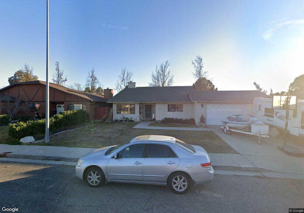
1218 Katherine Dr Paso Robles, CA 93446
Estimated Value: $662,478 - $731,000
3
Beds
2
Baths
1,600
Sq Ft
$434/Sq Ft
Est. Value
About This Home
This home is located at 1218 Katherine Dr, Paso Robles, CA 93446 and is currently estimated at $694,370, approximately $433 per square foot. 1218 Katherine Dr is a home located in San Luis Obispo County with nearby schools including Winifred Pifer Elementary School, Daniel Lewis Middle School, and Paso Robles High School.
Ownership History
Date
Name
Owned For
Owner Type
Purchase Details
Closed on
Apr 5, 2002
Sold by
Roberts William and Roberts Teresa
Bought by
Henson Brian and Henson Lisa
Current Estimated Value
Home Financials for this Owner
Home Financials are based on the most recent Mortgage that was taken out on this home.
Original Mortgage
$194,400
Interest Rate
6.89%
Purchase Details
Closed on
Sep 22, 1993
Sold by
Virgin Edwin F and Virgin Melinda T
Bought by
Roberts William and Roberts Teresa
Home Financials for this Owner
Home Financials are based on the most recent Mortgage that was taken out on this home.
Original Mortgage
$135,702
Interest Rate
7.38%
Mortgage Type
FHA
Create a Home Valuation Report for This Property
The Home Valuation Report is an in-depth analysis detailing your home's value as well as a comparison with similar homes in the area
Purchase History
| Date | Buyer | Sale Price | Title Company |
|---|---|---|---|
| Henson Brian | $243,000 | First American Title Co | |
| Roberts William | $138,000 | Cuesta Title Guaranty Compan |
Source: Public Records
Mortgage History
| Date | Status | Borrower | Loan Amount |
|---|---|---|---|
| Previous Owner | Henson Brian | $194,400 | |
| Previous Owner | Roberts William | $135,702 | |
| Closed | Henson Brian | $48,600 |
Source: Public Records
Tax History
| Year | Tax Paid | Tax Assessment Tax Assessment Total Assessment is a certain percentage of the fair market value that is determined by local assessors to be the total taxable value of land and additions on the property. | Land | Improvement |
|---|---|---|---|---|
| 2025 | $3,835 | $358,964 | $147,720 | $211,244 |
| 2024 | $3,771 | $351,926 | $144,824 | $207,102 |
| 2023 | $3,771 | $345,027 | $141,985 | $203,042 |
| 2022 | $3,713 | $338,262 | $139,201 | $199,061 |
| 2021 | $3,648 | $331,630 | $136,472 | $195,158 |
| 2020 | $3,598 | $328,230 | $135,073 | $193,157 |
| 2019 | $3,545 | $321,795 | $132,425 | $189,370 |
| 2018 | $3,495 | $315,486 | $129,829 | $185,657 |
| 2017 | $3,285 | $309,301 | $127,284 | $182,017 |
| 2016 | $3,219 | $303,238 | $124,789 | $178,449 |
| 2015 | $3,206 | $298,684 | $122,915 | $175,769 |
| 2014 | $3,093 | $292,834 | $120,508 | $172,326 |
Source: Public Records
Map
Nearby Homes
- 1107 Patricia Ln
- 1103 Patricia Ln
- 1036 Samantha Dr
- 4 Dove Ct
- 230 Partridge Ave
- 334 Partridge Ave
- 333 Quail Summit
- 340 Bobwhite Dr
- 940 Austin Ct
- 301 Oak Meadow Ln
- 343 Nightingale Ave
- 250 Santa Bella
- 1006 Eagle Ct
- 268 Camino Lobo
- 912 Wade Dr
- 915 Moran Ct
- 128 Flag Way Unit A
- 358 Via Ramona
- 843 Hacienda Cir
- 2097 Fallbrook Ct
- 1222 Katherine Dr
- 1216 Katherine Dr
- 1226 Katherine Ct
- 1210 Katherine Dr
- 127 Ginger Ln
- 126 Ginger Ln
- 1240 Niblick Rd
- 1230 Niblick Rd
- 1228 Katherine Ct
- 1206 Katherine Dr
- 1250 Niblick Rd
- 128 Rosemary Dr
- 1220 Niblick Rd
- 186 Ginger Ln
- 1235 Katherine Ct
- 1260 Niblick Rd
- 138 Rosemary Dr
- 137 Ginger Ln
- 137 Ginger Ln
- 1230 Katherine Ct
Your Personal Tour Guide
Ask me questions while you tour the home.