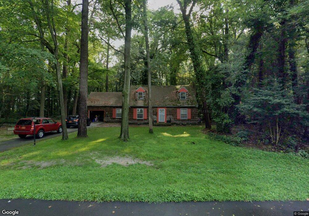
1219 Atlanta Cir Seaford, DE 19973
Estimated Value: $191,000 - $330,000
3
Beds
--
Bath
963
Sq Ft
$250/Sq Ft
Est. Value
About This Home
This home is located at 1219 Atlanta Cir, Seaford, DE 19973 and is currently estimated at $240,667, approximately $249 per square foot. 1219 Atlanta Cir is a home located in Sussex County with nearby schools including Seaford Central Elementary School, Frederick Douglass Elementary School, and Seaford Middle School.
Ownership History
Date
Name
Owned For
Owner Type
Purchase Details
Closed on
Sep 14, 2018
Sold by
Cr 2018 Llc
Bought by
Gomez-Garcia Antonio E
Current Estimated Value
Purchase Details
Closed on
May 8, 2018
Sold by
Us Bank Na
Bought by
Cr 2018 Llc
Purchase Details
Closed on
May 24, 2017
Sold by
Sheriff Of Sussex County
Bought by
Us Bank Na Association
Purchase Details
Closed on
May 5, 1989
Bought by
Lord Joann E and Lord Joseph B
Create a Home Valuation Report for This Property
The Home Valuation Report is an in-depth analysis detailing your home's value as well as a comparison with similar homes in the area
Home Values in the Area
Average Home Value in this Area
Purchase History
| Date | Buyer | Sale Price | Title Company |
|---|---|---|---|
| Gomez-Garcia Antonio E | $29,900 | -- | |
| Cr 2018 Llc | $199,000 | -- | |
| Cr 2018 Llc | $19,040 | -- | |
| Us Bank Na Association | $70,000 | None Available | |
| Lord Joann E | $29,000 | -- |
Source: Public Records
Tax History Compared to Growth
Tax History
| Year | Tax Paid | Tax Assessment Tax Assessment Total Assessment is a certain percentage of the fair market value that is determined by local assessors to be the total taxable value of land and additions on the property. | Land | Improvement |
|---|---|---|---|---|
| 2025 | $695 | $5,300 | $1,300 | $4,000 |
| 2024 | $265 | $5,300 | $1,300 | $4,000 |
| 2023 | $265 | $5,300 | $1,300 | $4,000 |
| 2022 | $258 | $5,300 | $1,300 | $4,000 |
| 2021 | $259 | $5,300 | $1,300 | $4,000 |
| 2020 | $281 | $5,300 | $1,300 | $4,000 |
| 2019 | $246 | $5,300 | $1,300 | $4,000 |
| 2018 | $240 | $5,300 | $0 | $0 |
| 2017 | $228 | $5,300 | $0 | $0 |
| 2016 | $220 | $5,300 | $0 | $0 |
| 2015 | $219 | $5,300 | $0 | $0 |
| 2014 | $208 | $5,300 | $0 | $0 |
Source: Public Records
Map
Nearby Homes
- 6998 Atlanta Cir
- 1403 Tomlinson Dr
- 6873 Robin Dr
- 1102 Wythe Ln
- 23075 Atlanta Rd
- 413 Plantation Dr
- 312 Plantation Dr
- 1123 Magnolia Dr
- 131 Belle Ayre Dr
- 22502 Atlanta Rd
- 501 Chatham Dr
- 0 Helens Ln
- 23849 Ross Station Rd
- 175 Pond View Ln
- 179 Pond View Ln
- 732A Hurley Park Dr
- 714 W Ivy Dr
- 3 Orchard Rd
- 199 Pond View Ln
- 11 Orchard Rd
- 1219 Atlanta Cir
- 1223 Atlanta Cir
- 6978 Atlanta Cir
- 6968 Atlanta Cir
- 6979 Atlanta Cir
- 6988 Atlanta Cir
- 6958 Atlanta Cir
- 6943 Atlanta Cir
- 6993 Atlanta Cir
- 1227 N Atlanta Cir
- 1227 Atlanta Cir
- 6929 Robin Dr
- 7003 Atlanta Cir
- 1405 Tomlinson Dr
- 7012 Atlanta Cir
- Lot #1 N Atlanta Cir
- 6942 Atlanta Cir
- 6915 Robin Dr
- 6942 Robin Dr
- 1407 Tomlinson Dr