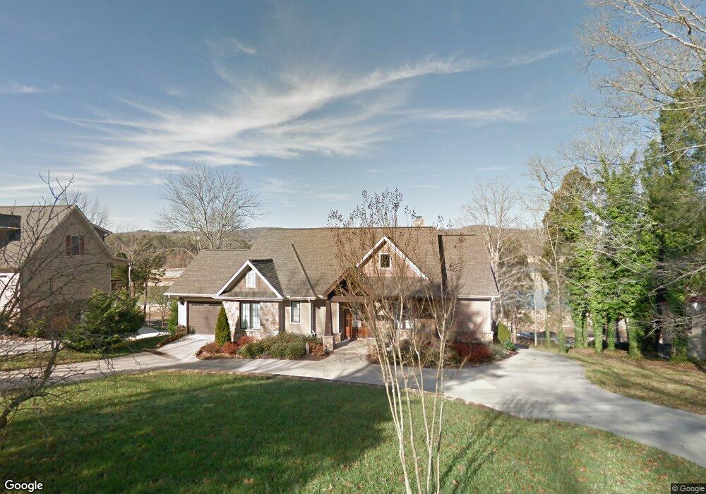
122 Cedar Ln Andersonville, TN 37705
Big Ridge NeighborhoodEstimated Value: $536,000 - $850,000
--
Bed
2
Baths
2,157
Sq Ft
$323/Sq Ft
Est. Value
About This Home
This home is located at 122 Cedar Ln, Andersonville, TN 37705 and is currently estimated at $696,783, approximately $323 per square foot. 122 Cedar Ln is a home located in Anderson County with nearby schools including Big Ridge Elementary School, Union County High School, and H Maynard Middle School.
Ownership History
Date
Name
Owned For
Owner Type
Purchase Details
Closed on
Dec 5, 2019
Sold by
Mowery John D and Mowery Kim A
Bought by
Mowery John D and Mowery Kim A
Current Estimated Value
Purchase Details
Closed on
Aug 21, 2014
Sold by
Mowery John D
Bought by
Mowery Family Trust
Purchase Details
Closed on
May 7, 2002
Sold by
Miller Patricia N
Bought by
Mowery John D
Create a Home Valuation Report for This Property
The Home Valuation Report is an in-depth analysis detailing your home's value as well as a comparison with similar homes in the area
Home Values in the Area
Average Home Value in this Area
Purchase History
| Date | Buyer | Sale Price | Title Company |
|---|---|---|---|
| Mowery John D | -- | None Available | |
| Mowery John D | -- | None Available | |
| Mowery Family Trust | -- | -- | |
| Mowery John D | $159,900 | -- |
Source: Public Records
Tax History Compared to Growth
Tax History
| Year | Tax Paid | Tax Assessment Tax Assessment Total Assessment is a certain percentage of the fair market value that is determined by local assessors to be the total taxable value of land and additions on the property. | Land | Improvement |
|---|---|---|---|---|
| 2024 | $2,387 | $90,800 | $23,225 | $67,575 |
| 2023 | $2,387 | $90,800 | $0 | $0 |
| 2022 | $2,387 | $90,800 | $23,225 | $67,575 |
| 2021 | $2,387 | $90,800 | $23,225 | $67,575 |
| 2020 | $2,320 | $90,800 | $23,225 | $67,575 |
| 2019 | $2,403 | $83,150 | $25,000 | $58,150 |
| 2018 | $2,320 | $83,150 | $25,000 | $58,150 |
| 2017 | $2,320 | $83,150 | $25,000 | $58,150 |
| 2016 | $2,320 | $83,150 | $25,000 | $58,150 |
| 2015 | -- | $83,150 | $25,000 | $58,150 |
| 2014 | -- | $83,150 | $25,000 | $58,150 |
| 2013 | -- | $84,300 | $0 | $0 |
Source: Public Records
Map
Nearby Homes
- 3239 Tennessee 61
- 4985 Andersonville Hwy
- 424 Waterside Cir
- 211 Club House Dr
- 764 Mount Olive Rd
- 0 Mcafee Rd
- 328 Ridge Circle Rd
- 111 Stone Ridge Dr
- 0 Tract 2 Mill Creek Rd
- 107 Sportsman Ln
- Tract 1 Mill Creek Rd
- 328 Dark Hollow Rd N
- 105 Top Sail Ct
- 0 Ridge Circle Rd Unit 1280025
- 0 Ridge Circle Rd Unit 1280024
- 612 Pinnacle Point
- 0 Harbour Club Place Unit 1307207
- 360 Sequoyah Rd
- 0 Park Ln Unit 1307016
- 0 Duncan Ln Unit 1297104