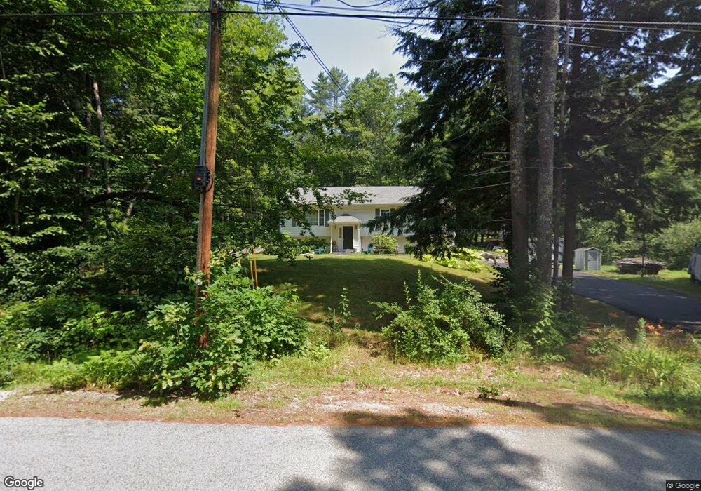
122 Hanson Dr Moultonborough, NH 03254
Estimated Value: $448,000 - $671,000
3
Beds
2
Baths
1,816
Sq Ft
$299/Sq Ft
Est. Value
About This Home
This home is located at 122 Hanson Dr, Moultonborough, NH 03254 and is currently estimated at $542,467, approximately $298 per square foot. 122 Hanson Dr is a home located in Carroll County with nearby schools including Moultonborough Central School, Moultonborough Academy High School, and Immaculate Conception Apostolic School.
Ownership History
Date
Name
Owned For
Owner Type
Purchase Details
Closed on
Apr 18, 2023
Sold by
Baxter David A and Baxter Catherine R
Bought by
Baxter
Current Estimated Value
Purchase Details
Closed on
Aug 24, 2010
Sold by
Knapik Theodore A and Knapik Suzanne E
Bought by
Baxter David A and Baxter Catherine R
Home Financials for this Owner
Home Financials are based on the most recent Mortgage that was taken out on this home.
Original Mortgage
$190,000
Interest Rate
4.63%
Mortgage Type
Purchase Money Mortgage
Create a Home Valuation Report for This Property
The Home Valuation Report is an in-depth analysis detailing your home's value as well as a comparison with similar homes in the area
Home Values in the Area
Average Home Value in this Area
Purchase History
| Date | Buyer | Sale Price | Title Company |
|---|---|---|---|
| Baxter | -- | None Available | |
| Baxter David A | $245,000 | -- |
Source: Public Records
Mortgage History
| Date | Status | Borrower | Loan Amount |
|---|---|---|---|
| Previous Owner | Baxter David A | $190,000 |
Source: Public Records
Tax History Compared to Growth
Tax History
| Year | Tax Paid | Tax Assessment Tax Assessment Total Assessment is a certain percentage of the fair market value that is determined by local assessors to be the total taxable value of land and additions on the property. | Land | Improvement |
|---|---|---|---|---|
| 2024 | $1,970 | $348,600 | $112,300 | $236,300 |
| 2023 | $1,793 | $314,500 | $85,500 | $229,000 |
| 2022 | $1,372 | $287,000 | $77,100 | $209,900 |
| 2021 | $1,709 | $244,800 | $63,100 | $181,700 |
| 2020 | $1,674 | $234,800 | $63,100 | $171,700 |
| 2019 | $1,735 | $242,700 | $63,200 | $179,500 |
| 2018 | $1,812 | $234,700 | $58,600 | $176,100 |
| 2017 | $1,753 | $213,200 | $58,600 | $154,600 |
| 2016 | $1,760 | $201,400 | $58,600 | $142,800 |
| 2015 | $1,798 | $199,600 | $58,600 | $141,000 |
| 2014 | $1,708 | $192,800 | $58,600 | $134,200 |
| 2013 | $1,688 | $194,200 | $58,600 | $135,600 |
Source: Public Records
Map
Nearby Homes
- 203 Krainewood Dr
- 33 Blackadar Ln
- 320 Redding Ln
- 4 Schneider Rd
- 122 Toltec Point Rd
- 22 Tiger Trail
- 30 Leopards Leap
- 38 Lake Shore Dr Unit 12
- 38 Lake Shore Dr Unit 10
- 29 Kona Farm Rd
- 525 Whittier Hwy
- 24 Dew Point Ln
- 00 Whittier Hwy Unit 8
- 2 Little Badger Island
- 100 Marvin Rd
- 52 Chase Cir
- 1 Little Beaver Island
- 244 Wentworth Shores Rd
- 647 Whittier Hwy
- 28 Moose Walk
- 119 Hanson Dr
- 125 Hanson Dr
- 115 Hanson Dr
- 83 Krainewood Dr
- 8 Driftwood Dr
- 7 Driftwood Dr
- 109 Hanson Dr
- 129 Hanson Dr
- 0 Krainewood Dr Unit 11
- Lot 77 Krainewood Dr
- 145 Hanson Dr
- 101 Hanson Dr
- 108 Butternut Ln
- 3 Homestead Ln
- 15 Homestead Ln
- 9 Homestead Ln
- 14 Driftwood Dr
- 166-01 Driftwood Dr
- 9 Homestead Ln
- 93 Hanson Dr