Estimated Value: $6,486,000 - $9,068,000
5
Beds
5
Baths
4,311
Sq Ft
$1,821/Sq Ft
Est. Value
About This Home
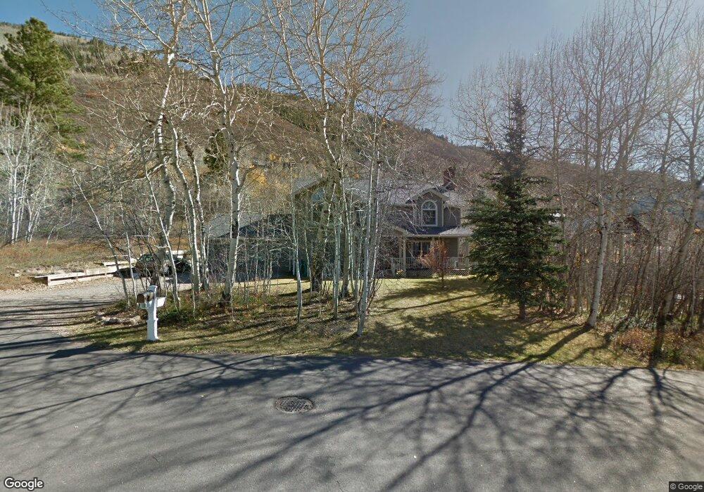
This home is located at 122 Northway Dr, Aspen, CO 81611 and is currently estimated at $7,850,399, approximately $1,821 per square foot. 122 Northway Dr is a home located in Pitkin County with nearby schools including Aspen Elementary School, Aspen Middle School, and Aspen High School.
Ownership History
Date
Name
Owned For
Owner Type
Purchase Details
Closed on
Jun 30, 1987
Bought by
Fisher John E and Fisher Pamela D
Current Estimated Value
Create a Home Valuation Report for This Property
The Home Valuation Report is an in-depth analysis detailing your home's value as well as a comparison with similar homes in the area
Home Values in the Area
Average Home Value in this Area
Purchase History
| Date | Buyer | Sale Price | Title Company |
|---|---|---|---|
| Fisher John E | $150,000 | -- |
Source: Public Records
Tax History Compared to Growth
Tax History
| Year | Tax Paid | Tax Assessment Tax Assessment Total Assessment is a certain percentage of the fair market value that is determined by local assessors to be the total taxable value of land and additions on the property. | Land | Improvement |
|---|---|---|---|---|
| 2024 | $10,540 | $324,610 | $284,860 | $39,750 |
| 2023 | $10,540 | $330,480 | $290,900 | $39,580 |
| 2022 | $10,832 | $292,550 | $215,450 | $77,100 |
| 2021 | $10,785 | $300,960 | $221,650 | $79,310 |
| 2020 | $9,293 | $257,400 | $193,050 | $64,350 |
| 2019 | $9,293 | $257,400 | $193,050 | $64,350 |
| 2018 | $9,426 | $269,810 | $194,400 | $75,410 |
| 2017 | $8,322 | $258,470 | $187,200 | $71,270 |
| 2016 | $7,497 | $228,130 | $175,120 | $53,010 |
| 2015 | $7,401 | $228,130 | $175,120 | $53,010 |
| 2014 | $7,505 | $221,040 | $175,120 | $45,920 |
Source: Public Records
Map
Nearby Homes
- 552 Mountain Laurel Dr
- 602 Mountain Laurel Dr
- 184 Mountain Laurel Dr
- 71 & 73 Smuggler Grove Rd
- 161 Stillwater Ln
- 100 Park Ave
- 1212 E Hopkins Ave
- 326 Midland Ave Unit 306
- 326 Midland Ave Unit 302
- 322 Park Ave Unit 2
- 1271 S Ute Ave
- 1034 E Cooper Ave Unit 19A
- 1024 E Hopkins Ave Unit 16
- 415 Park Cir Unit 5
- 425 Park Cir Unit A2
- 1006 E Cooper Ave
- 515 Park Cir
- 939 E Cooper Ave Unit B
- 10 Ute Place
- 979 Queen St
- 104 Northway Dr
- 473 Mountain Laurel Dr
- 130 Northway Dr
- 119 Northway Dr
- 82 Northway Dr
- 136 Northway Dr
- 449 Mountain Laurel Dr Unit 2
- 449 Mountain Laurel Dr Unit 3
- 449 Mountain Laurel Dr Unit 4
- 449 Mountain Laurel Dr Unit 1
- 449 Mountain Laurel Dr
- 99 Northway Dr
- 137 Northway Dr
- 462 Mountain Laurel Dr
- 549 Mountain Laurel Dr
- 60 Northway Dr
- 15 Westview Dr
- 656 McSkimming Rd
- Tbd & 137 Northway Dr Unit Bl 5 Lots 12 & 14; B
- TBD Northway Dr Unit Block 5 Lot 14