Estimated Value: $128,000 - $145,000
1
Bed
1
Bath
954
Sq Ft
$142/Sq Ft
Est. Value
About This Home
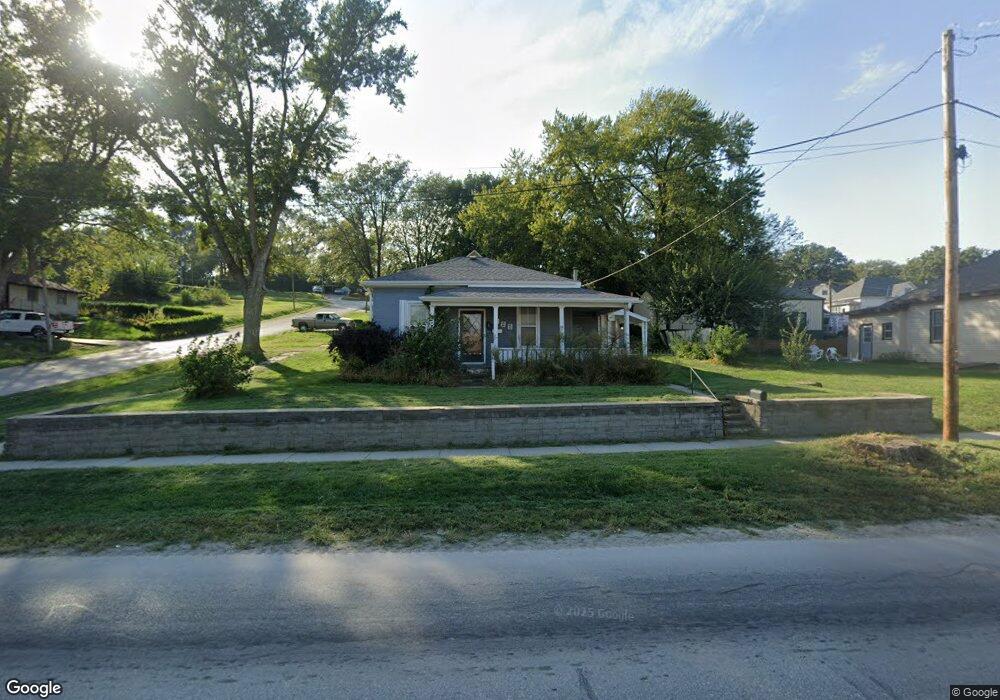
This home is located at 122 S Maple Ave, Logan, IA 51546 and is currently estimated at $135,442, approximately $141 per square foot. 122 S Maple Ave is a home located in Harrison County with nearby schools including Logan-Magnolia Elementary School and Logan-Magnolia Junior/Senior High School.
Ownership History
Date
Name
Owned For
Owner Type
Purchase Details
Closed on
May 10, 2019
Sold by
Kurth Peggy A
Bought by
Kurth Russell G
Current Estimated Value
Purchase Details
Closed on
Jul 12, 2006
Sold by
Birks Delores M
Bought by
Kurth Riley
Home Financials for this Owner
Home Financials are based on the most recent Mortgage that was taken out on this home.
Original Mortgage
$50,800
Interest Rate
6.73%
Mortgage Type
New Conventional
Create a Home Valuation Report for This Property
The Home Valuation Report is an in-depth analysis detailing your home's value as well as a comparison with similar homes in the area
Purchase History
| Date | Buyer | Sale Price | Title Company |
|---|---|---|---|
| Kurth Russell G | -- | -- | |
| Kurth Riley | $94,500 | None Available |
Source: Public Records
Mortgage History
| Date | Status | Borrower | Loan Amount |
|---|---|---|---|
| Previous Owner | Kurth Riley | $50,800 |
Source: Public Records
Tax History
| Year | Tax Paid | Tax Assessment Tax Assessment Total Assessment is a certain percentage of the fair market value that is determined by local assessors to be the total taxable value of land and additions on the property. | Land | Improvement |
|---|---|---|---|---|
| 2025 | $1,478 | $92,810 | $9,980 | $82,830 |
| 2024 | $1,478 | $84,100 | $9,980 | $74,120 |
| 2023 | $1,426 | $84,100 | $9,980 | $74,120 |
| 2022 | $1,194 | $61,265 | $9,975 | $51,290 |
| 2021 | $1,194 | $61,265 | $9,975 | $51,290 |
| 2020 | $1,082 | $57,139 | $9,975 | $47,164 |
| 2019 | $1,350 | $57,139 | $9,975 | $47,164 |
| 2018 | $1,322 | $67,351 | $0 | $0 |
| 2017 | $1,322 | $67,351 | $0 | $0 |
| 2016 | $1,386 | $67,351 | $0 | $0 |
| 2015 | $1,386 | $60,677 | $0 | $0 |
| 2014 | $1,222 | $60,677 | $0 | $0 |
Source: Public Records
Map
Nearby Homes
- 120 W 6th St
- 114 E 10th St
- 217 N 2nd Ave
- 1010 Skyline Dr
- Lot 18 Mulligan Trail
- LOT 27 Mulligan Trail
- LOT 26 Lmvcc Estates
- 2464 Mulligan Trail
- LOT 20 Lmvcc Estates
- LOT 17 Lmvcc Estates
- LOT 15 Mulligan Trail
- 2144 Norton Ave
- 2853 Preston Place
- TBD Preston Place 3 Parcels
- TBD Preston Place 2 Parcels
- LOTS 5 & 6 Fieldcrest Dr
- LOT D Fieldcrest Dr
- LOT 9 & 10 Fieldcrest Dr
- LOT E & K Fieldcrest Dr
- LOT C Fieldcrest Dr
Your Personal Tour Guide
Ask me questions while you tour the home.