
Seller's Agent in 2021
Michele Gutting
Re/Max Savannah
(912) 663-8592
24 in this area
153 Total Sales

Estimated Value: $562,553 - $671,000
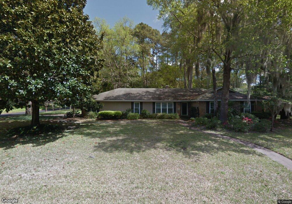
Fabulous Kitchen Remodel Open to the Family Room with Soft Close Dovetail and Pull out Drawers and Frigidaire Gallery Appliances! This Home is what you have been waiting for in Wilmington Park Subdivision on Wilmington Island! Smooth Ceilings, 40 year Architectural Shingle Roof, New Windows, hard to find 4 Bedroom with 3 Full Baths and Large Master on almost 1/2 acre corner lot with Shed, Sprinkler System with Shallow Well for watering and 2 Car Side Entry Garage! It has a Family Room with Hardwood Floors, Fireplace and Built in Bookshelves/Entertainment Center, Freshly Painted Formal Living/Dining Rooms, Ceiling Fans in all Bedrooms, a Heated and Cooled Sunroom and Privacy Fenced Yard with a producing Orange Tree.
Last Agent to Sell the Property
Re/Max Savannah License #171984 Listed on: 05/01/2021
Last Buyer's Agent
Sharon Brookshire
Redfin Corporation License #357054
| Date | Buyer | Sale Price | Title Company |
|---|---|---|---|
| Hubbard Michael B | -- | -- | |
| Hubbard Vicki A | $445,000 | -- | |
| Mcnair Jerry L | -- | -- | |
| Mcnair Jerry L | $247,000 | -- |
| Date | Status | Borrower | Loan Amount |
|---|---|---|---|
| Previous Owner | Hubbard Vicki A | $150,000 |
| Date | Event | Price | List to Sale | Price per Sq Ft |
|---|---|---|---|---|
| 06/03/2021 06/03/21 | Sold | $445,000 | -1.1% | $177 / Sq Ft |
| 05/04/2021 05/04/21 | Pending | -- | -- | -- |
| 05/01/2021 05/01/21 | For Sale | $450,000 | -- | $179 / Sq Ft |
| Year | Tax Paid | Tax Assessment Tax Assessment Total Assessment is a certain percentage of the fair market value that is determined by local assessors to be the total taxable value of land and additions on the property. | Land | Improvement |
|---|---|---|---|---|
| 2025 | $3,871 | $187,720 | $27,720 | $160,000 |
| 2024 | $3,871 | $187,240 | $27,720 | $159,520 |
| 2023 | $3,042 | $165,640 | $27,720 | $137,920 |
| 2022 | $3,321 | $152,480 | $27,720 | $124,760 |
| 2021 | $3,404 | $107,800 | $27,720 | $80,080 |
| 2020 | $3,407 | $107,680 | $27,720 | $79,960 |
| 2019 | $3,528 | $107,680 | $27,720 | $79,960 |
| 2018 | $2,951 | $106,360 | $27,720 | $78,640 |
| 2017 | $2,907 | $96,800 | $27,720 | $69,080 |
| 2016 | $2,985 | $96,360 | $27,720 | $68,640 |
| 2015 | $3,035 | $99,040 | $27,720 | $71,320 |
| 2014 | $4,495 | $102,880 | $0 | $0 |
Seller's Agent in 2021
Michele Gutting
Re/Max Savannah
(912) 663-8592
24 in this area
153 Total Sales
Seller Co-Listing Agent in 2021
Amy Gutting
Re/Max Savannah
22 in this area
146 Total Sales
S
Buyer's Agent in 2021
Sharon Brookshire
Redfin Corporation
Source: Hive MLS
MLS Number: SA247748
APN: 1007303023
Disclaimer: Certain information contained herein is derived from information provided by parties other than Homes.com. All information provided is deemed reliable, but is not guaranteed to be accurate and should be independently verified.
![]() IDX information is provided exclusively for personal, non-commercial use, and may not be used for any purpose other than to identify prospective properties consumers may be interested in purchasing.
IDX information is provided exclusively for personal, non-commercial use, and may not be used for any purpose other than to identify prospective properties consumers may be interested in purchasing.
Information is deemed reliable but not guaranteed.
Ask me questions while you tour the home.