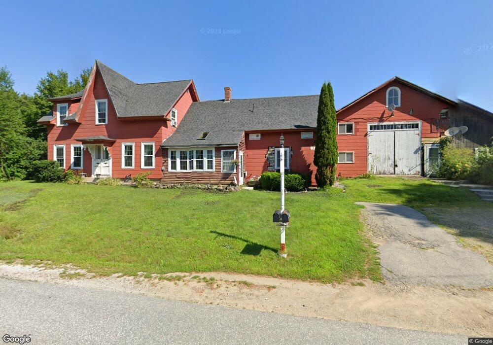
1220 Black Brook Rd Dunbarton, NH 03046
Estimated Value: $167,000 - $489,421
--
Bed
2
Baths
2,260
Sq Ft
$147/Sq Ft
Est. Value
About This Home
This home is located at 1220 Black Brook Rd, Dunbarton, NH 03046 and is currently estimated at $331,855, approximately $146 per square foot. 1220 Black Brook Rd is a home located in Merrimack County with nearby schools including Dunbarton Elementary School, Bow Memorial School, and Bow High School.
Ownership History
Date
Name
Owned For
Owner Type
Purchase Details
Closed on
Feb 11, 2025
Sold by
Greenwood Scott A and Greenwood Heidi A
Bought by
Greenwood Ft and Greenwood
Current Estimated Value
Purchase Details
Closed on
Feb 22, 2011
Sold by
Fnma
Bought by
Greenwood Scott A and Greenwood Heidi A
Purchase Details
Closed on
Jun 4, 2010
Sold by
Lamper Jennifer and Fnma
Bought by
Federal National Mortgage Association
Create a Home Valuation Report for This Property
The Home Valuation Report is an in-depth analysis detailing your home's value as well as a comparison with similar homes in the area
Home Values in the Area
Average Home Value in this Area
Purchase History
| Date | Buyer | Sale Price | Title Company |
|---|---|---|---|
| Greenwood Ft | -- | None Available | |
| Greenwood Ft | -- | None Available | |
| Greenwood Scott A | $52,500 | -- | |
| Greenwood Scott A | $52,500 | -- | |
| Federal National Mortgage Association | $204,700 | -- | |
| Federal National Mortgage Association | $204,700 | -- |
Source: Public Records
Tax History Compared to Growth
Tax History
| Year | Tax Paid | Tax Assessment Tax Assessment Total Assessment is a certain percentage of the fair market value that is determined by local assessors to be the total taxable value of land and additions on the property. | Land | Improvement |
|---|---|---|---|---|
| 2024 | $6,643 | $251,815 | $71,815 | $180,000 |
| 2023 | $6,439 | $251,815 | $71,815 | $180,000 |
| 2022 | $5,787 | $251,815 | $71,815 | $180,000 |
| 2021 | $5,895 | $251,815 | $71,815 | $180,000 |
| 2020 | $5,613 | $251,940 | $71,940 | $180,000 |
| 2018 | $5,061 | $224,631 | $57,031 | $167,600 |
| 2017 | $5,756 | $224,758 | $57,158 | $167,600 |
| 2016 | $5,395 | $224,971 | $57,371 | $167,600 |
| 2015 | $5,307 | $224,985 | $57,385 | $167,600 |
| 2014 | $4,421 | $209,143 | $57,443 | $151,700 |
| 2013 | $4,398 | $209,337 | $57,637 | $151,700 |
Source: Public Records
Map
Nearby Homes
- 602 Black Brook Rd
- 0 Fairway Dr Unit 11
- 22 Fairway Dr
- 45 Range Rd
- 78 Rangeway Rd
- 3 Stephanie Rd
- 22 Winter Hill Rd
- 88 Saunders Rd
- 10 Serenitas Ln
- 22 Peppermint St
- 227 Twist Hill Rd
- 137 Elm St
- 2 Larch St Unit 1
- 99 Elm St
- 12 Maplewood Ave
- 500 E Dunbarton Rd
- 15 Robert Rogers Rd
- 39 S Mast St
- 152 S Mast St
- 328 E Dunbarton Rd
- 1221 Black Brook Rd
- 1209 Black Brook Rd
- 1210 Black Brook Rd
- 526 Tibbetts Hill Rd
- 125 Long Pond Rd
- 10 Little Ln
- 11 Little Ln
- 533 Tibbetts Hill Rd
- 520 Tibbetts Hill Rd
- 698 Black Brook Rd
- 120 Long Pond Rd
- 19 Little Ln
- 118 Long Pond Rd
- 502 Tibbetts Hill Rd
- 18 Little Ln
- 501 Tibbetts Hill Rd
- 1185 Black Brook Rd
- 679 Black Brook Rd
- 676 Black Brook Rd
- 115 Long Pond Rd