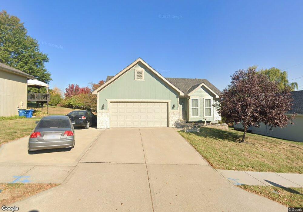
1220 Mockingbird Ln Liberty, MO 64068
Estimated Value: $299,000 - $322,000
3
Beds
3
Baths
1,020
Sq Ft
$306/Sq Ft
Est. Value
About This Home
This home is located at 1220 Mockingbird Ln, Liberty, MO 64068 and is currently estimated at $312,620, approximately $306 per square foot. 1220 Mockingbird Ln is a home located in Clay County with nearby schools including Lillian Schumacher Elementary School, Liberty Middle School, and Liberty High School.
Ownership History
Date
Name
Owned For
Owner Type
Purchase Details
Closed on
Jun 14, 2010
Sold by
Gacek John E and Gacek Darla J
Bought by
Crooks Michael and Crooks Mary
Current Estimated Value
Home Financials for this Owner
Home Financials are based on the most recent Mortgage that was taken out on this home.
Original Mortgage
$100,000
Outstanding Balance
$66,691
Interest Rate
4.87%
Mortgage Type
New Conventional
Estimated Equity
$245,929
Purchase Details
Closed on
Mar 27, 2003
Sold by
S & P Properties Inc
Bought by
Gacek John E and Gacek Darla J
Home Financials for this Owner
Home Financials are based on the most recent Mortgage that was taken out on this home.
Original Mortgage
$154,500
Interest Rate
5.83%
Mortgage Type
VA
Purchase Details
Closed on
Mar 13, 2003
Sold by
Eightreen Investments Inc
Bought by
S & P Properties Inc
Home Financials for this Owner
Home Financials are based on the most recent Mortgage that was taken out on this home.
Original Mortgage
$154,500
Interest Rate
5.83%
Mortgage Type
VA
Purchase Details
Closed on
Feb 14, 2003
Sold by
S & P Properties Inc
Bought by
Eighteen Investments Inc
Home Financials for this Owner
Home Financials are based on the most recent Mortgage that was taken out on this home.
Original Mortgage
$154,500
Interest Rate
5.83%
Mortgage Type
VA
Purchase Details
Closed on
Oct 29, 2002
Sold by
Fors Kathleen R
Bought by
S & P Properties Inc
Purchase Details
Closed on
Nov 7, 2000
Sold by
Frazier Robert F
Bought by
Fors Kathleen R
Home Financials for this Owner
Home Financials are based on the most recent Mortgage that was taken out on this home.
Original Mortgage
$115,200
Interest Rate
10.05%
Purchase Details
Closed on
Oct 20, 1999
Sold by
Sehrer Robert P
Bought by
Frazier Robert F and Frazier Gene E
Home Financials for this Owner
Home Financials are based on the most recent Mortgage that was taken out on this home.
Original Mortgage
$117,000
Interest Rate
7.9%
Create a Home Valuation Report for This Property
The Home Valuation Report is an in-depth analysis detailing your home's value as well as a comparison with similar homes in the area
Purchase History
| Date | Buyer | Sale Price | Title Company |
|---|---|---|---|
| Crooks Michael | -- | Missouri Secured Title Liber | |
| Gacek John E | -- | -- | |
| S & P Properties Inc | -- | -- | |
| Eighteen Investments Inc | -- | Metro One Title | |
| S & P Properties Inc | $114,947 | Stewart Title | |
| Fors Kathleen R | -- | Stewart Title | |
| Frazier Robert F | -- | Stewart Title |
Source: Public Records
Mortgage History
| Date | Status | Borrower | Loan Amount |
|---|---|---|---|
| Open | Crooks Michael | $100,000 | |
| Previous Owner | Gacek John E | $154,500 | |
| Previous Owner | Eighteen Investments Inc | $116,346 | |
| Previous Owner | Fors Kathleen R | $115,200 | |
| Previous Owner | Frazier Robert F | $117,000 | |
| Closed | Fors Kathleen R | $28,800 |
Source: Public Records
Tax History
| Year | Tax Paid | Tax Assessment Tax Assessment Total Assessment is a certain percentage of the fair market value that is determined by local assessors to be the total taxable value of land and additions on the property. | Land | Improvement |
|---|---|---|---|---|
| 2025 | $2,866 | $44,940 | -- | -- |
| 2024 | $2,866 | $37,260 | -- | -- |
| 2023 | $2,914 | $37,260 | $0 | $0 |
| 2022 | $2,776 | $35,040 | $0 | $0 |
| 2021 | $2,754 | $35,036 | $6,650 | $28,386 |
| 2020 | $2,474 | $29,560 | $0 | $0 |
| 2019 | $2,474 | $29,564 | $4,940 | $24,624 |
Source: Public Records
Map
Nearby Homes
- 1846 Mallard Dr
- 1205 Robin Cir
- 939 Goldfinch Ln
- 1877 Chickadee Dr
- 900 Shiloh Ct
- 2218 Liberty Landing Rd
- 1200 Silverleaf Ct
- 2600 Magnolia Ave
- 822 Sherrill Ave
- 1059 Fir Ln
- 1022 Jasmine Dr
- 1026 Jasmine Dr
- 1015 Poplar Ln
- 1007 Poplar Ln
- 1027 Fir Ln
- 988 Poplar Ln
- 1012 Poplar Ln
- 1015 Fir Ln
- 904 Paw Ln
- 709 Red Maple Dr
- 1216 Mockingbird Ln
- 1224 Mockingbird Ln
- 1213 Meadowlark Ct
- 1217 Meadowlark Ct
- 1228 Mockingbird Ln
- 1221 Mockingbird Ln
- 1225 Mockingbird Ln
- 1209 Meadowlark Ct
- 1221 Meadowlark Ct
- 1840 Current St
- 1232 Mockingbird Ln
- 1229 Mockingbird Ln
- 1859 Claywoods Pkwy
- 1205 Meadowlark Ct
- 1843 Current St
- 1224 Meadowlark Ct
- 1868 Claywoods Pkwy
- 1233 Mockingbird Ln
- 1867 Claywoods Pkwy
- 1236 Mockingbird Ln
Your Personal Tour Guide
Ask me questions while you tour the home.