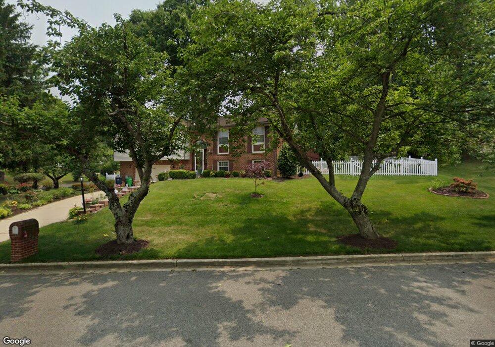
12205 Chesterton Dr Upper Marlboro, MD 20774
Estimated Value: $437,079 - $485,000
--
Bed
3
Baths
1,802
Sq Ft
$253/Sq Ft
Est. Value
About This Home
This home is located at 12205 Chesterton Dr, Upper Marlboro, MD 20774 and is currently estimated at $456,520, approximately $253 per square foot. 12205 Chesterton Dr is a home located in Prince George's County with nearby schools including Perrywood Elementary School, Kettering Middle School, and Largo High School.
Ownership History
Date
Name
Owned For
Owner Type
Purchase Details
Closed on
Jul 25, 2025
Sold by
Parker-Jones Bernice and Parker Bernice
Bought by
Parker-Jones Bernice and Richardson Natalie
Current Estimated Value
Purchase Details
Closed on
Jul 19, 1994
Sold by
Flage Donald W
Bought by
Parker Bernice
Home Financials for this Owner
Home Financials are based on the most recent Mortgage that was taken out on this home.
Original Mortgage
$142,400
Interest Rate
8.51%
Purchase Details
Closed on
Jun 5, 1979
Sold by
Townshend George A
Bought by
Flage Donald W and Flage Margaret S
Create a Home Valuation Report for This Property
The Home Valuation Report is an in-depth analysis detailing your home's value as well as a comparison with similar homes in the area
Home Values in the Area
Average Home Value in this Area
Purchase History
| Date | Buyer | Sale Price | Title Company |
|---|---|---|---|
| Parker-Jones Bernice | -- | None Listed On Document | |
| Parker Bernice | $149,900 | -- | |
| Flage Donald W | $79,000 | -- |
Source: Public Records
Mortgage History
| Date | Status | Borrower | Loan Amount |
|---|---|---|---|
| Previous Owner | Parker Bernice | $142,400 |
Source: Public Records
Tax History Compared to Growth
Tax History
| Year | Tax Paid | Tax Assessment Tax Assessment Total Assessment is a certain percentage of the fair market value that is determined by local assessors to be the total taxable value of land and additions on the property. | Land | Improvement |
|---|---|---|---|---|
| 2025 | $6,930 | $457,700 | $102,700 | $355,000 |
| 2024 | $6,930 | $439,500 | $0 | $0 |
| 2023 | $6,658 | $421,300 | $0 | $0 |
| 2022 | $6,388 | $403,100 | $102,700 | $300,400 |
| 2021 | $5,840 | $366,233 | $0 | $0 |
| 2020 | $5,292 | $329,367 | $0 | $0 |
| 2019 | $4,744 | $292,500 | $101,300 | $191,200 |
| 2018 | $4,477 | $274,500 | $0 | $0 |
| 2017 | $4,209 | $256,500 | $0 | $0 |
| 2016 | -- | $238,500 | $0 | $0 |
| 2015 | $3,507 | $238,500 | $0 | $0 |
| 2014 | $3,507 | $238,500 | $0 | $0 |
Source: Public Records
Map
Nearby Homes
- 12215 Wimbleton St
- 136 Old Enterprise Rd
- 120 Old Enterprise Rd
- 83 Watkins Park Dr
- 12100 Wimbleton St
- 999 Kings Heather Dr
- 12812 Staton Ct
- 111 Essenton Dr
- 1100 Kings Heather Dr
- 100 Essenton Dr
- 203 Dauntly St
- 13006 Brice Ct
- 1116 Kings Tree Dr
- 12203 Kings Arrow St
- 11440 Red Jade Ct Unit 6-3
- 221 Red Jade Dr Unit 9-1
- 13200 Wright Place
- 11320 Kettering Terrace
- 13108 Keverton Dr
- 11518 Joyceton Dr Unit 35-3
- 12220 Wimbleton St
- 12200 Blaketon St
- 12204 Chesterton Dr
- 12202 Blaketon St
- 12223 Wimbleton St
- 12221 Wimbleton St
- 12114 Blaketon St
- 12218 Wimbleton St
- 12219 Wimbleton St
- 12204 Blaketon St
- 12212 Hunterton St
- 12211 Hunterton St
- 12112 Blaketon St
- 12217 Wimbleton St
- 12201 Blaketon St
- 12216 Wimbleton St
- 76 Old Enterprise Rd
- 78 Old Enterprise Rd
- 12210 Hunterton St
- 74 Old Enterprise Rd