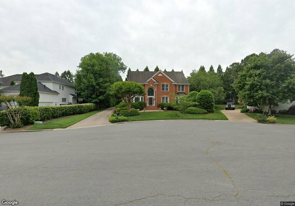
12205 Loxton Way Glen Allen, VA 23059
Estimated Value: $792,667 - $895,000
4
Beds
3
Baths
3,643
Sq Ft
$230/Sq Ft
Est. Value
About This Home
This home is located at 12205 Loxton Way, Glen Allen, VA 23059 and is currently estimated at $836,167, approximately $229 per square foot. 12205 Loxton Way is a home located in Henrico County with nearby schools including Shady Grove Elementary School, Short Pump Middle School, and Deep Run High School.
Ownership History
Date
Name
Owned For
Owner Type
Purchase Details
Closed on
Aug 26, 1999
Bought by
Wendt Peter and Wendt Cynthia M
Current Estimated Value
Home Financials for this Owner
Home Financials are based on the most recent Mortgage that was taken out on this home.
Original Mortgage
$354,800
Outstanding Balance
$102,844
Interest Rate
7.53%
Mortgage Type
New Conventional
Estimated Equity
$733,323
Create a Home Valuation Report for This Property
The Home Valuation Report is an in-depth analysis detailing your home's value as well as a comparison with similar homes in the area
Home Values in the Area
Average Home Value in this Area
Purchase History
| Date | Buyer | Sale Price | Title Company |
|---|---|---|---|
| Wendt Peter | $375,000 | -- |
Source: Public Records
Mortgage History
| Date | Status | Borrower | Loan Amount |
|---|---|---|---|
| Open | Wendt Peter | $354,800 |
Source: Public Records
Tax History Compared to Growth
Tax History
| Year | Tax Paid | Tax Assessment Tax Assessment Total Assessment is a certain percentage of the fair market value that is determined by local assessors to be the total taxable value of land and additions on the property. | Land | Improvement |
|---|---|---|---|---|
| 2025 | $5,979 | $657,600 | $160,000 | $497,600 |
| 2024 | $5,979 | $657,600 | $160,000 | $497,600 |
| 2023 | $5,590 | $657,600 | $160,000 | $497,600 |
| 2022 | $5,042 | $593,200 | $160,000 | $433,200 |
| 2021 | $4,324 | $506,100 | $140,000 | $366,100 |
| 2020 | $4,403 | $506,100 | $140,000 | $366,100 |
| 2019 | $4,271 | $490,900 | $140,000 | $350,900 |
| 2018 | $4,271 | $490,900 | $140,000 | $350,900 |
| 2017 | $4,271 | $490,900 | $140,000 | $350,900 |
| 2016 | $4,271 | $490,900 | $140,000 | $350,900 |
| 2015 | $4,403 | $506,100 | $140,000 | $366,100 |
| 2014 | $4,403 | $506,100 | $140,000 | $366,100 |
Source: Public Records
Map
Nearby Homes
- 12100 Manor Park Dr
- 6233 Kershaw Dr
- 12504 Collinstone Ct
- 5900 Maybrook Dr
- 12012 Layton Dr
- 6009 Chestnut Hill Dr
- 12410 Creek Mill Ct
- 14357 Western Riders Ln
- 11824 Park Forest Way
- 6573 Glenshaw Dr
- 5410 Ridgedale Dr
- 5408 Fuller Dr
- 5400 Fuller Dr
- 5604 Ashton Park Ct
- 10813 Cherry Hill Dr
- 12309 Hardwick Ct
- 10801 Cherry Hill Dr
- 7025 Benhall Cir
- 5525 Barnsley Terrace
- 5557 Holman Dr
- 12201 Loxton Way
- 12209 Loxton Way
- 12204 Denford Way
- 12200 Denford Way
- 12208 Denford Way
- 12208 Loxton Way
- 12204 Loxton Way
- 12200 Loxton Way
- 12113 Loxton Ct
- 12116 Denford Ct
- 12209 Denford Way
- 12173 Morestead Ct
- 12116 Loxton Ct
- 12201 Denford Way
- 12169 Morestead Ct
- 12109 Loxton Ct
- 12205 Denford Way
- 12165 Morestead Ct
- 12112 Denford Ct
- 12161 Morestead Ct