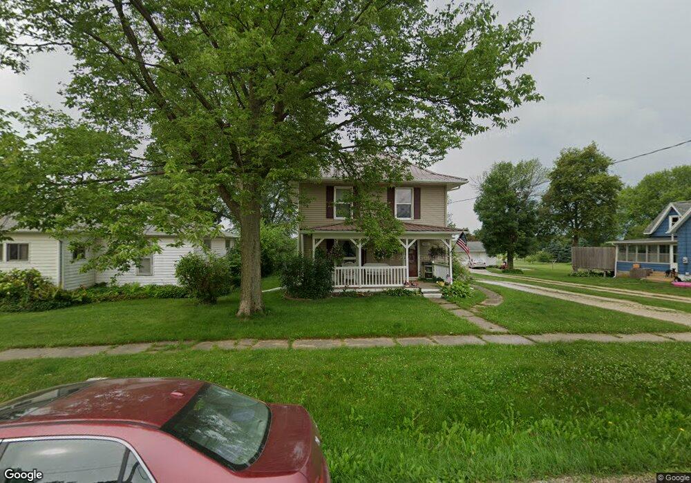
1221 Summit St Center Point, IA 52213
Estimated Value: $190,000 - $223,000
4
Beds
2
Baths
1,824
Sq Ft
$115/Sq Ft
Est. Value
About This Home
This home is located at 1221 Summit St, Center Point, IA 52213 and is currently estimated at $208,864, approximately $114 per square foot. 1221 Summit St is a home located in Linn County with nearby schools including Center Point-Urbana Primary School, Center Point-Urbana Intermediate School, and Center Point-Urbana Middle School.
Ownership History
Date
Name
Owned For
Owner Type
Purchase Details
Closed on
Sep 15, 2025
Sold by
Rhoads Daniel James
Bought by
Rhoads Meredith E
Current Estimated Value
Purchase Details
Closed on
May 19, 2017
Sold by
Skinner Matthew E and Skinner Amanda J
Bought by
Rhoads Meredith E and Rhoads Daniel J
Home Financials for this Owner
Home Financials are based on the most recent Mortgage that was taken out on this home.
Original Mortgage
$156,120
Interest Rate
4.03%
Mortgage Type
FHA
Purchase Details
Closed on
Jun 17, 2010
Sold by
Siech Michael A and Siech Pamella M
Bought by
Skinner Matthew E and Skinner Amanda J
Home Financials for this Owner
Home Financials are based on the most recent Mortgage that was taken out on this home.
Original Mortgage
$104,465
Interest Rate
5.05%
Mortgage Type
New Conventional
Create a Home Valuation Report for This Property
The Home Valuation Report is an in-depth analysis detailing your home's value as well as a comparison with similar homes in the area
Home Values in the Area
Average Home Value in this Area
Purchase History
| Date | Buyer | Sale Price | Title Company |
|---|---|---|---|
| Rhoads Meredith E | -- | None Listed On Document | |
| Rhoads Meredith E | -- | None Available | |
| Skinner Matthew E | $122,500 | None Available |
Source: Public Records
Mortgage History
| Date | Status | Borrower | Loan Amount |
|---|---|---|---|
| Previous Owner | Rhoads Meredith E | $156,120 | |
| Previous Owner | Skinner Matthew E | $104,465 |
Source: Public Records
Tax History Compared to Growth
Tax History
| Year | Tax Paid | Tax Assessment Tax Assessment Total Assessment is a certain percentage of the fair market value that is determined by local assessors to be the total taxable value of land and additions on the property. | Land | Improvement |
|---|---|---|---|---|
| 2025 | $3,372 | $187,200 | $19,700 | $167,500 |
| 2024 | $3,194 | $196,100 | $19,700 | $176,400 |
| 2023 | $3,194 | $196,100 | $19,700 | $176,400 |
| 2022 | $3,186 | $157,200 | $19,700 | $137,500 |
| 2021 | $3,038 | $157,200 | $19,700 | $137,500 |
| 2020 | $3,038 | $142,800 | $19,700 | $123,100 |
| 2019 | $2,780 | $134,600 | $19,700 | $114,900 |
| 2018 | $2,714 | $134,600 | $19,700 | $114,900 |
| 2017 | $2,768 | $133,200 | $19,700 | $113,500 |
| 2016 | $2,855 | $133,200 | $19,700 | $113,500 |
| 2015 | $2,857 | $133,200 | $19,700 | $113,500 |
| 2014 | $2,670 | $132,600 | $19,100 | $113,500 |
| 2013 | $2,636 | $132,600 | $19,100 | $113,500 |
Source: Public Records
Map
Nearby Homes
- 508 Vine St
- 120 Green St
- 132 Green St
- 316 E Washington St
- 1208 Franklin St
- 718 Pointer Cir
- 717 Pointer Cir
- 708 Rogers Ln
- 603 Pointer Cir
- 0 Iowa St
- 1120 Central Ave
- 523 Rogers Ln
- 702 Central Ave
- 920 E Washington St
- 809 Iowa St
- 1109 Grubbs St
- 1010 Northview Dr
- 115 Main St
- 507 Maplewood Dr
- 4505 Urbana Rd Unit West Parcel