Estimated Value: $294,636 - $343,000
3
Beds
2
Baths
1,004
Sq Ft
$322/Sq Ft
Est. Value
About This Home
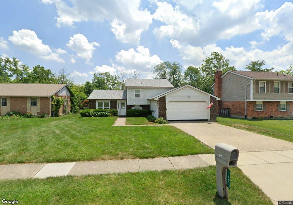
This home is located at 1223 Anthony Ln, Mason, OH 45040 and is currently estimated at $323,409, approximately $322 per square foot. 1223 Anthony Ln is a home located in Warren County with nearby schools including Mason Intermediate Elementary School, Mason Middle School, and William Mason High School.
Ownership History
Date
Name
Owned For
Owner Type
Purchase Details
Closed on
Oct 24, 2023
Sold by
Nelson Paul O and Nelson Nadine C
Bought by
Nelson Paul O and Nelson Paul O
Current Estimated Value
Purchase Details
Closed on
Aug 29, 1995
Sold by
Engelbrink Gary H
Bought by
Nelson Paul O and Nelson Nadine C
Purchase Details
Closed on
Sep 27, 1989
Sold by
Gidley Stephen A and Gidley Denise
Bought by
Engelbrink and Engelbrink Gary H
Purchase Details
Closed on
Dec 9, 1985
Sold by
Center & Gregory Thomas
Bought by
Gidley Gidley and Gidley Stephen A
Create a Home Valuation Report for This Property
The Home Valuation Report is an in-depth analysis detailing your home's value as well as a comparison with similar homes in the area
Home Values in the Area
Average Home Value in this Area
Purchase History
| Date | Buyer | Sale Price | Title Company |
|---|---|---|---|
| Nelson Paul O | -- | None Listed On Document | |
| Nelson Paul O | $96,000 | -- | |
| Engelbrink | $88,900 | -- | |
| Gidley Gidley | $67,000 | -- |
Source: Public Records
Mortgage History
| Date | Status | Borrower | Loan Amount |
|---|---|---|---|
| Closed | Nelson Paul O | -- |
Source: Public Records
Tax History Compared to Growth
Tax History
| Year | Tax Paid | Tax Assessment Tax Assessment Total Assessment is a certain percentage of the fair market value that is determined by local assessors to be the total taxable value of land and additions on the property. | Land | Improvement |
|---|---|---|---|---|
| 2024 | $2,364 | $77,860 | $24,500 | $53,360 |
| 2023 | $2,368 | $58,054 | $10,762 | $47,292 |
| 2022 | $2,338 | $58,055 | $10,763 | $47,292 |
| 2021 | $2,215 | $58,055 | $10,763 | $47,292 |
| 2020 | $2,473 | $47,198 | $8,750 | $38,448 |
| 2019 | $2,273 | $47,198 | $8,750 | $38,448 |
| 2018 | $2,281 | $47,198 | $8,750 | $38,448 |
| 2017 | $2,105 | $40,670 | $8,274 | $32,396 |
| 2016 | $2,169 | $40,670 | $8,274 | $32,396 |
| 2015 | $2,173 | $40,670 | $8,274 | $32,396 |
| 2014 | $2,178 | $38,010 | $7,730 | $30,280 |
| 2013 | $2,183 | $43,020 | $8,750 | $34,270 |
Source: Public Records
Map
Nearby Homes
- 6138 Nicholas Way
- 6387 Coverage Ct
- 6369 Coverage Ct
- 6403 Coverage Ct
- 6357 Coverage Ct
- 6383 Coverage Ct
- 6407 Coverage Ct
- 6375 Coverage Ct
- 6365 Coverage Ct
- 6361 Coverage Ct
- 6379 Coverage Ct
- 6411 Coverage Ct
- 6126 Nicholas Way
- 6146 Nicholas Way
- 6358 Coverage Ct
- 6362 Coverage Ct
- 6356 Amber Ct Unit 91
- 873 Tradewind Dr
- 6070 Fireside Dr Unit 45
- 947 Olympia Dr
- 1227 Anthony Ln
- 1219 Anthony Ln
- 1231 Anthony Ln
- 1215 Anthony Ln
- 1235 Anthony Ln
- 1230 Anthony Ln
- 1226 Anthony Ln
- 1234 Anthony Ln
- 1222 Anthony Ln
- 1238 Anthony Ln
- 1239 Anthony Ln
- 1211 Anthony Ln
- 1240 Anthony Ln
- 1218 Anthony Ln
- 1243 Anthony Ln
- 1244 Anthony Ln
- 916 Tracy Place
- 912 Tracy Place
- 1207 Anthony Ln
- 908 Tracy Place