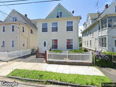
1223 Norman St Unit 1225 Bridgeport, CT 06604
Brooklawn-Saint Vincent NeighborhoodEstimated Value: $321,121 - $564,000
3
Beds
3
Baths
2,322
Sq Ft
$193/Sq Ft
Est. Value
About This Home
This home is located at 1223 Norman St Unit 1225, Bridgeport, CT 06604 and is currently estimated at $447,030, approximately $192 per square foot. 1223 Norman St Unit 1225 is a home located in Fairfield County with nearby schools including Geraldine Johnson School, Bassick High School, and Catholic Academy of Bridgeport-St. Raphael Academy.
Ownership History
Date
Name
Owned For
Owner Type
Purchase Details
Closed on
Oct 28, 2003
Sold by
Kubowicz Kristina
Bought by
Gomez-Coello Magno
Current Estimated Value
Home Financials for this Owner
Home Financials are based on the most recent Mortgage that was taken out on this home.
Original Mortgage
$185,000
Outstanding Balance
$90,022
Interest Rate
6.15%
Estimated Equity
$338,217
Create a Home Valuation Report for This Property
The Home Valuation Report is an in-depth analysis detailing your home's value as well as a comparison with similar homes in the area
Home Values in the Area
Average Home Value in this Area
Purchase History
| Date | Buyer | Sale Price | Title Company |
|---|---|---|---|
| Gomez-Coello Magno | $190,000 | -- | |
| Gomez-Coello Magno | $190,000 | -- |
Source: Public Records
Mortgage History
| Date | Status | Borrower | Loan Amount |
|---|---|---|---|
| Open | Gomez-Coello Magno | $185,000 | |
| Closed | Gomez-Coello Magno | $185,000 |
Source: Public Records
Tax History Compared to Growth
Tax History
| Year | Tax Paid | Tax Assessment Tax Assessment Total Assessment is a certain percentage of the fair market value that is determined by local assessors to be the total taxable value of land and additions on the property. | Land | Improvement |
|---|---|---|---|---|
| 2024 | $7,712 | $177,490 | $67,390 | $110,100 |
| 2023 | $7,712 | $177,490 | $67,390 | $110,100 |
| 2022 | $7,712 | $177,490 | $67,390 | $110,100 |
| 2021 | $7,712 | $177,490 | $67,390 | $110,100 |
| 2020 | $7,167 | $132,750 | $40,850 | $91,900 |
| 2019 | $7,167 | $132,750 | $40,850 | $91,900 |
| 2018 | $7,218 | $132,750 | $40,850 | $91,900 |
| 2017 | $7,218 | $132,750 | $40,850 | $91,900 |
| 2016 | $7,218 | $132,750 | $40,850 | $91,900 |
| 2015 | $6,935 | $164,340 | $43,250 | $121,090 |
| 2014 | $6,935 | $164,340 | $43,250 | $121,090 |
Source: Public Records
Map
Nearby Homes
- 128 Bancroft Ave
- 501 Pequonnock St
- 88 Pierce Ave
- 64-66 Maplewood Ave
- 1057 Briarwood Ave
- 141 Arcadia Ave
- 2370 North Ave Unit 12G
- 2370 North Ave Unit 6A
- 2370 North Ave Unit 10A
- 2370 North Ave Unit 9D
- 2370 North Ave Unit 5A
- 2370 North Ave Unit 9G
- 1391 North Ave Unit 1393
- 599 Laurel Ave
- 191 Oak St
- 1356 Wood Ave
- 265 Olive St
- 127 Jones Ave
- 84 Hillside Ave
- 8 Lynnbrook Rd
- 1223 Norman St Unit 1225
- 1231 Norman St Unit 1235
- 1217 Norman St Unit 1219
- 16 Staples St
- 1209 Norman St Unit 1211
- 1203 Norman St Unit 1205
- 26 Staples St Unit 3
- 26 Staples St
- 135 Eaton St Unit 137
- 114 Merchant St Unit 116
- 36 Staples St
- 155 Eaton St
- 145 Eaton St Unit 147
- 115 Merchant St Unit 117
- 345 Benham Ave Unit C1
- 345 Benham Ave
- 25 Cartright St
- 345 Benham Ave Unit C5
- 44 Staples St
- 102 Merchant St Unit 104