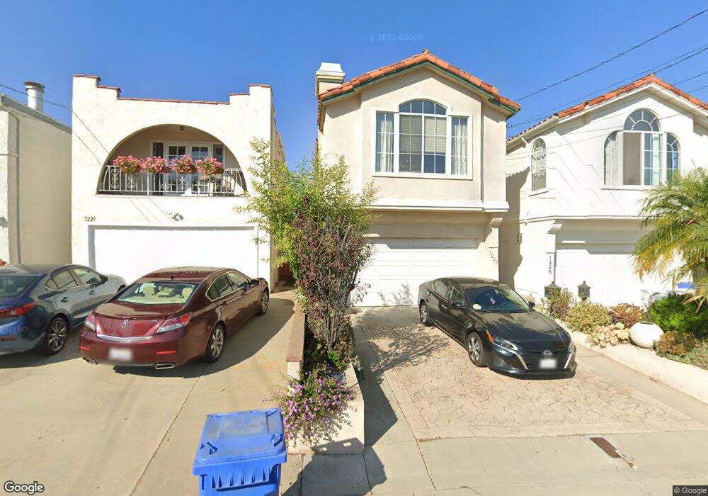
1223 Stanford Ave Redondo Beach, CA 90278
North Redondo Beach NeighborhoodEstimated Value: $1,625,245 - $1,887,000
3
Beds
3
Baths
1,900
Sq Ft
$937/Sq Ft
Est. Value
About This Home
This home is located at 1223 Stanford Ave, Redondo Beach, CA 90278 and is currently estimated at $1,780,561, approximately $937 per square foot. 1223 Stanford Ave is a home located in Los Angeles County with nearby schools including Jefferson Elementary School, Parras (Nick G.) Middle School, and Redondo Union High School.
Ownership History
Date
Name
Owned For
Owner Type
Purchase Details
Closed on
Aug 21, 2012
Sold by
Tiongson Omar V
Bought by
Tiongson Omar and Omar V Tiongson Family Trust
Current Estimated Value
Purchase Details
Closed on
Aug 17, 2012
Sold by
Tiongson Omar V and Tiongson Donna Lisa
Bought by
Tiongson Omar
Purchase Details
Closed on
Mar 23, 2011
Sold by
Tiongson Donna Lisa
Bought by
Tiongson Omar and Tiongson Jose P
Purchase Details
Closed on
Jun 5, 2002
Sold by
Tiongson Omar V and Tiongson Donna Lisa
Bought by
Tiongson Omar
Create a Home Valuation Report for This Property
The Home Valuation Report is an in-depth analysis detailing your home's value as well as a comparison with similar homes in the area
Home Values in the Area
Average Home Value in this Area
Purchase History
| Date | Buyer | Sale Price | Title Company |
|---|---|---|---|
| Tiongson Omar | -- | None Available | |
| Tiongson Omar | -- | None Available | |
| Tiongson Omar | -- | None Available | |
| Tiongson Omar | -- | None Available | |
| Tiongson Omar | -- | None Available | |
| Tiongson Omar | -- | -- |
Source: Public Records
Tax History Compared to Growth
Tax History
| Year | Tax Paid | Tax Assessment Tax Assessment Total Assessment is a certain percentage of the fair market value that is determined by local assessors to be the total taxable value of land and additions on the property. | Land | Improvement |
|---|---|---|---|---|
| 2025 | $8,131 | $672,524 | $202,220 | $470,304 |
| 2024 | $8,131 | $659,338 | $198,255 | $461,083 |
| 2023 | $7,986 | $646,411 | $194,368 | $452,043 |
| 2022 | $7,837 | $633,737 | $190,557 | $443,180 |
| 2021 | $7,621 | $621,312 | $186,821 | $434,491 |
| 2019 | $7,431 | $602,885 | $181,281 | $421,604 |
| 2018 | $7,219 | $591,065 | $177,727 | $413,338 |
| 2016 | $6,977 | $568,116 | $170,827 | $397,289 |
| 2015 | $6,852 | $559,584 | $168,262 | $391,322 |
| 2014 | $6,753 | $548,623 | $164,966 | $383,657 |
Source: Public Records
Map
Nearby Homes
- 1209 Stanford Ave
- 1141 Stanford Ave
- 1108 Stanford Ave
- 1504 Prospect Ave
- 1137 9th St
- 1513 Carver St
- 1306 Carmelita Ave
- 1430 Bonnie Brae St
- 1303 Harkness Ln
- 1502 Ocean Dr
- 1536 Wollacott St
- 867 Aubrey Ct Unit 1
- 1620 Harper Ave
- 1116 7th St
- 1133 7th Place
- 1022 17th St
- 1812 Clark Ln Unit A
- 1814 Pullman Ln
- 924 17th St
- 926 17th St
- 1221 Stanford Ave
- 1225 Stanford Ave
- 1219 Stanford Ave
- 1227 Stanford Ave
- 1217 Stanford Ave
- 1229 Stanford Ave
- 1224 Harper Ave
- 1215 Stanford Ave
- 1218 Harper Ave
- 1233 Stanford Ave
- 1228 Harper Ave
- 1216 Harper Ave
- 1214 Harper Ave
- 1230 Harper Ave
- 1210 Stanford Ave
- 1211 Stanford Ave
- 1212 Stanford Ave
- 1208 Stanford Ave
- 1212 Harper Ave
- 1214 Stanford Ave