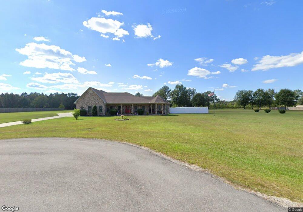
12235 E Pointe Dr Picayune, MS 39466
Estimated Value: $553,000 - $573,000
3
Beds
1
Bath
4,198
Sq Ft
$134/Sq Ft
Est. Value
About This Home
This home is located at 12235 E Pointe Dr, Picayune, MS 39466 and is currently estimated at $563,305, approximately $134 per square foot. 12235 E Pointe Dr is a home with nearby schools including West Hancock Elementary School, Hancock Middle School, and Hancock High School.
Ownership History
Date
Name
Owned For
Owner Type
Purchase Details
Closed on
Jun 6, 2023
Sold by
Lee Justina J
Bought by
Blankenship Brent M and Blankenship Bonnie
Current Estimated Value
Purchase Details
Closed on
Aug 19, 2022
Sold by
Neill Blankenship Larry and Morgan Darlene
Bought by
Blankenship Brent M and Blankenship Bonnie
Purchase Details
Closed on
Mar 18, 2022
Sold by
Salvador Francisco A
Bought by
Blankenship Larry Noll and Blankenship Darlene Morgan
Create a Home Valuation Report for This Property
The Home Valuation Report is an in-depth analysis detailing your home's value as well as a comparison with similar homes in the area
Purchase History
| Date | Buyer | Sale Price | Title Company |
|---|---|---|---|
| Blankenship Brent M | -- | None Listed On Document | |
| Blankenship Brent M | -- | None Listed On Document | |
| Blankenship Brent M | -- | Reso Melissa Nunley | |
| Blankenship Brent M | -- | None Listed On Document | |
| Blankenship Larry Noll | -- | Pilger David B | |
| Blankenship Larry Noll | -- | Pilger David B |
Source: Public Records
Tax History
| Year | Tax Paid | Tax Assessment Tax Assessment Total Assessment is a certain percentage of the fair market value that is determined by local assessors to be the total taxable value of land and additions on the property. | Land | Improvement |
|---|---|---|---|---|
| 2025 | $3,367 | $35,357 | $2,611 | $32,746 |
| 2024 | $3,367 | $35,357 | $2,611 | $32,746 |
| 2023 | $3,367 | $35,357 | $2,611 | $32,746 |
| 2022 | $2,587 | $34,661 | $2,611 | $32,050 |
| 2021 | $2,587 | $34,661 | $2,611 | $32,050 |
| 2020 | $2,339 | $31,177 | $2,611 | $28,566 |
| 2019 | $2,339 | $31,177 | $2,611 | $28,566 |
| 2018 | $2,419 | $31,986 | $2,611 | $29,375 |
| 2017 | $2,350 | $31,287 | $2,611 | $28,676 |
| 2016 | $2,572 | $29,817 | $2,611 | $27,206 |
| 2015 | $2,216 | $27,540 | $2,807 | $24,733 |
| 2014 | $3,496 | $39,079 | $1,980 | $37,099 |
| 2013 | $171 | $1,980 | $1,980 | $0 |
Source: Public Records
Map
Nearby Homes
- 24094 Rester Rd
- 24327 Rester Rd
- 00 N Benville Rd
- 23436 N Benville Rd
- 0 N Benville Rd Unit 4138082
- S Leetown and Highway 43
- 0 S Leetown and Highway 43 Hwy Unit 4067215
- 23280 Leetown Rd
- 12009 Circle G Ranch Rd
- 26230 Longvue Dr
- 26340 Strickland Rd
- 11084 Road 231
- 11080 Road 231
- 521 Old Kiln Rd
- 24100 Autumn Place
- 27019 Leetown Rd
- 24220 Autumn Ln
- 14014 Lott McCarty Rd
- 2670 Long Leaf Dr
- 3643 Long Leaf Dr
- 12241 E East Pointe Dr
- 12241 E Pointe Dr
- 12239 E Pointe Dr
- 19 E Pointe Dr
- 13 E Pointe Dr
- 11 E Pointe Dr
- 8 E Pointe Dr
- 6 E Pointe Dr
- 3 E Pointe Dr
- 2 E Pointe Dr
- 29 E Pointe Dr
- 1 E Pointe Dr
- 31 E Pointe Dr
- 32 E Pointe Dr
- 30 E Pointe Dr
- 28 E Pointe Dr
- 27 E Pointe Dr
- 26 E Pointe Dr
- 25 E Pointe Dr
- 24 E Pointe Dr
Your Personal Tour Guide
Ask me questions while you tour the home.