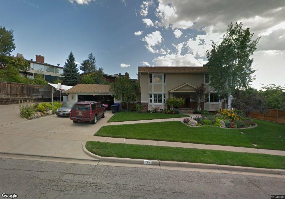
1224 Beverly Way Bountiful, UT 84010
Estimated Value: $847,000 - $918,000
6
Beds
3
Baths
4,109
Sq Ft
$215/Sq Ft
Est. Value
About This Home
This home is located at 1224 Beverly Way, Bountiful, UT 84010 and is currently estimated at $884,372, approximately $215 per square foot. 1224 Beverly Way is a home located in Davis County with nearby schools including Valley View School, Mueller Park Junior High School, and Bountiful High School.
Ownership History
Date
Name
Owned For
Owner Type
Purchase Details
Closed on
Jul 25, 2014
Sold by
Tayler Robert
Bought by
Tayler Robert L and Tayler Carol
Current Estimated Value
Home Financials for this Owner
Home Financials are based on the most recent Mortgage that was taken out on this home.
Original Mortgage
$242,250
Interest Rate
4.13%
Mortgage Type
Credit Line Revolving
Create a Home Valuation Report for This Property
The Home Valuation Report is an in-depth analysis detailing your home's value as well as a comparison with similar homes in the area
Purchase History
| Date | Buyer | Sale Price | Title Company |
|---|---|---|---|
| Tayler Robert L | -- | Lincoln Title Ins | |
| Tayler Robert | -- | Lincoln Title Insura |
Source: Public Records
Mortgage History
| Date | Status | Borrower | Loan Amount |
|---|---|---|---|
| Closed | Tayler Robert | $242,250 |
Source: Public Records
Tax History
| Year | Tax Paid | Tax Assessment Tax Assessment Total Assessment is a certain percentage of the fair market value that is determined by local assessors to be the total taxable value of land and additions on the property. | Land | Improvement |
|---|---|---|---|---|
| 2025 | $4,965 | $461,450 | $146,977 | $314,473 |
| 2024 | $4,652 | $444,950 | $135,301 | $309,649 |
| 2023 | $4,673 | $812,000 | $248,107 | $563,893 |
| 2022 | $4,690 | $446,600 | $132,504 | $314,096 |
| 2021 | $4,205 | $613,000 | $197,179 | $415,821 |
| 2020 | $3,727 | $546,000 | $179,480 | $366,520 |
| 2019 | $3,759 | $538,000 | $170,663 | $367,337 |
| 2018 | $3,606 | $509,000 | $159,357 | $349,643 |
| 2016 | $3,415 | $262,351 | $53,950 | $208,401 |
| 2015 | $3,368 | $244,421 | $53,950 | $190,471 |
| 2014 | $3,085 | $229,092 | $53,950 | $175,142 |
| 2013 | -- | $163,031 | $61,366 | $101,665 |
Source: Public Records
Map
Nearby Homes
- 1888 S 1150 E
- 1087 Arlington Way
- 1785 1450 E
- 2115 S Ridgewood Way
- 994 Deborah Dr
- 2156 Elaine Dr
- 1735 S Temple Ct Unit 203
- 1812 S 900 E
- 1596 E Millbrook Way
- 2136 S 900 E
- 831 E San Simeon Way S
- 0 Bountiful Blvd
- 775 E 1500 S
- 1761 S Davis Blvd
- 761 San Simeon Way
- 795 Abby Ln Unit 5
- 1742 E Ridge Point Dr
- 631 E 1700 S
- 2768 S 1500 E
- 2768 E 1500
- 1945 Browns Park Dr
- 1236 Beverly Way
- 1967 Browns Park Dr
- 1243 Beverly Way
- 1223 Beverly Way
- 1263 Beverly Way
- 1987 Browns Park Dr
- 1260 Beverly Way
- 1234 Sundance Cir
- 1254 Sundance Cir
- 1946 Browns Park Dr
- 1270 Sundance Cir
- 1216 Sundance Cir
- 1968 Browns Park Dr
- 1283 Beverly Way
- 1296 Beverly Way
- 1930 Browns Park Dr
- 2007 Browns Park Dr
- 1988 Browns Park Dr
- 1272 Beverly Way
Your Personal Tour Guide
Ask me questions while you tour the home.