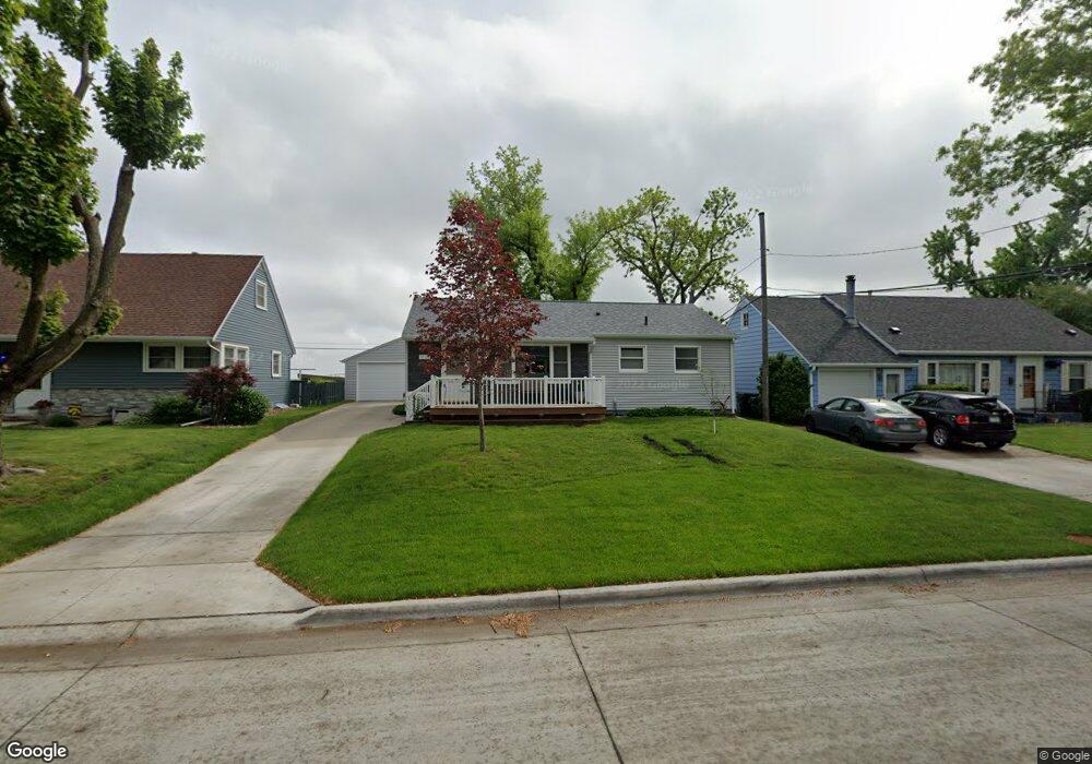
1225 20th St SW Cedar Rapids, IA 52404
Cleveland Area NeighborhoodEstimated Value: $172,000 - $215,000
3
Beds
2
Baths
1,040
Sq Ft
$184/Sq Ft
Est. Value
About This Home
This home is located at 1225 20th St SW, Cedar Rapids, IA 52404 and is currently estimated at $191,181, approximately $183 per square foot. 1225 20th St SW is a home located in Linn County with nearby schools including Junction City Elementary School, Cleveland Elementary School, and Kentucky Tech - Ashland Reg Tech Center.
Ownership History
Date
Name
Owned For
Owner Type
Purchase Details
Closed on
May 2, 2000
Sold by
Malloy William P and Malloy Donna M
Bought by
Clarke John and Estate Of Patricia Whited
Current Estimated Value
Home Financials for this Owner
Home Financials are based on the most recent Mortgage that was taken out on this home.
Original Mortgage
$72,900
Outstanding Balance
$25,402
Interest Rate
8.26%
Estimated Equity
$165,779
Purchase Details
Closed on
Apr 26, 2000
Sold by
Clarke John
Bought by
Ivins Michael W and Ivins Ramona J
Home Financials for this Owner
Home Financials are based on the most recent Mortgage that was taken out on this home.
Original Mortgage
$72,900
Outstanding Balance
$25,402
Interest Rate
8.26%
Estimated Equity
$165,779
Create a Home Valuation Report for This Property
The Home Valuation Report is an in-depth analysis detailing your home's value as well as a comparison with similar homes in the area
Home Values in the Area
Average Home Value in this Area
Purchase History
| Date | Buyer | Sale Price | Title Company |
|---|---|---|---|
| Clarke John | $39,000 | -- | |
| Ivins Michael W | $80,500 | -- |
Source: Public Records
Mortgage History
| Date | Status | Borrower | Loan Amount |
|---|---|---|---|
| Open | Ivins Michael W | $72,900 |
Source: Public Records
Tax History Compared to Growth
Tax History
| Year | Tax Paid | Tax Assessment Tax Assessment Total Assessment is a certain percentage of the fair market value that is determined by local assessors to be the total taxable value of land and additions on the property. | Land | Improvement |
|---|---|---|---|---|
| 2025 | $2,880 | $187,700 | $33,000 | $154,700 |
| 2024 | $2,870 | $176,400 | $30,000 | $146,400 |
| 2023 | $2,870 | $173,200 | $30,000 | $143,200 |
| 2022 | $2,674 | $144,900 | $25,500 | $119,400 |
| 2021 | $2,584 | $138,000 | $25,500 | $112,500 |
| 2020 | $2,584 | $125,700 | $24,000 | $101,700 |
| 2019 | $2,302 | $115,300 | $24,000 | $91,300 |
| 2018 | $2,234 | $115,300 | $24,000 | $91,300 |
| 2017 | $2,036 | $102,000 | $24,000 | $78,000 |
| 2016 | $2,115 | $99,500 | $24,000 | $75,500 |
| 2015 | $2,121 | $99,654 | $24,000 | $75,654 |
| 2014 | $1,936 | $102,840 | $24,000 | $78,840 |
| 2013 | $1,956 | $102,840 | $24,000 | $78,840 |
Source: Public Records
Map
Nearby Homes
- 1253 20th St SW
- 2178 Chandler St SW
- 1206 18th St SW
- 1807 9th Ave SW
- Remington - Cedar Rapids Plan at Whispering Pines
- Copeland Plan at Whispering Pines
- Meadowbrook - Cedar Rapids Plan at Stags Leap Estates
- Caldwell Plan at Stags Leap Estates
- Concord - Cedar Rapids Plan at Stags Leap Estates
- Yuma Expanded Plan at Whispering Pines
- Becker II Plan at Kirkwood Village - Kirk Wood Village
- Meadowbrook - Cedar Rapids Plan at Whispering Pines
- Richland Plan at Stags Leap Estates
- Prescott - Cedar Rapids Plan at Stags Leap Estates
- Becker Plan at Kirkwood Village - Kirk Wood Village
- Bakersfield - Cedar Rapids Plan at Whispering Pines
- Cedar Plan at Stags Leap Estates
- Becker - Cedar Rapids Plan at Whispering Pines
- Becker II - Cedar Rapids Plan at Whispering Pines
- Becker II - Cedar Rapids Plan at Stags Leap Estates
- 1217 20th St SW
- 1229 20th St SW
- 1213 20th St SW
- 1233 20th St SW
- 1201 20th St SW
- 1237 20th St SW
- 1224 20th St SW
- 1218 20th St SW
- 1228 20th St SW
- 1212 20th St SW
- 1232 20th St SW
- 1125 20th St SW
- 1241 20th St SW
- 1206 20th St SW
- 1236 20th St SW
- 1115 20th St SW
- 1240 20th St SW
- 1200 20th St SW
- 1245 20th St SW
- 2205 Chandler St SW