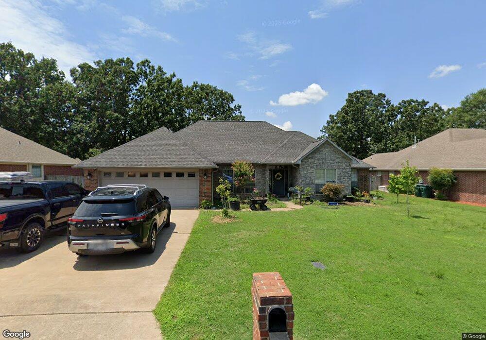
1225 Clarence Dr Conway, AR 72034
Estimated Value: $327,015 - $345,000
Studio
2
Baths
2,126
Sq Ft
$160/Sq Ft
Est. Value
About This Home
This home is located at 1225 Clarence Dr, Conway, AR 72034 and is currently estimated at $339,504, approximately $159 per square foot. 1225 Clarence Dr is a home located in Faulkner County with nearby schools including Ellen Smith Elementary School, Bob Courtway Middle School, and Conway Junior High School.
Ownership History
Date
Name
Owned For
Owner Type
Purchase Details
Closed on
May 8, 2015
Sold by
Chandler Ryan H and Chandler Jill S
Bought by
Huston Sean and Huston Nicole
Current Estimated Value
Home Financials for this Owner
Home Financials are based on the most recent Mortgage that was taken out on this home.
Original Mortgage
$197,359
Outstanding Balance
$149,176
Interest Rate
3.25%
Mortgage Type
FHA
Estimated Equity
$190,328
Purchase Details
Closed on
May 23, 2008
Bought by
Chandler
Home Financials for this Owner
Home Financials are based on the most recent Mortgage that was taken out on this home.
Original Mortgage
$188,510
Interest Rate
6.07%
Mortgage Type
FHA
Purchase Details
Closed on
Nov 27, 2001
Bought by
Moix
Create a Home Valuation Report for This Property
The Home Valuation Report is an in-depth analysis detailing your home's value as well as a comparison with similar homes in the area
Home Values in the Area
Average Home Value in this Area
Purchase History
| Date | Buyer | Sale Price | Title Company |
|---|---|---|---|
| Huston Sean | $201,000 | None Available | |
| Chandler | $190,000 | -- | |
| Chandler Ryan H | $190,000 | Lenders Title Co | |
| Moix | $21,000 | -- |
Source: Public Records
Mortgage History
| Date | Status | Borrower | Loan Amount |
|---|---|---|---|
| Open | Huston Sean | $197,359 | |
| Previous Owner | Chandler Ryan H | $188,510 |
Source: Public Records
Tax History
| Year | Tax Paid | Tax Assessment Tax Assessment Total Assessment is a certain percentage of the fair market value that is determined by local assessors to be the total taxable value of land and additions on the property. | Land | Improvement |
|---|---|---|---|---|
| 2025 | $2,502 | $62,240 | $7,200 | $55,040 |
| 2024 | $2,388 | $62,240 | $7,200 | $55,040 |
| 2023 | $2,274 | $44,940 | $7,200 | $37,740 |
| 2022 | $1,840 | $44,940 | $7,200 | $37,740 |
| 2021 | $1,739 | $44,940 | $7,200 | $37,740 |
| 2020 | $1,638 | $39,790 | $7,200 | $32,590 |
| 2019 | $1,638 | $39,790 | $7,200 | $32,590 |
| 2018 | $1,663 | $39,790 | $7,200 | $32,590 |
| 2017 | $1,663 | $39,790 | $7,200 | $32,590 |
| 2016 | $1,663 | $39,790 | $7,200 | $32,590 |
| 2015 | $1,951 | $38,560 | $7,200 | $31,360 |
| 2014 | $1,601 | $38,560 | $7,200 | $31,360 |
Source: Public Records
Map
Nearby Homes
- 1145 Trenton Dr
- 1320 Andy Dr
- 2125 Rosemary Dr
- 1450 Ronnie Weaver Dr
- 2455 Wilmington Dr
- 2515 Eighteen Loop
- 2535 Eighteen Loop
- 2342 Holly Hill Dr
- 00 Sagegrass
- 2321 Bridgegate Dr
- 954 Joseph Dr
- 1340 Biltmore Gardens
- 953 Joseph Dr
- 2730 Stone Wood Dr
- 2575 Forest View Dr
- 2800 Wineberry
- 1630 Jasmine Ln
- 1535 Blustery Way
- 1510 Arden Ln
- 1630 S Donaghey Ave
- 1235 Clarence Dr
- 1215 Clarence Dr
- 1310 Norbert Cir
- 1305 Clarence Dr
- 1220 Clarence Dr
- 1230 Clarence Dr
- 1300 Norbert Cir
- 1205 Clarence Dr
- 1320 Norbert Cir
- 1310 Clarence Dr
- 1210 Clarence Dr
- 1140 Spatz Cir
- 1315 Clarence Dr
- 1135 Clarence Dr
- 1305 Norbert Cir
- 1130 Spatz Cir
- 1140 Clarence Dr
- 1330 Norbert Cir
- 0 Spatz Cir
- 1320 Clarence Dr
Your Personal Tour Guide
Ask me questions while you tour the home.