


1226 Polk St S Shakopee, MN 55379
Estimated payment $1,544/month
Highlights
- No HOA
- The kitchen features windows
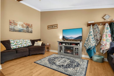
- Living Room
- Shakopee Senior High School Rated A-
- Porch
- Forced Air Heating and Cooling System
About This Home
Step inside this beautiful home featuring a new AC, furnace, water heater, water softener, garbage disposal, and updated garage door mechanisms for peace of mind. Fresh updates throughout include painted bedrooms, stylish wallpaper accents, a new bathroom vanity, sink, and mirror, giving the home a refreshed, move-in-ready feel. Enjoy both comfort and character with a screen porch off the primary bedroom, a cozy lower-level fireplace, and plenty of outdoor living space with a patio, fenced-in yard, and refreshed landscaping in the front and back yards. Practical upgrades pair perfectly with charming features, making this home truly stand out. With no HOA fees, you’ll enjoy the freedom of homeownership without added costs.
Townhouse Details
Home Type
- Townhome
Est. Annual Taxes
- $2,260
Year Built
- Built in 1981
Lot Details
- 3,049 Sq Ft Lot
- Wood Fence
- Many Trees
Parking
- 2 Car Garage
- Garage Door Opener
Home Design
- Pitched Roof
- Vinyl Siding
Interior Spaces
- 2-Story Property
- Wood Burning Fireplace
- Family Room with Fireplace
- Living Room
- Dryer
Kitchen
- Range
- Microwave
- Dishwasher
- Disposal
- The kitchen features windows
Bedrooms and Bathrooms
- 2 Bedrooms
Finished Basement
- Crawl Space
- Natural lighting in basement
Outdoor Features
- Porch
Utilities
- Forced Air Heating and Cooling System
- Water Softener is Owned
Community Details
- No Home Owners Association
Listing and Financial Details
- Assessor Parcel Number 270840331
Map
Home Values in the Area
Average Home Value in this Area
Tax History
| Year | Tax Paid | Tax Assessment Tax Assessment Total Assessment is a certain percentage of the fair market value that is determined by local assessors to be the total taxable value of land and additions on the property. | Land | Improvement |
|---|---|---|---|---|
| 2025 | $2,260 | $252,000 | $106,500 | $145,500 |
| 2024 | $2,330 | $234,500 | $101,400 | $133,100 |
| 2023 | $2,394 | $230,300 | $99,400 | $130,900 |
| 2022 | $2,044 | $232,800 | $101,800 | $131,000 |
| 2021 | $1,668 | $177,300 | $79,800 | $97,500 |
| 2020 | $1,936 | $163,300 | $73,500 | $89,800 |
| 2019 | $1,926 | $166,400 | $77,700 | $88,700 |
| 2018 | $2,234 | $0 | $0 | $0 |
| 2016 | $2,180 | $0 | $0 | $0 |
| 2014 | -- | $0 | $0 | $0 |
Property History
| Date | Event | Price | List to Sale | Price per Sq Ft |
|---|---|---|---|---|
| 11/07/2025 11/07/25 | Price Changed | $257,900 | -3.0% | $176 / Sq Ft |
| 10/28/2025 10/28/25 | Price Changed | $265,900 | -1.5% | $181 / Sq Ft |
| 10/08/2025 10/08/25 | For Sale | $269,900 | -- | $184 / Sq Ft |
Purchase History
| Date | Type | Sale Price | Title Company |
|---|---|---|---|
| Warranty Deed | $190,000 | First American Title Ins Co | |
| Warranty Deed | $152,000 | Title Recording Services Inc | |
| Warranty Deed | $125,000 | -- |
Mortgage History
| Date | Status | Loan Amount | Loan Type |
|---|---|---|---|
| Open | $184,300 | New Conventional | |
| Previous Owner | $149,246 | FHA |
Source: NorthstarMLS
MLS Number: 6755794
APN: 27-084-033-1
Disclaimer: Certain information contained herein is derived from information provided by parties other than Homes.com. All information provided is deemed reliable, but is not guaranteed to be accurate and should be independently verified.
![]() Based on information submitted to the MLS GRID. All data is obtained from various sources and may not have been verified by broker or MLS GRID. Supplied Open House Information is subject to change without notice. All information should be independently reviewed and verified for accuracy. Properties may or may not be listed by the office/agent presenting the information. Some IDX listings have been excluded from this website.
Based on information submitted to the MLS GRID. All data is obtained from various sources and may not have been verified by broker or MLS GRID. Supplied Open House Information is subject to change without notice. All information should be independently reviewed and verified for accuracy. Properties may or may not be listed by the office/agent presenting the information. Some IDX listings have been excluded from this website.
The Digital Millennium Copyright Act of 1998, 17 U.S.C. § 512 (the “DMCA”) provides recourse for copyright owners who believe that material appearing on the Internet infringes their rights under U.S. copyright law. If you believe in good faith that any content or material made available in connection with our website or services infringes your copyright, you (or your agent) may send us a notice requesting that the content or material be removed, or access to it blocked.
Notices must be sent in writing by email to DMCAnotice@MLSGrid.com.
The DMCA requires that your notice of alleged copyright infringement include the following information:
(1) description of the copyrighted work that is the subject of claimed infringement;
(2) description of the alleged infringing content and information sufficient to permit us to locate the content;
(3) contact information for you, including your address, telephone number and email address;
(4) a statement by you that you have a good faith belief that the content in the manner complained of is not authorized by the copyright owner, or its agent, or by the operation of any law;
(5) a statement by you, signed under penalty of perjury, that the information in the notification is accurate and that you have the authority to enforce the copyrights that are claimed to be infringed; and
(6) a physical or electronic signature of the copyright owner or a person authorized to act on the copyright owner’s behalf. Failure to include all of the above information may result in the delay of the processing of your complaint.
- 1259 Taylor St Unit 3
- 1279 Taylor St Unit 5
- 2224 Quarry Ln
- 1853 Stone Meadow Blvd
- 1187 Jackson St S
- 2007 10th Ave W Unit 12
- 1813 6th Ave W
- 1690 Windigo Ln
- 816 Regent Dr
- 1861 Attenborough St
- The Ferguson Plan at Bluff View - Cottage Series
- The Edison Plan at Bluff View - Cottage Series
- The Tatum Plan at Bluff View - Cottage Series
- The Pattison Plan at Bluff View - Cottage Series
- The Harmony Plan at Bluff View - Freedom Series
- The Dover II Plan at Bluff View - Freedom Series
- The Clifton II Plan at Bluff View - Freedom Series
- The Cali Plan at Bluff View - Freedom Series
- 1179 Cubasue Ct
- 696 Jutland Ave
- 1219-1229 Taylor St
- 1220 Taylor St
- 1600 Windermere Way
- 1601 Harvest Ln
- 1619 Windigo Ln
- 1620 Lusitano St
- 730 Pierce St S
- 125 Scott St N
- 125 6th Ave E
- 500 Sommerville St S
- 335 Shakopee Ave E
- 129 Holmes St S
- 101 Fuller St N
- 1220 Stoughton Ave
- 1220 Stoughton Ave Unit 1220
- 205 1st Ave E
- 931 Market St S
- 118 S Shannon Dr
- 676 Cobblestone Way
- 609 Market St S
