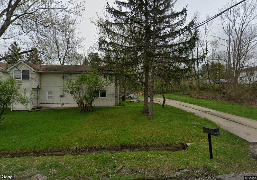
12287 Laurel Dr Newbury, OH 44065
Estimated Value: $276,000 - $333,000
4
Beds
2
Baths
2,448
Sq Ft
$125/Sq Ft
Est. Value
About This Home
This home is located at 12287 Laurel Dr, Newbury, OH 44065 and is currently estimated at $306,837, approximately $125 per square foot. 12287 Laurel Dr is a home located in Geauga County with nearby schools including Notre Dame Elementary School.
Ownership History
Date
Name
Owned For
Owner Type
Purchase Details
Closed on
May 25, 2016
Sold by
Stotlar Deloris J and Stotlar Jean
Bought by
Wheeler Matthew Brian and Hollowell Linda Ann
Current Estimated Value
Home Financials for this Owner
Home Financials are based on the most recent Mortgage that was taken out on this home.
Original Mortgage
$145,000
Outstanding Balance
$115,441
Interest Rate
3.58%
Mortgage Type
New Conventional
Estimated Equity
$191,396
Purchase Details
Closed on
Jan 1, 1990
Bought by
Stotlar Clair D and Stotlar Delores J
Create a Home Valuation Report for This Property
The Home Valuation Report is an in-depth analysis detailing your home's value as well as a comparison with similar homes in the area
Home Values in the Area
Average Home Value in this Area
Purchase History
| Date | Buyer | Sale Price | Title Company |
|---|---|---|---|
| Wheeler Matthew Brian | $195,000 | Lawyers Title Of Chardon | |
| Stotlar Clair D | -- | -- |
Source: Public Records
Mortgage History
| Date | Status | Borrower | Loan Amount |
|---|---|---|---|
| Open | Wheeler Matthew Brian | $145,000 |
Source: Public Records
Tax History Compared to Growth
Tax History
| Year | Tax Paid | Tax Assessment Tax Assessment Total Assessment is a certain percentage of the fair market value that is determined by local assessors to be the total taxable value of land and additions on the property. | Land | Improvement |
|---|---|---|---|---|
| 2024 | $3,807 | $92,400 | $16,730 | $75,670 |
| 2023 | $3,807 | $92,400 | $16,730 | $75,670 |
| 2022 | $3,496 | $72,210 | $13,930 | $58,280 |
| 2021 | $3,485 | $72,210 | $13,930 | $58,280 |
| 2020 | $3,205 | $72,210 | $13,930 | $58,280 |
| 2019 | $3,940 | $64,160 | $13,930 | $50,230 |
| 2018 | $3,932 | $64,160 | $13,930 | $50,230 |
| 2017 | $3,940 | $64,160 | $13,930 | $50,230 |
| 2016 | $2,854 | $54,850 | $11,550 | $43,300 |
| 2015 | $2,852 | $54,850 | $11,550 | $43,300 |
| 2014 | $2,781 | $54,850 | $11,550 | $43,300 |
| 2013 | $2,441 | $54,850 | $11,550 | $43,300 |
Source: Public Records
Map
Nearby Homes
- 8 Sperry Rd
- 14525 Sperry Rd
- 13655 Sperry Rd
- 13610 Sperry Rd
- 10978 Fairmount Rd
- 13228 Boulder Glen Dr
- 14300 Watt Rd
- 10885 Scranton Woods Trail
- 14957 Sperry Rd
- 10685 Butternut Rd
- 14646 Dora Dr
- 9613 Kim Dr
- 9502 Winchester Valley
- 10263 Wye Rd
- 11100 Pekin Rd
- 13559 Auburn Rd
- 8986 Fairmount Rd
- 13190 N Bridle Trail
- 13410 Auburn Rd
- 14545 Shire Ct
- 10011 Fairmount Rd
- 10170 Pekin Rd
- 10133 Fairmount Rd
- 10063 Fairmount Rd
- 10180 Pekin Rd
- 10155 Fairmount Rd
- 10167 Fairmount Rd
- 10084 Fairmount Rd
- Parcel 2 Fairmount Rd
- 10142 Fairmount Rd
- 10191 Fairmount Rd
- 10108 Fairmount Rd
- SL 3 Fairmount Rd
- S/L 2B Fairmount Rd
- S/L 1A Fairmount Rd
- Parcel 1 Fairmount Rd
- 10010 Fairmount Rd
- Parcel 3 Fairmount Rd
- 10223 Fairmount Rd
- 10160 Fairmount Rd