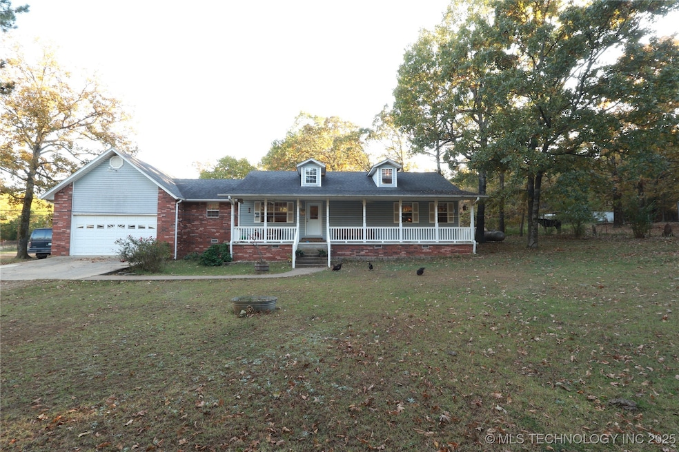
12293 E 590 Rd Locust Grove, OK 74352
Estimated payment $2,585/month
Highlights
- Hot Property
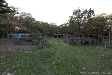
- Horses Allowed On Property
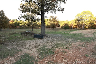
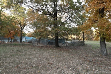
- 20 Acre Lot
- Barn
- RV Access or Parking
- Fruit Trees
About This Home
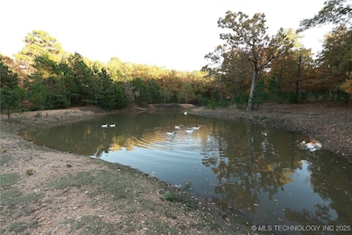
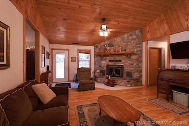
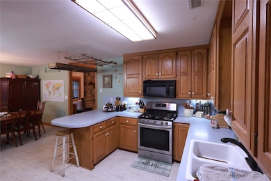
Stunning Custom-Built Home on 20± Acres – Country Living at Its Best! Beautiful 3-bed, 2.5-bath custom home on 20± acres w/bonus attic office. Vaulted LR w/knotty pine & river rock FP heats home. Oak cabinets, pantry, Pergo floors. Primary: dbl sinks, whirlpool; all beds WIC. Cellar under kitchen via 1-car garage. New septic '25; 50-gal WH '21. Seller to install new central H&A before closing. Fenced w/pond, big shop, storage, pens for small animals & large corral. Ideal hobby farm! Won’t last.
Home Details
Home Type
- Single Family
Est. Annual Taxes
- $349
Year Built
- Built in 1998
Lot Details
- 20 Acre Lot
- North Facing Home
- Dog Run
- Cross Fenced
- Barbed Wire
- Electric Fence
- Pipe Fencing
- Fruit Trees
- Mature Trees
Parking
- 1 Car Attached Garage
- Parking Storage or Cabinetry
- Workshop in Garage
- Gravel Driveway
- RV Access or Parking
Home Design
- Brick Veneer
- Wood Frame Construction
- Fiberglass Roof
- Vinyl Siding
- Asphalt
Interior Spaces
- 1,730 Sq Ft Home
- 1-Story Property
- Wired For Data
- Vaulted Ceiling
- Ceiling Fan
- Wood Burning Fireplace
- Self Contained Fireplace Unit Or Insert
- Fireplace With Glass Doors
- Fireplace Features Blower Fan
- Aluminum Window Frames
- Crawl Space
- Washer and Gas Dryer Hookup
- Attic
Kitchen
- Stove
- Range
- Microwave
- Ice Maker
- Dishwasher
- Laminate Countertops
Flooring
- Laminate
- Tile
- Vinyl
Bedrooms and Bathrooms
- 3 Bedrooms
- Soaking Tub
Home Security
- Storm Windows
- Storm Doors
- Fire and Smoke Detector
Outdoor Features
- Covered Patio or Porch
- Separate Outdoor Workshop
- Shed
- Storm Cellar or Shelter
- Rain Gutters
Schools
- Locust Grove Elementary School
- Locust Grove High School
Utilities
- Zoned Heating and Cooling
- Propane
- Agricultural Well Water Source
- Gas Water Heater
- Septic Tank
- High Speed Internet
- Phone Available
Additional Features
- Barn
- Horses Allowed On Property
Community Details
- No Home Owners Association
- Cherokee Co Unplatted Subdivision
Map
Home Values in the Area
Average Home Value in this Area
Tax History
| Year | Tax Paid | Tax Assessment Tax Assessment Total Assessment is a certain percentage of the fair market value that is determined by local assessors to be the total taxable value of land and additions on the property. | Land | Improvement |
|---|---|---|---|---|
| 2025 | $2,820 | $41,482 | $6,150 | $35,332 |
| 2024 | $2,820 | $39,507 | $5,858 | $33,649 |
| 2023 | $2,820 | $37,626 | $5,858 | $31,768 |
| 2022 | $2,729 | $38,225 | $3,010 | $35,215 |
| 2021 | $362 | $6,073 | $864 | $5,209 |
| 2020 | $349 | $5,895 | $838 | $5,057 |
| 2019 | $337 | $5,723 | $814 | $4,909 |
| 2018 | $325 | $5,557 | $790 | $4,767 |
| 2017 | $314 | $5,395 | $569 | $4,826 |
| 2016 | $303 | $5,238 | $600 | $4,638 |
| 2015 | $274 | $5,085 | $2,640 | $2,445 |
| 2014 | $274 | $4,937 | $2,640 | $2,297 |
Property History
| Date | Event | Price | List to Sale | Price per Sq Ft |
|---|---|---|---|---|
| 11/06/2025 11/06/25 | For Sale | $485,000 | -- | $280 / Sq Ft |
Purchase History
| Date | Type | Sale Price | Title Company |
|---|---|---|---|
| Warranty Deed | $347,500 | Fidelity National Ttl Ins Co |
Mortgage History
| Date | Status | Loan Amount | Loan Type |
|---|---|---|---|
| Open | $278,000 | New Conventional |
Source: MLS Technology
MLS Number: 2546167
APN: 0000-04-19N-21E-0-015-00
Disclaimer: Certain information contained herein is derived from information provided by parties other than Homes.com. All information provided is deemed reliable, but is not guaranteed to be accurate and should be independently verified.
![]() IDX information is provided exclusively for personal, non-commercial use, and may not be used for any purpose other than to identify prospective properties consumers may be interested in purchasing.
IDX information is provided exclusively for personal, non-commercial use, and may not be used for any purpose other than to identify prospective properties consumers may be interested in purchasing.
Information is deemed reliable but not guaranteed.
- 10761 E 590 Rd
- 0 E 590 Rd Unit 2538744
- 11377 E 590
- TBD SE 575
- 9212 S 443 Rd
- 12729 E 580 Rd
- 7742 S 447 Rd
- 0 E 630 Rd Unit 2527536
- 7383 S 447 Rd
- 12665 S 4429
- 4100 N 430 Rd
- 5545 E 412
- 12809 E Highway 412
- 7864 S 449 Rd
- 7167 E 618 Rd
- 11366 U S 412
- 0 E 610 Rd Unit 2542638
- 12754 S 442 Rd
- 0 U S 412 Alternate
- 6959 E 561 Rd
