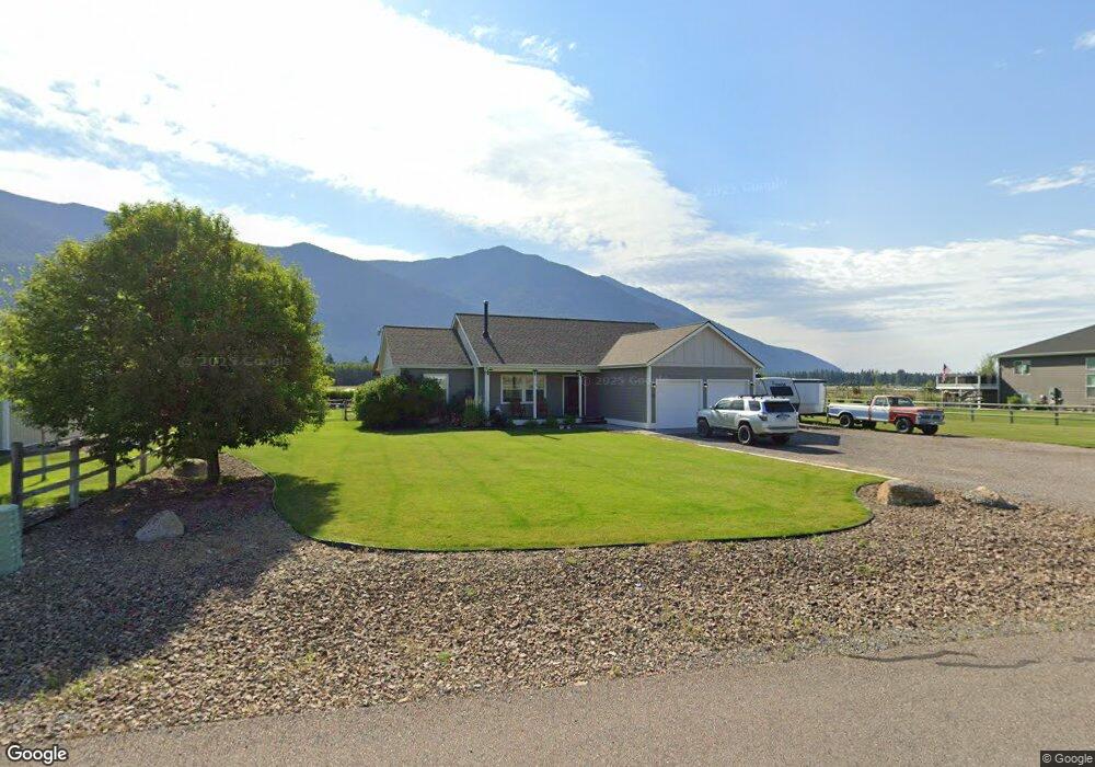
123 Columbia Range Dr Columbia Falls, MT 59912
Estimated Value: $591,534 - $700,000
3
Beds
2
Baths
1,526
Sq Ft
$437/Sq Ft
Est. Value
About This Home
This home is located at 123 Columbia Range Dr, Columbia Falls, MT 59912 and is currently estimated at $666,134, approximately $436 per square foot. 123 Columbia Range Dr is a home located in Flathead County with nearby schools including Deer Park Elementary School, Deer Park Junior High School, and Flathead High School.
Ownership History
Date
Name
Owned For
Owner Type
Purchase Details
Closed on
Nov 9, 2021
Sold by
Wilson William J
Bought by
Wilson William J and Wilson Heather Anne
Current Estimated Value
Home Financials for this Owner
Home Financials are based on the most recent Mortgage that was taken out on this home.
Original Mortgage
$308,400
Outstanding Balance
$262,625
Interest Rate
2.99%
Mortgage Type
New Conventional
Estimated Equity
$403,509
Purchase Details
Closed on
Nov 2, 2009
Sold by
Valley View Investments Llc
Bought by
Wilson William J
Home Financials for this Owner
Home Financials are based on the most recent Mortgage that was taken out on this home.
Original Mortgage
$214,626
Interest Rate
5%
Mortgage Type
FHA
Purchase Details
Closed on
Aug 31, 2009
Sold by
Valley Wide Investments Llc
Bought by
Hoye Cora
Create a Home Valuation Report for This Property
The Home Valuation Report is an in-depth analysis detailing your home's value as well as a comparison with similar homes in the area
Home Values in the Area
Average Home Value in this Area
Purchase History
| Date | Buyer | Sale Price | Title Company |
|---|---|---|---|
| Wilson William J | -- | Insured Titles | |
| Wilson William J | -- | First American Title Company | |
| Hoye Cora | -- | First American Title Company |
Source: Public Records
Mortgage History
| Date | Status | Borrower | Loan Amount |
|---|---|---|---|
| Open | Wilson William J | $308,400 | |
| Closed | Wilson William J | $214,626 |
Source: Public Records
Tax History Compared to Growth
Tax History
| Year | Tax Paid | Tax Assessment Tax Assessment Total Assessment is a certain percentage of the fair market value that is determined by local assessors to be the total taxable value of land and additions on the property. | Land | Improvement |
|---|---|---|---|---|
| 2025 | $1,733 | $567,700 | $0 | $0 |
| 2024 | $2,310 | $463,400 | $0 | $0 |
| 2023 | $2,386 | $463,400 | $0 | $0 |
| 2022 | $2,187 | $315,100 | $0 | $0 |
| 2021 | $2,201 | $315,100 | $0 | $0 |
| 2020 | $2,032 | $272,600 | $0 | $0 |
| 2019 | $1,995 | $272,600 | $0 | $0 |
| 2018 | $1,832 | $235,100 | $0 | $0 |
| 2017 | $1,723 | $235,100 | $0 | $0 |
| 2016 | $1,588 | $199,300 | $0 | $0 |
| 2015 | $1,617 | $199,300 | $0 | $0 |
| 2014 | $1,311 | $95,135 | $0 | $0 |
Source: Public Records
Map
Nearby Homes
- 154 Columbia Range Dr
- 2360 Montana Highway 206
- 128 Back Forty View
- Nhn Trap Rd
- 597 Eckelberry Dr
- 2247 Montana Highway 206
- 300 Jay Hawk Ln
- 183 Middle View Trail
- 240 Elk Park Rd
- 556 Windy Acres Dr
- 109 Greenwald Ln
- 125 Greenwald Ln
- 474 Trap Rd
- 1955 Mt Highway 206
- 1930 Montana Highway 206
- 147 Patriots Ln
- 271 Patriots Ln
- 255 Patriots Ln
- 211 Patriots Ln
- 189 Patriots Ln
- 107 Columbia Range Dr
- 135 Columbia Range Dr
- 12 Columbia Range Dr
- 130 Columbia Range Dr
- 16 Columbia Range Dr
- 147 Columbia Range Dr
- 15 Columbia Range Dr
- 3 Columbia Range Dr
- 13 Columbia Range Dr
- 11 Columbia Range Dr
- 110 Columbia Range Dr
- Lot 12 Columbia Range Dr
- 159 Columbia Range Dr
- 142 Columbia Range Dr
- NHN Columbia Range Dr
- 171 Columbia Range Dr
- 222 Columbia Range Dr
- 189 Midnight Ln
- 183 Columbia Range Dr
- Nhn Eckelberry Dr