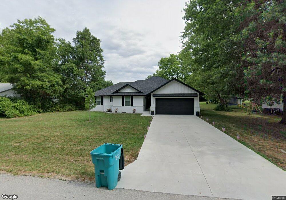
123 E Brooks St Republic, MO 65738
Estimated Value: $227,000 - $265,239
3
Beds
2
Baths
1,419
Sq Ft
$174/Sq Ft
Est. Value
About This Home
This home is located at 123 E Brooks St, Republic, MO 65738 and is currently estimated at $247,060, approximately $174 per square foot. 123 E Brooks St is a home with nearby schools including Lyon Elementary School, Republic Middle School, and Republic High School.
Ownership History
Date
Name
Owned For
Owner Type
Purchase Details
Closed on
Dec 3, 2021
Sold by
Kneadmore Dough Llc
Bought by
Wolfe Krista and Wolfe Ethan
Current Estimated Value
Home Financials for this Owner
Home Financials are based on the most recent Mortgage that was taken out on this home.
Original Mortgage
$163,400
Outstanding Balance
$150,245
Interest Rate
3.09%
Mortgage Type
New Conventional
Estimated Equity
$96,815
Purchase Details
Closed on
Sep 15, 2021
Sold by
Minier Earline Sue
Bought by
Minier Llc
Purchase Details
Closed on
Jun 15, 2021
Sold by
Cole Darin W and Cole Kimberly K
Bought by
Kneadmore Dough Llc
Create a Home Valuation Report for This Property
The Home Valuation Report is an in-depth analysis detailing your home's value as well as a comparison with similar homes in the area
Home Values in the Area
Average Home Value in this Area
Purchase History
| Date | Buyer | Sale Price | Title Company |
|---|---|---|---|
| Wolfe Krista | -- | None Listed On Document | |
| Minier Llc | -- | None Listed On Document | |
| Kneadmore Dough Llc | -- | None Available | |
| Kneadmore Dough Llc | -- | None Listed On Document |
Source: Public Records
Mortgage History
| Date | Status | Borrower | Loan Amount |
|---|---|---|---|
| Open | Wolfe Krista | $163,400 |
Source: Public Records
Tax History
| Year | Tax Paid | Tax Assessment Tax Assessment Total Assessment is a certain percentage of the fair market value that is determined by local assessors to be the total taxable value of land and additions on the property. | Land | Improvement |
|---|---|---|---|---|
| 2025 | $2,024 | $38,110 | $5,700 | $32,410 |
| 2024 | $1,881 | $33,670 | $4,750 | $28,920 |
| 2023 | $1,845 | $33,670 | $4,750 | $28,920 |
| 2022 | $1,570 | $28,520 | $4,750 | $23,770 |
| 2021 | $806 | $4,750 | $4,750 | $0 |
| 2020 | $264 | $4,750 | $4,750 | $0 |
| 2019 | $263 | $4,750 | $4,750 | $0 |
| 2018 | $218 | $3,800 | $3,800 | $0 |
| 2017 | $216 | $3,800 | $3,800 | $0 |
| 2016 | $218 | $3,800 | $3,800 | $0 |
| 2015 | $218 | $3,800 | $3,800 | $0 |
| 2014 | $220 | $3,800 | $3,800 | $0 |
Source: Public Records
Map
Nearby Homes
- 511 S Main Ave
- 0 Highway 60 Unit 60308100
- 0 Highway 60 Unit 60308095
- 421 W Elm St
- 425 E Harrison St
- 500 Ethan Ave
- 114 S Eagan St
- 1213 N London Place
- 307 W Granada St
- 975 S Montpelier Ct
- 319 W Hines St
- 144 S Redbud Ave
- 205 E Grace St
- 393 N Ladera Dr
- 526 W Logan St
- 513 W Logan St
- 101 E Grace St
- 636 N Dana Ave
- 647 N Dana Ave
- 1235 S Venice Ave
- 131 E Brooks St
- 117 E Brooks St
- 111 E Brooks St
- 124 E Brooks St
- 137 E Brooks St
- 128 E Brooks St
- 120 E Brooks St
- 230 S Main Ave
- 136 E Brooks St
- 302 S Main Ave
- 143 E Brooks St
- 000 E Brooks St
- 0000 E Brooks St
- 124 E Mill St
- 116 E Mill St
- 132 E Mill St
- 310 S Main Ave
- 142 E Brooks St
- 233 S Maple Ave
- 227 S Main Ave
Your Personal Tour Guide
Ask me questions while you tour the home.