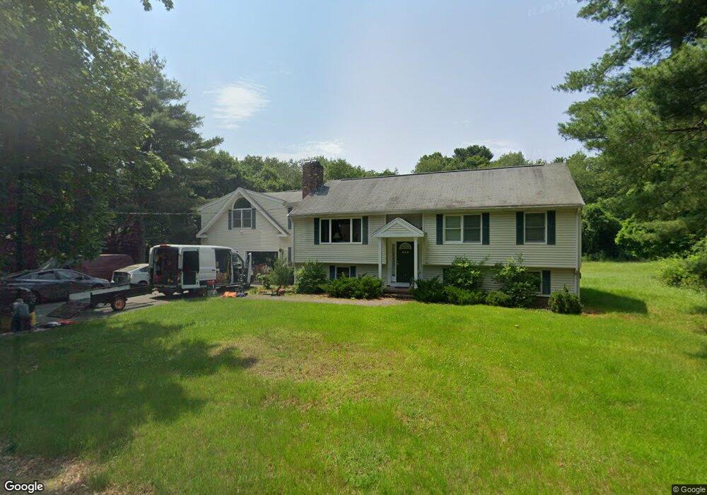
123 Mansfield St Sharon, MA 02067
Estimated Value: $793,000 - $892,000
3
Beds
2
Baths
2,260
Sq Ft
$372/Sq Ft
Est. Value
About This Home
This home is located at 123 Mansfield St, Sharon, MA 02067 and is currently estimated at $840,160, approximately $371 per square foot. 123 Mansfield St is a home located in Norfolk County with nearby schools including Heights Elementary School, Sharon Middle School, and Sharon High School.
Ownership History
Date
Name
Owned For
Owner Type
Purchase Details
Closed on
Apr 25, 2019
Sold by
Barron James A and Delpadre Camille
Bought by
Del Padre & Barron Ft
Current Estimated Value
Purchase Details
Closed on
Oct 5, 2018
Sold by
Delpadre & Barron Ft
Bought by
Delapdre Camille and Barron James A
Purchase Details
Closed on
Sep 14, 2009
Sold by
Barron James A and Delpadre Camille P
Bought by
Barron James A and Delpadre Camille P
Purchase Details
Closed on
Aug 28, 2008
Sold by
Barron James A
Bought by
Delpadre Camille and Barron James A
Create a Home Valuation Report for This Property
The Home Valuation Report is an in-depth analysis detailing your home's value as well as a comparison with similar homes in the area
Home Values in the Area
Average Home Value in this Area
Purchase History
| Date | Buyer | Sale Price | Title Company |
|---|---|---|---|
| Del Padre & Barron Ft | -- | None Available | |
| Delapdre Camille | -- | -- | |
| Barron James A | -- | -- | |
| Delpadre Camille | -- | -- |
Source: Public Records
Tax History Compared to Growth
Tax History
| Year | Tax Paid | Tax Assessment Tax Assessment Total Assessment is a certain percentage of the fair market value that is determined by local assessors to be the total taxable value of land and additions on the property. | Land | Improvement |
|---|---|---|---|---|
| 2025 | $11,418 | $653,200 | $402,800 | $250,400 |
| 2024 | $11,012 | $626,400 | $369,600 | $256,800 |
| 2023 | $10,756 | $578,600 | $345,500 | $233,100 |
| 2022 | $10,456 | $529,400 | $287,900 | $241,500 |
| 2021 | $10,387 | $508,400 | $271,500 | $236,900 |
| 2020 | $9,660 | $508,400 | $271,500 | $236,900 |
| 2019 | $9,261 | $477,100 | $240,200 | $236,900 |
| 2018 | $9,152 | $472,500 | $235,600 | $236,900 |
| 2017 | $8,970 | $457,200 | $220,300 | $236,900 |
| 2016 | $8,776 | $436,400 | $220,300 | $216,100 |
| 2015 | $8,217 | $404,800 | $202,000 | $202,800 |
| 2014 | $7,612 | $370,400 | $183,700 | $186,700 |
Source: Public Records
Map
Nearby Homes
- 2 Red Fox Run
- 3 Wampanoag Rd
- 186 Morse St
- Lot One Old Wolomolopoag St
- Lot Two Old Wolomolopoag St
- 260 Massapoag Ave
- 5 Chase Dr
- 12 Community Way
- 285 Massapoag Ave
- 35 Independence Dr Unit 35
- 170 Cannon Forge Dr
- 132 Cannon Forge Dr
- 9 Independence Dr Unit 9
- 218 Massapoag Ave
- 261 East St
- 33 Longmeadow Ln
- 3 Nicole Rd
- 89 Oak St
- 376 Mountain St
- 350 Mountain St
- 103 Mansfield St
- 131 Mansfield St
- 118 Mansfield St
- 108 Mansfield St
- 128 Mansfield St
- 93 Mansfield St
- 93 Mansfield St
- 98 Mansfield St
- 139 Mansfield St
- 130 Mansfield St
- 88 Mansfield St
- 81 Mansfield St
- 5 Solstice Way
- 136 Mansfield St
- 145 Mansfield St
- 78 Mansfield St
- Lot 2 Solstice Way
- 3 Solstice Way
- Lot 1 Solstice Way
- 2 Solstice Way