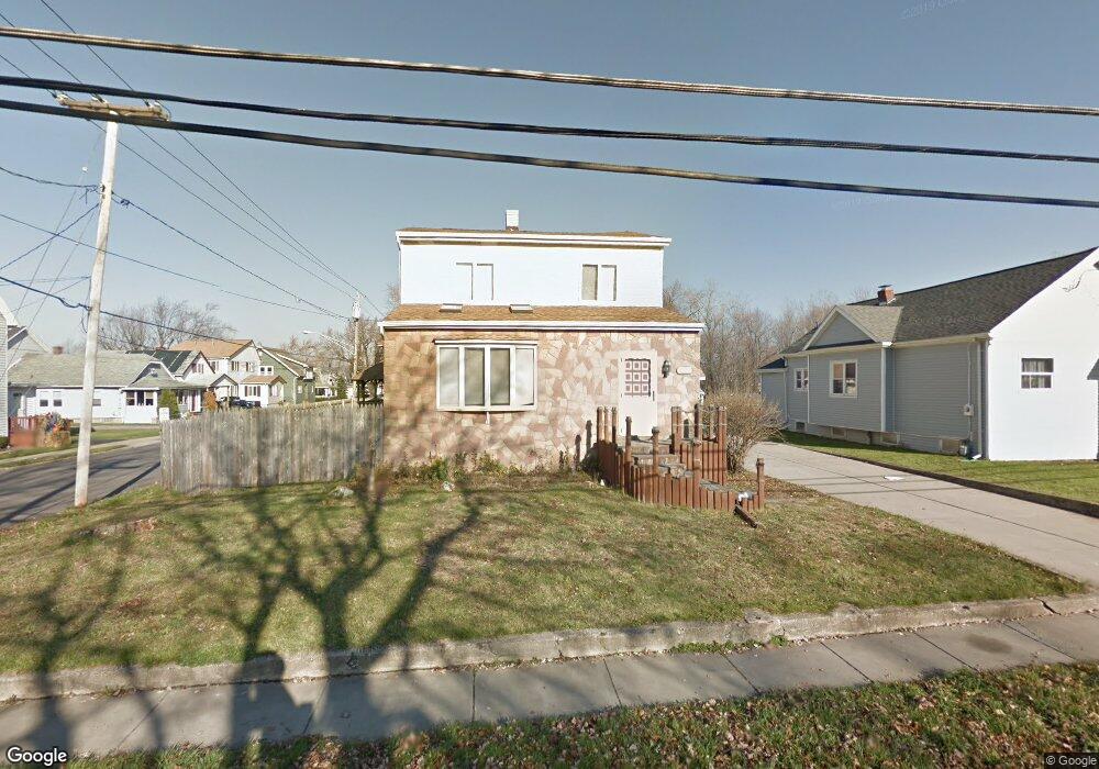
123 Maple Ave Buffalo, NY 14219
Estimated Value: $261,078 - $348,000
3
Beds
1
Bath
1,674
Sq Ft
$175/Sq Ft
Est. Value
About This Home
This home is located at 123 Maple Ave, Buffalo, NY 14219 and is currently estimated at $292,270, approximately $174 per square foot. 123 Maple Ave is a home located in Erie County with nearby schools including Blasdell Elementary School, Frontier Middle School, and Frontier Senior High School.
Ownership History
Date
Name
Owned For
Owner Type
Purchase Details
Closed on
Oct 4, 2003
Sold by
Buchholz Joseph David and Buchholz Carol Ann
Bought by
Davis Matthew E and Lux Melissa M
Current Estimated Value
Home Financials for this Owner
Home Financials are based on the most recent Mortgage that was taken out on this home.
Original Mortgage
$88,000
Outstanding Balance
$41,685
Interest Rate
6.43%
Mortgage Type
Purchase Money Mortgage
Estimated Equity
$250,585
Create a Home Valuation Report for This Property
The Home Valuation Report is an in-depth analysis detailing your home's value as well as a comparison with similar homes in the area
Home Values in the Area
Average Home Value in this Area
Purchase History
| Date | Buyer | Sale Price | Title Company |
|---|---|---|---|
| Davis Matthew E | $110,000 | -- |
Source: Public Records
Mortgage History
| Date | Status | Borrower | Loan Amount |
|---|---|---|---|
| Open | Davis Matthew E | $88,000 |
Source: Public Records
Tax History
| Year | Tax Paid | Tax Assessment Tax Assessment Total Assessment is a certain percentage of the fair market value that is determined by local assessors to be the total taxable value of land and additions on the property. | Land | Improvement |
|---|---|---|---|---|
| 2024 | $5,257 | $66,000 | $5,300 | $60,700 |
| 2023 | $5,162 | $66,000 | $5,300 | $60,700 |
| 2022 | $5,007 | $66,000 | $5,300 | $60,700 |
| 2021 | $3,529 | $66,000 | $5,300 | $60,700 |
| 2020 | $4,730 | $66,000 | $5,300 | $60,700 |
| 2019 | $4,016 | $66,000 | $5,300 | $60,700 |
| 2018 | $4,681 | $66,000 | $5,300 | $60,700 |
| 2017 | $1,374 | $66,000 | $5,300 | $60,700 |
| 2016 | $4,048 | $66,000 | $5,300 | $60,700 |
| 2015 | -- | $66,000 | $5,300 | $60,700 |
| 2014 | -- | $66,000 | $5,300 | $60,700 |
Source: Public Records
Map
Nearby Homes
- 190 Labelle Ave
- 73 Marlowe Ave
- 93 Martin Ave
- 3582 Harrison Ave
- 147 Madison Ave
- 3606 James St
- 24 Lake Ave
- 4163 S Park Ave
- VL Milestrip Rd
- 52 Gilbert Ave
- 24 Commercial St
- 3667 Fuller Ave
- 4251 S Park Ave
- 4241 Elmwood Ave
- 3736 Blair Ct
- 4218 Salem Dr
- 0 Meadowbrook Pkwy
- 4326 E Frontier Dr
- 4547 Duane Ct
- 3654 7th St
- 260 Labelle Ave
- 256 Labelle Ave
- 265 Labelle Ave
- 120 Maple Ave
- 263 Labelle Ave
- 257 Labelle Ave
- 252 Labelle Ave
- 124 Maple Ave
- 124 Maple Ave
- 253 Labelle Ave
- 248 Labelle Ave
- 251 Labelle Ave
- 247 Labelle Ave
- 242 Labelle Ave
- 0 Milestrip Rd Unit B1465921
- 0 Bristol Unit B1424437
- 100 Maple Ave
- 100 Maple Ave
- 243 Labelle Ave
- 238 Labelle Ave
Your Personal Tour Guide
Ask me questions while you tour the home.