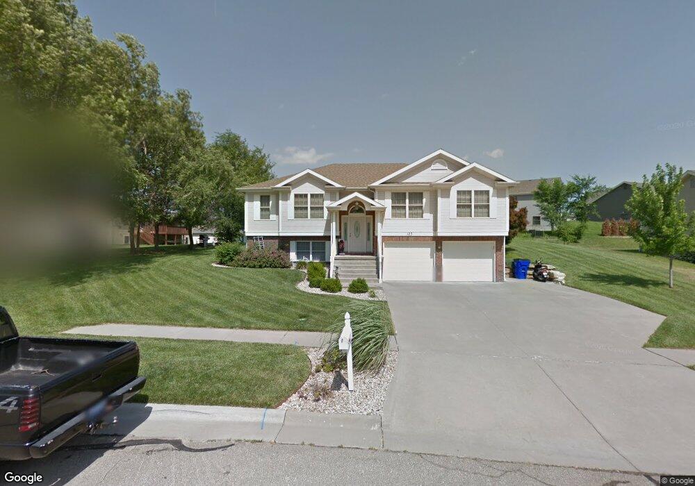
123 Navajo Rd Junction City, KS 66441
Estimated Value: $287,000 - $313,000
4
Beds
3
Baths
1,602
Sq Ft
$187/Sq Ft
Est. Value
About This Home
This home is located at 123 Navajo Rd, Junction City, KS 66441 and is currently estimated at $299,590, approximately $187 per square foot. 123 Navajo Rd is a home located in Geary County with nearby schools including Spring Valley Elementary School, Junction City Middle School, and Junction City Senior High School.
Ownership History
Date
Name
Owned For
Owner Type
Purchase Details
Closed on
Apr 27, 2023
Sold by
Burrafato Matthew J and Burrafato Dawn C
Bought by
Too Wesley and Too Millicent
Current Estimated Value
Home Financials for this Owner
Home Financials are based on the most recent Mortgage that was taken out on this home.
Original Mortgage
$257,000
Outstanding Balance
$249,709
Interest Rate
6.28%
Mortgage Type
VA
Estimated Equity
$49,881
Purchase Details
Closed on
Feb 3, 2017
Sold by
Buckley Fred A and Buckley Katherine J
Bought by
Burrafato Matthew J and Burrafato Dawn C
Home Financials for this Owner
Home Financials are based on the most recent Mortgage that was taken out on this home.
Original Mortgage
$193,000
Interest Rate
4.32%
Create a Home Valuation Report for This Property
The Home Valuation Report is an in-depth analysis detailing your home's value as well as a comparison with similar homes in the area
Home Values in the Area
Average Home Value in this Area
Purchase History
| Date | Buyer | Sale Price | Title Company |
|---|---|---|---|
| Too Wesley | -- | Junction City Abstract Title | |
| Burrafato Matthew J | -- | Heartland Title Services Inc |
Source: Public Records
Mortgage History
| Date | Status | Borrower | Loan Amount |
|---|---|---|---|
| Open | Too Wesley | $257,000 | |
| Previous Owner | Burrafato Matthew J | $193,000 |
Source: Public Records
Tax History Compared to Growth
Tax History
| Year | Tax Paid | Tax Assessment Tax Assessment Total Assessment is a certain percentage of the fair market value that is determined by local assessors to be the total taxable value of land and additions on the property. | Land | Improvement |
|---|---|---|---|---|
| 2025 | $4,531 | $32,983 | $2,965 | $30,018 |
| 2024 | $4,297 | $30,826 | $2,792 | $28,034 |
| 2023 | $4,242 | $28,694 | $2,738 | $25,956 |
| 2022 | $0 | $26,782 | $2,619 | $24,163 |
| 2021 | $0 | $24,127 | $2,456 | $21,671 |
| 2020 | $4,530 | $22,848 | $2,402 | $20,446 |
| 2019 | $4,510 | $22,697 | $2,267 | $20,430 |
| 2018 | $4,411 | $22,195 | $2,261 | $19,934 |
| 2017 | $4,503 | $22,551 | $2,510 | $20,041 |
| 2016 | $4,793 | $24,070 | $1,293 | $22,777 |
| 2015 | $4,532 | $23,419 | $1,566 | $21,853 |
| 2014 | $4,379 | $23,447 | $1,454 | $21,993 |
Source: Public Records
Map
Nearby Homes
- 1912 Winona Cir
- 2204 Elk Ct
- 316 Michaels Way
- 716 Tall Grass Dr
- 1708 Limestone Ln
- 313 Caroline Ct
- 0000 Stoneridge Dr
- 2401 Sawmill Rd
- 2523 Sawmill Rd
- 2533 Sawmill Rd
- 2529 Sawmill Rd
- 2519 Sawmill Rd
- 1041 Sandusky Dr
- 2718 Blaine Ct
- 1308 Sandusky Dr
- 1117 Coyote Dr
- 2448 Fox Sparrow Ct
- 905 Dagen Ln
- 516 Tamerisk Dr
- 2720 Sage Ct