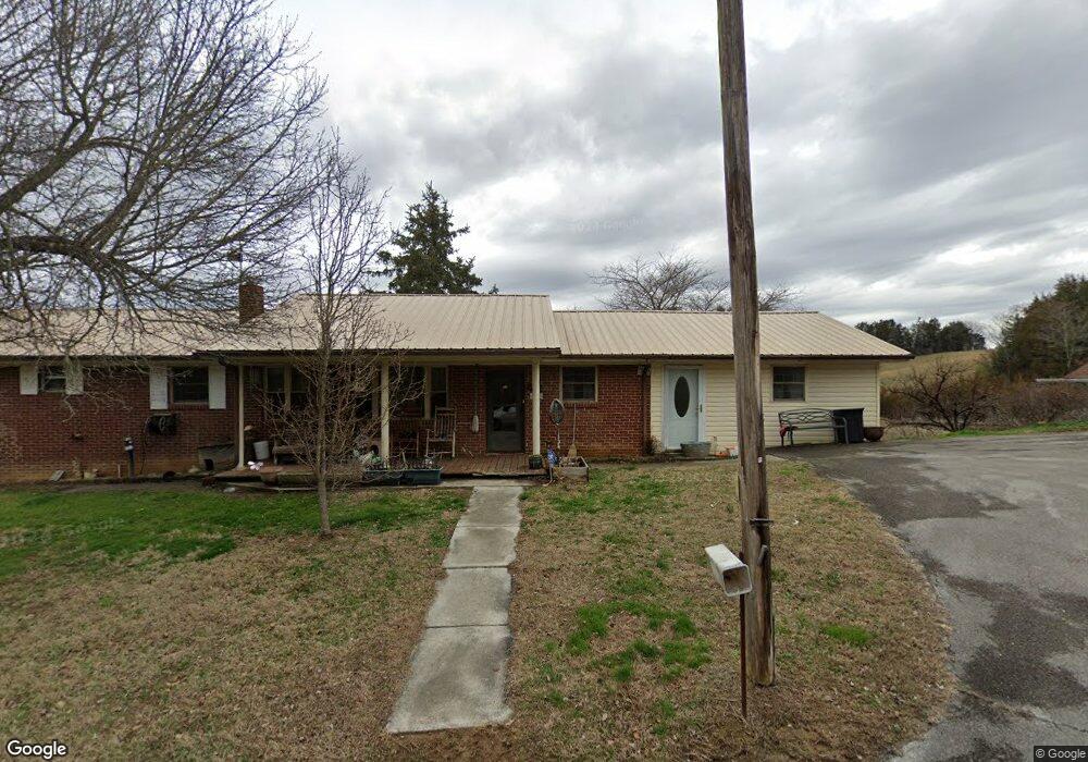
123 Newt Long Rd Bulls Gap, TN 37711
Estimated Value: $179,485 - $296,000
--
Bed
1
Bath
1,606
Sq Ft
$153/Sq Ft
Est. Value
About This Home
This home is located at 123 Newt Long Rd, Bulls Gap, TN 37711 and is currently estimated at $246,495, approximately $153 per square foot. 123 Newt Long Rd is a home located in Hawkins County with nearby schools including Bulls Gap School and Cherokee High School.
Ownership History
Date
Name
Owned For
Owner Type
Purchase Details
Closed on
Jan 2, 2009
Bought by
Parker Sam and Parker Carolyn
Current Estimated Value
Purchase Details
Closed on
Jan 1, 2009
Sold by
Goan Hugh Charles
Bought by
Goan James Robert
Purchase Details
Closed on
Aug 15, 2008
Purchase Details
Closed on
Feb 23, 2008
Sold by
Heirs Goan Louise
Bought by
Sam Parker
Purchase Details
Closed on
Dec 27, 1971
Bought by
Goan Hugh C and Goan Louise
Purchase Details
Closed on
Jun 19, 1969
Create a Home Valuation Report for This Property
The Home Valuation Report is an in-depth analysis detailing your home's value as well as a comparison with similar homes in the area
Home Values in the Area
Average Home Value in this Area
Purchase History
| Date | Buyer | Sale Price | Title Company |
|---|---|---|---|
| Parker Sam | $50,900 | -- | |
| Goan James Robert | $500 | -- | |
| -- | $45,000 | -- | |
| Sam Parker | $23,000 | -- | |
| Goan Hugh C | -- | -- | |
| -- | -- | -- |
Source: Public Records
Tax History Compared to Growth
Tax History
| Year | Tax Paid | Tax Assessment Tax Assessment Total Assessment is a certain percentage of the fair market value that is determined by local assessors to be the total taxable value of land and additions on the property. | Land | Improvement |
|---|---|---|---|---|
| 2024 | $656 | $25,675 | $5,000 | $20,675 |
| 2023 | $597 | $25,675 | $0 | $0 |
| 2022 | $595 | $25,675 | $5,000 | $20,675 |
| 2021 | $557 | $25,675 | $5,000 | $20,675 |
| 2020 | $524 | $25,675 | $5,000 | $20,675 |
| 2019 | $524 | $20,700 | $4,975 | $15,725 |
| 2018 | $524 | $20,700 | $4,975 | $15,725 |
| 2017 | $524 | $20,700 | $4,975 | $15,725 |
| 2016 | $512 | $20,700 | $4,975 | $15,725 |
| 2015 | $499 | $20,225 | $4,975 | $15,250 |
| 2014 | $569 | $23,100 | $5,200 | $17,900 |
Source: Public Records
Map
Nearby Homes
- TBD Gap Creek Rd
- 113 Old Highway Rd
- 231 Guthries Gap Rd
- 0 Guthries Gap Rd Unit 611585
- 000 Simpson Rd
- 251 Speedwell Ln
- 0 Walkers Church
- 204 Meadowview Rd
- 945 N Main St
- 0 Seay Hollow Rd
- Tbd Seay Hollow Rd
- 240 Guthries Greene Rd
- 365 Guthrie Greene Rd
- 438 N Vfw Rd
- 0 Whitehorn Rd Unit 1314385
- 185 Green Rd
- 202 S Shepherd Dr
- 334 S Fork Branch Rd
- 711 N Main St
- 168 Buzzard Roost Rd
- 106 Newt Long Rd
- 225 Lawson Rd
- 206 Beech Grove Rd
- 180 Beech Grove Rd
- 180 Beech Grove Rd Unit 1
- 248 Beech Grove Rd
- 263 Lawson Rd
- 346 Beech Grove Rd
- 347 Beech Grove Rd
- 269 Beech Grove Rd
- 275 Lawson Rd
- 299 Lawson Rd
- 297 Lawson Rd
- 7145 Pilot Mountain Rd
- 106 Cheyanne Ct
- 303 Lawson Rd
- 1401 Highway 66
- Tracts 10- Summit Hill Rd
- 37 Acres Brandon Hollow Ln
- Parcel 14 Speedwell Ln