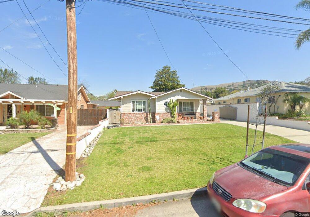
12313 Howard St Whittier, CA 90601
West Whittier NeighborhoodEstimated Value: $763,673 - $921,000
3
Beds
2
Baths
1,314
Sq Ft
$643/Sq Ft
Est. Value
About This Home
This home is located at 12313 Howard St, Whittier, CA 90601 and is currently estimated at $844,418, approximately $642 per square foot. 12313 Howard St is a home located in Los Angeles County with nearby schools including Longfellow Elementary School, Walter F. Dexter Middle School, and Whittier High School.
Ownership History
Date
Name
Owned For
Owner Type
Purchase Details
Closed on
Aug 18, 2020
Sold by
Perez Catherine T
Bought by
Perez Catherine T and Catherine Perez Living Trust
Current Estimated Value
Home Financials for this Owner
Home Financials are based on the most recent Mortgage that was taken out on this home.
Original Mortgage
$264,000
Interest Rate
2.9%
Mortgage Type
New Conventional
Purchase Details
Closed on
Jun 16, 2011
Sold by
Perez Catherine T
Bought by
Perez Catherine T and Catherine Perez Living Trust 2011
Create a Home Valuation Report for This Property
The Home Valuation Report is an in-depth analysis detailing your home's value as well as a comparison with similar homes in the area
Home Values in the Area
Average Home Value in this Area
Purchase History
| Date | Buyer | Sale Price | Title Company |
|---|---|---|---|
| Perez Catherine T | -- | Accommodation | |
| Perez Catherine T | -- | Wfg National Title Co Of Ca | |
| Perez Catherine T | -- | None Available |
Source: Public Records
Mortgage History
| Date | Status | Borrower | Loan Amount |
|---|---|---|---|
| Closed | Perez Catherine T | $264,000 |
Source: Public Records
Tax History Compared to Growth
Tax History
| Year | Tax Paid | Tax Assessment Tax Assessment Total Assessment is a certain percentage of the fair market value that is determined by local assessors to be the total taxable value of land and additions on the property. | Land | Improvement |
|---|---|---|---|---|
| 2025 | $3,680 | $271,756 | $186,603 | $85,153 |
| 2024 | $3,680 | $266,429 | $182,945 | $83,484 |
| 2023 | $3,646 | $261,206 | $179,358 | $81,848 |
| 2022 | $3,530 | $256,086 | $175,842 | $80,244 |
| 2021 | $3,416 | $251,066 | $172,395 | $78,671 |
| 2019 | $3,358 | $243,622 | $167,283 | $76,339 |
| 2018 | $3,154 | $238,846 | $164,003 | $74,843 |
| 2016 | $3,054 | $229,574 | $157,636 | $71,938 |
| 2015 | $2,966 | $226,127 | $155,269 | $70,858 |
| 2014 | $2,943 | $221,698 | $152,228 | $69,470 |
Source: Public Records
Map
Nearby Homes
- 5840 Citrus Ave
- 12417 Rose Dr
- 11840 Nixon Ln
- 12031 Beverly Blvd Unit 1D
- 12429 Floral Dr
- 11905 Mendenhall Ln
- 5655 Pickering Ave
- 12512 Broadway
- 6222 Magnolia Ave
- 12831 Stardell St
- 6251 Milton Ave
- 6217 Greenleaf Ave
- 6333 Milton Ave
- 6242 Comstock Ave
- 6340 Newlin Ave
- 12711 Hadley St Unit 14
- 12708 Hadley St
- 5522 Greenleaf Ave
- 6225 Gretna Ave
- 5827 Washington Ave
- 12307 Howard St
- 12319 Howard St
- 12323 Howard St
- 5822 Citrus Ave
- 12325 Howard St
- 5816 Citrus Ave
- 12312 Orange Dr
- 12318 Orange Dr
- 12327 Howard St
- 5808 Citrus Ave
- 5836 Citrus Ave
- 12322 Orange Dr
- 12314 Howard St
- 12333 Howard St
- 12225 Howard St Unit 2
- 12225 Howard St
- 12328 Orange Dr
- 12322 Howard St
- 12328 Howard St