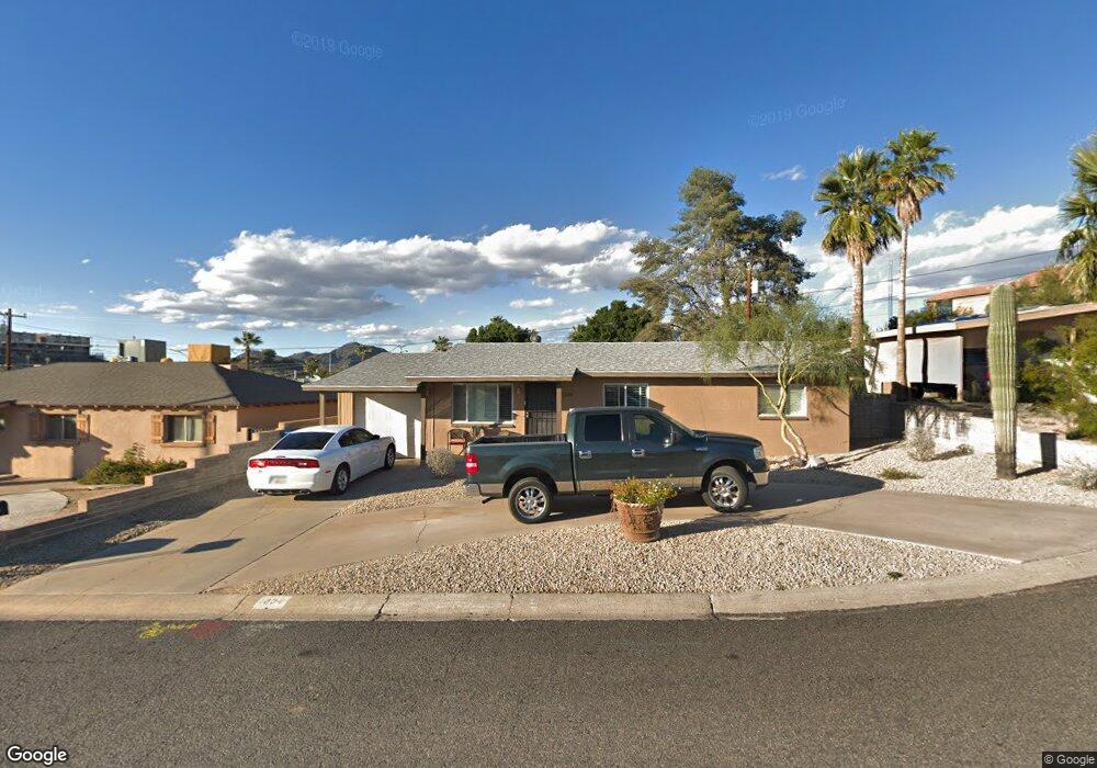
1234 E Griswold Rd Phoenix, AZ 85020
North Central NeighborhoodEstimated Value: $396,069 - $484,000
3
Beds
2
Baths
1,218
Sq Ft
$364/Sq Ft
Est. Value
About This Home
This home is located at 1234 E Griswold Rd, Phoenix, AZ 85020 and is currently estimated at $443,767, approximately $364 per square foot. 1234 E Griswold Rd is a home located in Maricopa County with nearby schools including Desert View Elementary School, Royal Palm Middle School, and Sunnyslope High School.
Ownership History
Date
Name
Owned For
Owner Type
Purchase Details
Closed on
Sep 28, 2011
Sold by
Emerlad City Holdings Llc
Bought by
Boggiano Robert C and Boggiano Michelle Heying
Current Estimated Value
Purchase Details
Closed on
Sep 12, 2011
Sold by
Bakerson Llc
Bought by
Emerald City Holdings Llc
Purchase Details
Closed on
Jul 19, 2011
Sold by
Tavcar Marge
Bought by
Bakerson Llc
Purchase Details
Closed on
Aug 28, 2000
Sold by
Clark Kelly D
Bought by
Tavcar Marge and Tavcar Margaret M
Home Financials for this Owner
Home Financials are based on the most recent Mortgage that was taken out on this home.
Original Mortgage
$86,866
Interest Rate
8.07%
Mortgage Type
FHA
Create a Home Valuation Report for This Property
The Home Valuation Report is an in-depth analysis detailing your home's value as well as a comparison with similar homes in the area
Home Values in the Area
Average Home Value in this Area
Purchase History
| Date | Buyer | Sale Price | Title Company |
|---|---|---|---|
| Boggiano Robert C | $76,700 | Equity Title Agency Inc | |
| Emerald City Holdings Llc | -- | None Available | |
| Bakerson Llc | $54,201 | None Available | |
| Tavcar Marge | $87,000 | Security Title Agency |
Source: Public Records
Mortgage History
| Date | Status | Borrower | Loan Amount |
|---|---|---|---|
| Previous Owner | Tavcar Marge | $86,866 |
Source: Public Records
Tax History
| Year | Tax Paid | Tax Assessment Tax Assessment Total Assessment is a certain percentage of the fair market value that is determined by local assessors to be the total taxable value of land and additions on the property. | Land | Improvement |
|---|---|---|---|---|
| 2025 | $1,535 | $12,079 | -- | -- |
| 2024 | $1,450 | $11,503 | -- | -- |
| 2023 | $1,450 | $31,130 | $6,220 | $24,910 |
| 2022 | $1,403 | $22,960 | $4,590 | $18,370 |
| 2021 | $1,421 | $21,850 | $4,370 | $17,480 |
| 2020 | $1,386 | $19,720 | $3,940 | $15,780 |
| 2019 | $1,360 | $16,730 | $3,340 | $13,390 |
| 2018 | $1,325 | $15,660 | $3,130 | $12,530 |
| 2017 | $1,318 | $14,160 | $2,830 | $11,330 |
| 2016 | $1,294 | $14,070 | $2,810 | $11,260 |
| 2015 | $1,198 | $14,810 | $2,960 | $11,850 |
Source: Public Records
Map
Nearby Homes
- 8149 N 13th Place
- 1214 E Las Palmaritas Dr
- 8220 N 14th St Unit 1
- 1402 E Las Palmaritas Dr
- 1214 E Butler Dr
- 8050 N 11th Place
- 1448 E Royal Palm Rd
- 1450 E Royal Palm Rd
- 1130 E Butler Dr Unit A1
- 1001 E Griswold Rd Unit 34
- 8120 N 10th Place
- 8112 N 10th Place
- 8049 N 10th St
- 8603 N 14th St
- 1114 E Orchid Ln
- 8607 N 14th St Unit 229
- 1237 E Ruth Ave
- 8216 N 9th St
- 1207 E Alice Ave
- 1201 E Desert Park Ln
- 1228 E Griswold Rd
- 1240 E Griswold Rd
- 1239 E El Camino Dr
- 1222 E Griswold Rd
- 1227 E El Camino Dr
- 1233 E Griswold Rd
- 1227 E Griswold Rd
- 1248 E Griswold Rd Unit 9
- 1221 E El Camino Dr
- 1239 E Griswold Rd
- 1214 E Griswold Rd
- 1221 E Griswold Rd
- 1247 E El Camino Dr
- 1247 E Griswold Rd Unit 12
- 1213 E El Camino Dr
- 1213 E Griswold Rd
- 1232 E Royal Palm Cir
- 1208 E Griswold Rd
- 1234 E El Camino Dr
- 1238 E Royal Palm Cir
Your Personal Tour Guide
Ask me questions while you tour the home.