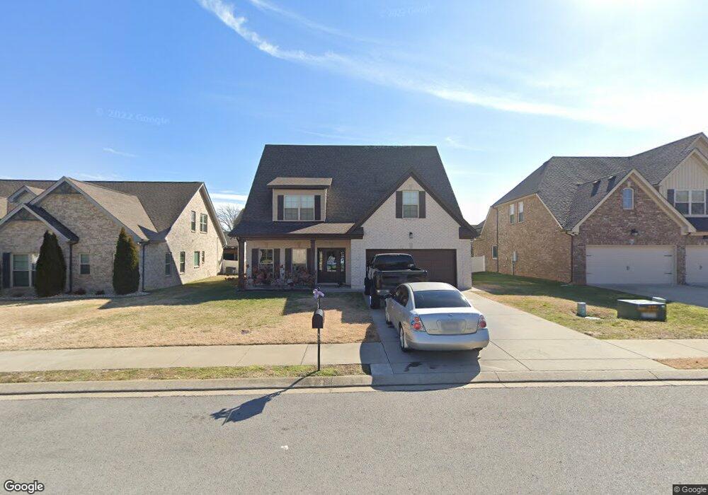
1236 Hensfield Dr Murfreesboro, TN 37128
Estimated Value: $544,216 - $599,000
--
Bed
--
Bath
2,678
Sq Ft
$216/Sq Ft
Est. Value
About This Home
This home is located at 1236 Hensfield Dr, Murfreesboro, TN 37128 and is currently estimated at $578,304, approximately $215 per square foot. 1236 Hensfield Dr is a home with nearby schools including Blackman Elementary School, Overall Creek Elementary School, and Blackman Middle School.
Ownership History
Date
Name
Owned For
Owner Type
Purchase Details
Closed on
Dec 7, 2016
Sold by
Harney Homes Llc
Bought by
Mcree Anna Margaretta and Mcree Kenneth Taylor
Current Estimated Value
Home Financials for this Owner
Home Financials are based on the most recent Mortgage that was taken out on this home.
Original Mortgage
$230,400
Outstanding Balance
$185,756
Interest Rate
3.47%
Mortgage Type
New Conventional
Estimated Equity
$392,548
Purchase Details
Closed on
Mar 11, 2016
Sold by
Holmes By Design Llc
Bought by
Harney Homes Llc
Create a Home Valuation Report for This Property
The Home Valuation Report is an in-depth analysis detailing your home's value as well as a comparison with similar homes in the area
Home Values in the Area
Average Home Value in this Area
Purchase History
| Date | Buyer | Sale Price | Title Company |
|---|---|---|---|
| Mcree Anna Margaretta | $293,000 | Lawyers Land & Title Svcs L | |
| Harney Homes Llc | $160,000 | -- |
Source: Public Records
Mortgage History
| Date | Status | Borrower | Loan Amount |
|---|---|---|---|
| Open | Mcree Anna Margaretta | $230,400 |
Source: Public Records
Tax History Compared to Growth
Tax History
| Year | Tax Paid | Tax Assessment Tax Assessment Total Assessment is a certain percentage of the fair market value that is determined by local assessors to be the total taxable value of land and additions on the property. | Land | Improvement |
|---|---|---|---|---|
| 2025 | $3,133 | $110,750 | $13,750 | $97,000 |
| 2024 | $3,133 | $110,750 | $13,750 | $97,000 |
| 2023 | $2,078 | $110,750 | $13,750 | $97,000 |
| 2022 | $1,790 | $110,750 | $13,750 | $97,000 |
| 2021 | $1,815 | $81,800 | $13,750 | $68,050 |
| 2020 | $1,815 | $81,800 | $13,750 | $68,050 |
| 2019 | $1,815 | $81,800 | $13,750 | $68,050 |
Source: Public Records
Map
Nearby Homes
- 5227 Starnes Dr
- 1232 Stockwell Dr
- 1235 Timber Creek Dr
- 4814 Saint Ives Dr
- 2108 Olmstead Ct
- 5108 Saint Ives Dr
- 1343 Dunraven Dr
- 629 Brinkley Rd
- 4826 Trevino Ct
- 5350 Tony Lama Ln
- 5309 Perlou Ln
- 827 Stovers Glen Dr
- 548 Brinkley Rd
- 5408 Middlebury Dr
- 814 Stovers Glen
- 802 Licinius Ln
- 826 Licinius Ln
- 628 Evergreen Dr
- 4670 Forsman Ct
- 5313 Eiffel Ct
- 1240 Hensfield
- 1137 Stockwell Dr
- 1244 Hensfield Dr
- 1228 Hensfield Dr Unit 231
- 1228 Hensfield Dr - Lot 231
- 1228 Hensfield Dr
- 1133 Stockwell Dr
- 1145 Stockwell Dr
- 1133 Stockwell Dr
- 1237 Hensfield
- 1233 Hensfield Dr
- 203 Stockwell Drive #203
- 1129 Stockwell Dr
- 1248 Hensfield Dr Unit 236
- 1248 Hensfield Dr
- 1248 Hensfield Dr (Lot 236)
- 1224 Hensfield
- 1149 Stockwell Dr
- 1129 Stockwell Drive - Lot 192