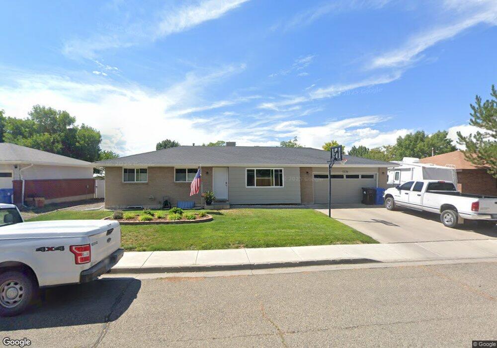
1236 Leeds Ave Montrose, CO 81401
Estimated Value: $409,542 - $438,000
4
Beds
2
Baths
2,126
Sq Ft
$201/Sq Ft
Est. Value
About This Home
This home is located at 1236 Leeds Ave, Montrose, CO 81401 and is currently estimated at $427,136, approximately $200 per square foot. 1236 Leeds Ave is a home located in Montrose County with nearby schools including Pomona Elementary School, Columbine Middle School, and Montrose High School.
Ownership History
Date
Name
Owned For
Owner Type
Purchase Details
Closed on
Oct 19, 2022
Sold by
Hebbel David H and Hebbel Robin R
Bought by
Hebbel David H and Hebbel Robin R
Current Estimated Value
Purchase Details
Closed on
Mar 3, 1999
Sold by
Landen Steven Todd and Landen Rebecca L
Bought by
Hebbel David H and Hebbel Robin R
Purchase Details
Closed on
Jan 28, 1994
Sold by
H & P Construction Co Inc
Bought by
Landen Steven Todd and Landen Rebecca L
Purchase Details
Closed on
Sep 15, 1993
Sold by
Phillips Construction Co Inc
Bought by
H & P Construction Co Inc
Create a Home Valuation Report for This Property
The Home Valuation Report is an in-depth analysis detailing your home's value as well as a comparison with similar homes in the area
Home Values in the Area
Average Home Value in this Area
Purchase History
| Date | Buyer | Sale Price | Title Company |
|---|---|---|---|
| Hebbel David H | -- | None Listed On Document | |
| Hebbel David H | $123,500 | -- | |
| Landen Steven Todd | $79,800 | -- | |
| H & P Construction Co Inc | $13,600 | -- |
Source: Public Records
Tax History Compared to Growth
Tax History
| Year | Tax Paid | Tax Assessment Tax Assessment Total Assessment is a certain percentage of the fair market value that is determined by local assessors to be the total taxable value of land and additions on the property. | Land | Improvement |
|---|---|---|---|---|
| 2024 | $1,570 | $21,780 | $3,150 | $18,630 |
| 2023 | $1,570 | $26,410 | $3,820 | $22,590 |
| 2022 | $1,231 | $17,640 | $2,780 | $14,860 |
| 2021 | $1,268 | $18,150 | $2,860 | $15,290 |
| 2020 | $1,091 | $16,050 | $2,470 | $13,580 |
| 2019 | $1,098 | $16,050 | $2,470 | $13,580 |
| 2018 | $913 | $13,010 | $1,990 | $11,020 |
| 2017 | $906 | $13,010 | $1,990 | $11,020 |
| 2016 | $841 | $12,280 | $2,010 | $10,270 |
| 2015 | $827 | $12,280 | $2,010 | $10,270 |
| 2014 | $774 | $12,290 | $2,010 | $10,280 |
Source: Public Records
Map
Nearby Homes
- 1239 Leeds Ave
- 1323 Manchester Dr
- 1219 Peppertree Dr
- 2555 Iris Ct
- 1119 Phillips Ct
- 1119 Phillips Ct Unit G
- 1119 Phillips Ct Unit A
- 2409 Pecan St
- 2210 Devon St
- 1510 Kent Ave Unit A
- 1510 Kent Ave
- 2130 Devon St
- 2136 Stratford Dr Unit A
- 2135 Winston Way Unit B
- 2250 Phillips Cir
- 2125 Hartford Way Unit A
- 2345 Phillips Cir Unit D
- 2055 Princeton Way Unit A
- 2799 Stoney Creek Ln
- 2036 Scarborough Way Unit J
- 1242 Leeds Ave
- 1241 Manchester Dr
- 1235 Manchester Dr
- 1245 Manchester Dr
- 1248 Leeds Ave
- 1226 Leeds Ave
- 1229 Manchester Dr
- 1251 Manchester Dr
- 1300 Leeds Ave
- 1224 Leeds Ave
- 1240 Manchester Dr
- 1234 Manchester Dr
- 1223 Manchester Dr
- 1246 Manchester Dr
- 1227 Leeds Ave
- 1305 Manchester Dr
- 1306 Leeds Ave
- 1228 Manchester Dr
- 1302 Manchester Dr
- 1222 Manchester Dr