Estimated Value: $569,528 - $665,000
3
Beds
2
Baths
1,624
Sq Ft
$371/Sq Ft
Est. Value
About This Home
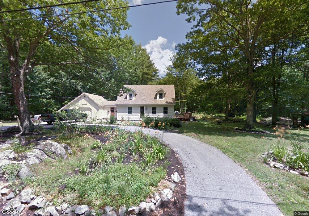
This home is located at 1237 Coles Hill Rd, Wells, ME 04090 and is currently estimated at $603,132, approximately $371 per square foot. 1237 Coles Hill Rd is a home located in York County with nearby schools including Wells Junior High School, Wells Elementary School, and Wells High School.
Ownership History
Date
Name
Owned For
Owner Type
Purchase Details
Closed on
Jan 27, 2005
Sold by
Milinski Michael
Bought by
Stevens Taunya M and Stevens Robert B
Current Estimated Value
Home Financials for this Owner
Home Financials are based on the most recent Mortgage that was taken out on this home.
Original Mortgage
$212,000
Outstanding Balance
$103,555
Interest Rate
5.67%
Mortgage Type
Purchase Money Mortgage
Estimated Equity
$499,577
Create a Home Valuation Report for This Property
The Home Valuation Report is an in-depth analysis detailing your home's value as well as a comparison with similar homes in the area
Home Values in the Area
Average Home Value in this Area
Purchase History
| Date | Buyer | Sale Price | Title Company |
|---|---|---|---|
| Stevens Taunya M | -- | -- |
Source: Public Records
Mortgage History
| Date | Status | Borrower | Loan Amount |
|---|---|---|---|
| Open | Stevens Taunya M | $212,000 | |
| Closed | Stevens Taunya M | $53,000 |
Source: Public Records
Tax History
| Year | Tax Paid | Tax Assessment Tax Assessment Total Assessment is a certain percentage of the fair market value that is determined by local assessors to be the total taxable value of land and additions on the property. | Land | Improvement |
|---|---|---|---|---|
| 2025 | $2,975 | $460,520 | $183,520 | $277,000 |
| 2024 | $2,800 | $460,520 | $183,520 | $277,000 |
| 2023 | $2,745 | $460,520 | $183,520 | $277,000 |
| 2022 | $2,385 | $228,040 | $83,260 | $144,780 |
| 2021 | $2,399 | $228,040 | $70,130 | $157,910 |
| 2020 | $2,383 | $227,370 | $83,260 | $144,110 |
| 2019 | $2,342 | $224,740 | $83,260 | $141,480 |
| 2018 | $2,319 | $224,740 | $83,260 | $141,480 |
| 2017 | $2,283 | $224,740 | $83,260 | $141,480 |
| 2016 | $2,261 | $224,740 | $83,260 | $141,480 |
| 2015 | $2,236 | $224,740 | $83,260 | $141,480 |
| 2013 | $2,050 | $224,740 | $83,260 | $141,480 |
Source: Public Records
Map
Nearby Homes
- 77 Clark Rd
- lot 3 Lydias Cir
- lot 20 Lydias Cir
- lot 12 Lydia's Cir
- 1007 Branch Rd
- 00 Farm View Ln
- 557 Coles Hill Rd
- 162 Millbrooke Farm Dr Unit 162
- 160 Millbrooke Farm Dr Unit 160
- Lot 4 Cider Press Ln
- 59 Webber Hill Rd
- 9 Hammond Rd
- 222 Hobbs Farm Rd Unit Lot 9
- 222 Hobbs Farm Rd Unit Lot 6
- 222 Hobbs Farm Rd Unit Lot 10
- 222 Hobbs Farm Rd Unit Lot 7
- 222 Hobbs Farm Rd Unit Lot 8
- 15 Heritage Dr Unit 15
- 17 Hampton Glen Dr Unit 5
- 9 Hampton Glen Dr Unit 3
- 1234 Coles Hill Rd
- 1211 Coles Hill Rd
- 1397 Branch Rd
- 1361 Branch Rd
- 1189 Coles Hill Rd
- 1384 Branch Rd
- 1421 Branch Rd
- Lot 19 Clark Rd
- Lot 19 A Clark Rd
- LOT 19B Clark Rd
- LOT 19A Clark Rd
- LOT 19A (Tbb) Clark Rd
- 1431 Branch Rd
- 1325 Branch Rd
- 1428 Branch Rd
- Lot 26B Clark Rd
- MAP 83 Lot 32 Clark Rd
- LOT 32C Clark Rd
- LOT 32B Clark Rd
- LOT 32A Clark Rd
Your Personal Tour Guide
Ask me questions while you tour the home.