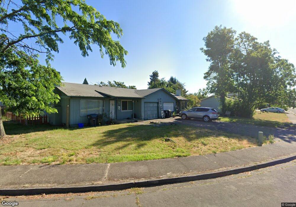
1238 Kenray Loop Springfield, OR 97477
Gateway NeighborhoodEstimated Value: $387,237 - $434,000
4
Beds
2
Baths
1,745
Sq Ft
$239/Sq Ft
Est. Value
About This Home
This home is located at 1238 Kenray Loop, Springfield, OR 97477 and is currently estimated at $417,059, approximately $239 per square foot. 1238 Kenray Loop is a home located in Lane County with nearby schools including Guy Lee Elementary School, Hamlin Middle School, and Springfield High School.
Ownership History
Date
Name
Owned For
Owner Type
Purchase Details
Closed on
Jun 28, 2004
Sold by
Morris Geroge L and Morris Connie M
Bought by
Miller Michael P
Current Estimated Value
Home Financials for this Owner
Home Financials are based on the most recent Mortgage that was taken out on this home.
Original Mortgage
$200,000
Interest Rate
6.31%
Mortgage Type
Purchase Money Mortgage
Create a Home Valuation Report for This Property
The Home Valuation Report is an in-depth analysis detailing your home's value as well as a comparison with similar homes in the area
Home Values in the Area
Average Home Value in this Area
Purchase History
| Date | Buyer | Sale Price | Title Company |
|---|---|---|---|
| Miller Michael P | $586,000 | Western Pioneer Title Co |
Source: Public Records
Mortgage History
| Date | Status | Borrower | Loan Amount |
|---|---|---|---|
| Closed | Miller Michael P | $200,000 |
Source: Public Records
Tax History
| Year | Tax Paid | Tax Assessment Tax Assessment Total Assessment is a certain percentage of the fair market value that is determined by local assessors to be the total taxable value of land and additions on the property. | Land | Improvement |
|---|---|---|---|---|
| 2025 | $3,853 | $210,112 | -- | -- |
| 2024 | $3,791 | $203,993 | -- | -- |
| 2023 | $3,791 | $198,052 | $0 | $0 |
| 2022 | $3,511 | $192,284 | $0 | $0 |
| 2021 | $3,448 | $186,684 | $0 | $0 |
| 2020 | $3,347 | $181,247 | $0 | $0 |
| 2019 | $3,246 | $175,968 | $0 | $0 |
| 2018 | $3,060 | $165,867 | $0 | $0 |
| 2017 | $2,943 | $165,867 | $0 | $0 |
| 2016 | $2,881 | $161,036 | $0 | $0 |
| 2015 | $2,799 | $156,346 | $0 | $0 |
| 2014 | $2,756 | $151,792 | $0 | $0 |
Source: Public Records
Map
Nearby Homes
- 446 Kodiak St
- 898 Lochaven Ave
- 2727 Gateway St Unit 27
- 3579 Oxbow Way
- 3700 Babcock Ln Unit 119
- 3700 Babcock Ln Unit 106
- 825 Waverly St
- 2846 El Toro Ct
- 3460 Oxbow Way
- 1038 President St
- 484 Scotts Glen Dr
- 485 Scotts Glen Dr
- 451 Lochaven Ave
- 1271 Arcadia Dr
- 1270 Calvin St
- 804 W N St
- 2150 Laura (#57) St Unit 57
- 2150 Laura St Unit 119
- 2150 Laura St Unit 111
- 2150 Laura St Unit 39
- 1260 Kenray Loop
- 1220 Kenray Loop
- 1264 Kenray Loop
- 1233 Kenray Loop
- 1257 Kenray Loop
- 1261 Kenray Loop
- 1245 Kenray Loop
- 0 Kenray Loop
- 1273 Kenray Loop
- 1271 Kenray Loop
- 1211 Kenray Loop
- 1269 Kenray Loop
- 2324 Dornoch St
- 1278 Kenray Loop
- 2340 Dornoch St
- 1264 Lorne Loop
- 1268 Lorne Loop
- 2356 Dornoch St
- 1201 Kenray Loop
- 1280 Kenray Loop
Your Personal Tour Guide
Ask me questions while you tour the home.